


For 7000 ft. to 8000 ft.
| Wednesday | Wednesday Night | Thursday | |
|---|---|---|---|
| Weather: | Cloudy skies, becoming partly cloudy. Snow in the morning. Isolated snow showers in the afternoon. | Clear skies. | Sunny skies. |
| Temperatures: | 28 to 33 deg. F. | 20 to 26 deg. F. | 39 to 44 deg. F. |
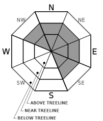
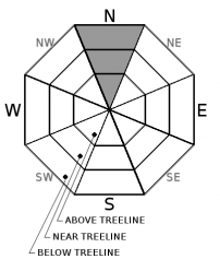
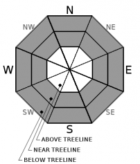
| Mid Slope Winds: | SW | SW | S |
| Wind Speed: | 20 to 30 mph. Gusts to 60 mph, decreasing to 45 mph in the afternoon. | Light winds with gusts to 30 mph in the evening. | Light winds becoming 10 to 15 mph in the afternoon. Gusts to 30 mph. |
| Expected snowfall: | Up to 2 | 0 | 0 |
For 8000 ft. to 9000 ft.
| Wednesday | Wednesday Night | Thursday | |
|---|---|---|---|
| Weather: | Cloudy skies, becoming partly cloudy. Snow in the morning. Isolated snow showers in the afternoon. | Clear skies. | Sunny skies. |
| Temperatures: | 24 to 30 deg. F. | 20 to 25 deg. F. | 34 to 40 deg. F. |
| Ridge Top Winds: | SW to W | SW | SW |
| Wind Speed: | 25 to 40 mph with gusts to 80 mph, decreasing to 20 to 30 mph with gusts to 65 mph in the afternoon. | 15 to 20 mph with gusts to 40 mph. | 15 to 25 mph with gusts to 40 mph. Gusts increasing to 50 mph in the afternoon. |
| Expected snowfall: | Up to 2 | 0 | 0 |


