THIS AVALANCHE FORECAST EXPIRED ON April 11, 2017 @ 6:46 am
Avalanche Forecast published on April 10, 2017 @ 6:46 am
Issued by Brandon Schwartz - Tahoe National Forest

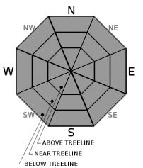
Very early this morning, avalanche danger is LOW for all elevations. From mid morning onwards, areas of MODERATE avalanche danger are expected at all elevations as loose wet avalanche problems develop in response to daytime warming. Instability will become increasingly widespread during the afternoon hours.

2. Moderate

?

Above Treeline
Heightened avalanche conditions on specific terrain features. Evaluate snow and terrain carefully; identify features of concern.

2. Moderate

?

Near Treeline
Heightened avalanche conditions on specific terrain features. Evaluate snow and terrain carefully; identify features of concern.

2. Moderate

?

Below Treeline
Heightened avalanche conditions on specific terrain features. Evaluate snow and terrain carefully; identify features of concern.
    Heightened avalanche conditions on specific terrain features. Evaluate snow and terrain carefully; identify features of concern.
Avalanche Problem 1: Loose Wet
  • Type ?
  • Aspect/Elevation ?
  • Likelihood ?
    Certain
    Very Likely
    Likely
    Possible
    Unlikely
  • Size ?
    Historic
    Very Large
    Large
    Small

Further warming is expected today with the anticipated result of further wetting of recent storm snow. This is expected to spread to any sun exposed areas on all aspects at all elevations. This warming and snow surface wetting will allow for another round of loose wet avalanche activity, mostly human triggered. Isolated natural loose wet avalanches could still occur today, especially if triggered by cornice fall.

Avoid travel on or below slopes steeper than about 35 degrees where natural or human triggered roller balls are occurring. Avoid areas around large cornices, especially if they are dripping melt water. Cornice fall during warming conditions tends to have very low predictability and a high degree of uncertainty.

recent observations

Natural and human triggered loose wet avalanches were noted in numerous locations around the forecast area yesterday on sun exposed slopes. Rapid warming conditions were noted in most areas yesterday. Exceptions existed, mainly on some of the higher elevation and more shaded north aspects where recent storm snow escaped entering into melt phase. Signs of a couple of recent wind slab avalanches most likely from Saturday with crowns to 3+ feet were reported. Little to no signs of ongoing wind slab instability were observed yesterday.


Weather and CURRENT CONDITIONS
weather summary

The warming trend will continue today under partly cloudy skies. Above freezing air temperatures are expected at all elevations. Moderate speed SW winds over the upper elevations are expected today. Winds are forecast to increase to moderate to strong in speed for Tuesday. Increasing cloud cover and chances for very light precipitation return to the region Tuesday. Increasing amounts of precipitation are expected Wednesday and Thursday.

CONDITIONS ALONG THE SIERRA CREST BETWEEN 8200 FT. AND 9200 FT. IN THE LAST 24 HOURS
6am temperature: 15 to 26 deg. F.
Max. temperature: 31 to 41 deg. F.
Average ridgetop wind direction: SW
Average ridgetop wind speed: 31 mph
Maximum ridgetop wind gust: 52 mph
New snowfall: 0 inches
Total snow depth: 130 to 192 inches
Two-Day Mountain Weather Forecast Produced in partnership with the Reno NWS
For 7000 ft. to 8000 ft.
Monday Monday Night Tuesday
Weather: Partly cloudy skies. Partly cloudy skies, becoming mostly cloudy. Mostly cloudy skies, becoming cloudy. Slight chance of snow in the morning. A chance of snow in the afternoon.
Temperatures: 40 to 46 deg. F. 24 to 29 deg. F. 42 to 48 deg. F.
Mid Slope Winds: SW SW SW
Wind Speed: Light winds Light winds 15 to 20 mph. Gusts to 30 mph increasing to 40 mph in the afternoon.
Expected snowfall: 0 0 0 to trace
For 8000 ft. to 9000 ft.
Monday Monday Night Tuesday
Weather: Partly cloudy skies. Partly cloudy skies, becoming mostly cloudy. Mostly cloudy skies, becoming cloudy. Slight chance of snow in the morning. A chance of snow in the afternoon.
Temperatures: 36 to 42 deg. F. 23 to 28 deg. F. 38 to 44 deg. F.
Ridge Top Winds: SW SW SW
Wind Speed: 15 to 25 mph. Gusts up to 50 mph decreasing to 40 mph in the afternoon. 15 to 20 mph with gusts to 40 mph. 20 to 30 mph. Gusts to 60 mph increasing to 70 mph in the afternoon.
Expected snowfall: 0 0 0 to trace
Disclaimer

This avalanche advisory is provided through a partnership between the Tahoe National Forest and the Sierra Avalanche Center. This advisory covers the Central Sierra Nevada Mountains between Yuba Pass on the north and Ebbetts Pass on the south. Click here for a map of the forecast area. This advisory applies only to backcountry areas outside established ski area boundaries. This advisory describes general avalanche conditions and local variations always occur. This advisory expires 24 hours after the posted time unless otherwise noted. The information in this advisory is provided by the USDA Forest Service who is solely responsible for its content.

For a recorded version of the Avalanche Advisory call (530) 587-3558 x258