THIS AVALANCHE FORECAST EXPIRED ON April 18, 2017 @ 6:47 am
Avalanche Forecast published on April 17, 2017 @ 6:47 am
Issued by Brandon Schwartz - Tahoe National Forest

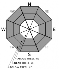
MODERATE avalanche danger exists at all elevations due to a combination of wind slab and loose wet avalanche problems. Human triggered avalanches are possible today. Natural avalanches are unlikely but not impossible in isolated areas. Identify and avoid slopes where wind slab or loose wet avalanche problems may exist.

2. Moderate

?

Above Treeline
Heightened avalanche conditions on specific terrain features. Evaluate snow and terrain carefully; identify features of concern.

2. Moderate

?

Near Treeline
Heightened avalanche conditions on specific terrain features. Evaluate snow and terrain carefully; identify features of concern.

2. Moderate

?

Below Treeline
Heightened avalanche conditions on specific terrain features. Evaluate snow and terrain carefully; identify features of concern.
    Heightened avalanche conditions on specific terrain features. Evaluate snow and terrain carefully; identify features of concern.
Avalanche Problem 1: Wind Slab
  • Type ?
  • Aspect/Elevation ?
  • Likelihood ?
    Certain
    Very Likely
    Likely
    Possible
    Unlikely
  • Size ?
    Historic
    Very Large
    Large
    Small

New wind slabs formed last night and are expected to gain some additional size with snow showers today. Wind slab avalanche problems are expected above 7,500' today in near and above treeline terrain. The vast majority of wind slabs will be found on NW-N-NE-E-SE aspects. Expected size ranges from very small to large enough to bury or injure a person, especially if cliffs or terrain traps are involved.

Identify and avoid areas of recently wind drifted snow, most likely found below or adjacent to cornice features or wind pillows.


Avalanche Problem 2: Loose Wet
  • Type ?
  • Aspect/Elevation ?
  • Likelihood ?
    Certain
    Very Likely
    Likely
    Possible
    Unlikely
  • Size ?
    Historic
    Very Large
    Large
    Small

Widespread areas of surface wet snow will be found on all aspects below 8,000' from start to finish today. This surface wet snow was created by snow surface melt yesterday and rain to 7,500' last night. Rain to 8,000' today will keep surface wet snow ongoing. Loose wet avalanche problems are expected today on all aspects. The vast majority of instability is expected to be found below 8,000', but could exist at higher elevations in isolated areas. Expected size ranges from small to large enough to bury a person.

Avoid travel on or below steep slopes where a few inches or more of surface wet snow exist.

recent observations

Observations made yesterday on Rubicon Peak (West Shore Tahoe area) and on Powderhouse Peak (Luther Pass area) found unstable wet snow. On Rubicon Peak, signs of loose wet avalanche problems had formed on E aspects around 9,000' by late morning. On Powderhouse Peak, signs of loose wet avalanche problems were noted to spread to shaded NE aspects during the early afternoon hours.

Weather and CURRENT CONDITIONS
weather summary

A series of weather systems continue to move through the forecast area. Snow level is expected to rise to 7,500' to 8,000' today. Light rain and snow showers are expected through this evening. The next wave of precipitation is forecast to move through the region early Tuesday morning with snow levels lowering to 6,500' to 7,000'. Ridgetop winds are gale force out of the SW this morning. Strong to gale force winds are forecast to continue through tonight, gradually decreasing in speed tomorrow.

CONDITIONS ALONG THE SIERRA CREST BETWEEN 8200 FT. AND 9200 FT. IN THE LAST 24 HOURS
6am temperature: 33 to 35 deg. F.
Max. temperature: 38 to 46 deg. F.
Average ridgetop wind direction: SW
Average ridgetop wind speed: 55 mph
Maximum ridgetop wind gust: 124 mph
New snowfall: 2 to 5 inches
Total snow depth: 130 to 198 inches
Two-Day Mountain Weather Forecast Produced in partnership with the Reno NWS
For 7000 ft. to 8000 ft.
Monday Monday Night Tuesday
Weather: Cloudy skies with rain and snow showers. Cloudy skies with rain and snow showers. Cloudy skies with rain and snow.
Temperatures: 44 to 52 deg. F. 31 to 36 deg. F. 38 to 44 deg. F.
Mid Slope Winds: SW SW SW
Wind Speed: 15 to 25 mph. Gusts to 60 mph decreasing to 50 mph in the afternoon. 15 to 25 mph with gusts to 50 mph. 15 to 20 mph with gusts to 40 mph.
Expected snowfall: Up to 2 2 to 4 2 to 4
For 8000 ft. to 9000 ft.
Monday Monday Night Tuesday
Weather: Cloudy skies with snow showers in the morning. Rain and snow showers in the afternoon. Cloudy skies with snow showers. Cloudy skies with snow.
Temperatures: 35 to 43 deg. F. 28 to 33 deg. F. 32 to 40 deg. F.
Ridge Top Winds: SW SW SW
Wind Speed: 30 to 45 mph with gusts to 90 mph. 25 to 40 mph with gusts to 75 mph. 20 to 30 mph. Gusts up to 60 mph decreasing to 45 mph in the afternoon.
Expected snowfall: Up to 3 2 to 4 2 to 4
Disclaimer

This avalanche advisory is provided through a partnership between the Tahoe National Forest and the Sierra Avalanche Center. This advisory covers the Central Sierra Nevada Mountains between Yuba Pass on the north and Ebbetts Pass on the south. Click here for a map of the forecast area. This advisory applies only to backcountry areas outside established ski area boundaries. This advisory describes general avalanche conditions and local variations always occur. This advisory expires 24 hours after the posted time unless otherwise noted. The information in this advisory is provided by the USDA Forest Service who is solely responsible for its content.

For a recorded version of the Avalanche Advisory call (530) 587-3558 x258