


For 7000 ft. to 8000 ft.
| Tuesday | Tuesday Night | Wednesday | |
|---|---|---|---|
| Weather: | Cloudy skies with rain and snow in the morning. A chance of rain and snow in the afternoon. | Partly cloudy skies. Isolated rain and snow showers in the evening. | Partly cloudy skies. |
| Temperatures: | 34 to 44 deg. F. | 23 to 29 deg. F. | 44 to 50 deg. F. |
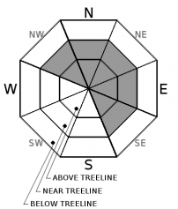
| Mid Slope Winds: | SW | SW | SW |
| Wind Speed: | 15 to 20 mph with gusts to 40 mph. | 10 to 15 mph with gusts to 35 mph in the evening, becoming light. | Light winds becoming 15 to 25 mph with gusts to 45 mph in the afternoon. |
| Expected snowfall: | Up to 2 | 0 to trace | 0 |
For 8000 ft. to 9000 ft.
| Tuesday | Tuesday Night | Wednesday | |
|---|---|---|---|
| Weather: | Cloudy skies with rain and snow in the morning. A chance of rain and snow in the afternoon. | Partly cloudy skies. Isolated snow showers in the evening. | Partly cloudy skies. |
| Temperatures: | 28 to 38 deg. F. | 19 to 24 deg. F. | 35 to 45 deg. F. |
| Ridge Top Winds: | SW | SW | SW |
| Wind Speed: | 20 to 35 mph. Gusts to 75 mph decreasing to 60 mph in the afternoon. | 20 to 30 mph. Gusts to 60 mph decreasing to 50 mph after midnight. | 20 to 30 mph. Gusts to 55 mph increasing to 75 mph in the afternoon. |
| Expected snowfall: | 1 to 2 | 0 to trace | 0 |


