


For 7000 ft. to 8000 ft.
| Sunday | Sunday Night | Monday | |
|---|---|---|---|
| Weather: | Mostly sunny. | Partly cloudy. | Mostly cloudy. Slight chance of snow showers in the morning. |
| Temperatures: | 33 to 38 deg. F. | 21 to 27 deg. F. | 37 to 43 deg. F. |
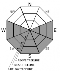
| Mid Slope Winds: | SW | ||
| Wind Speed: | Light winds. | Light winds becoming 10 to 15mph after midnight. Gusts up to 35mph. | Light winds. |
| Expected snowfall: | 0 | 0 | 0 |
For 8000 ft. to 9000 ft.
| Sunday | Sunday Night | Monday | |
|---|---|---|---|
| Weather: | Mostly sunny. | Partly cloudy. | Mostly cloudy. |
| Temperatures: | 29 to 35 deg. F. | 20 to 26 deg. F. | 33 to 39 deg. F. |
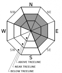
| Ridge Top Winds: | S | SW | SW |
| Wind Speed: | 10 to 15mph with gusts to 35mph. | 15 to 25mph with gusts to 50mph. | 15 to 25mph. Gusts up to 50mph decreasing to 40mph in the afternoon. |
| Expected snowfall: | 0 | 0 | 0 |


