THIS AVALANCHE FORECAST EXPIRED ON December 13, 2017 @ 6:28 am
Avalanche Forecast published on December 12, 2017 @ 6:28 am
Issued by Andy Anderson - Tahoe National Forest - Sierra Avalanche Center

The avalanche danger remains LOW for all elevations today. Some isolated hard wind slabs may still linger in near treeline and above terrain. Triggering these wind slabs has become unlikely, but not impossible for larger triggers or the right trigger on the right slope.  Continue to watch for unstable snow on isolated terrain features.

1. Low

?

Above Treeline
Generally safe avalanche conditions. Watch for unstable snow on isolated terrain features.

1. Low

?

Near Treeline
Generally safe avalanche conditions. Watch for unstable snow on isolated terrain features.

1. Low

?

Below Treeline
Generally safe avalanche conditions. Watch for unstable snow on isolated terrain features.
    Generally safe avalanche conditions. Watch for unstable snow on isolated terrain features.
Avalanche Problem 1: Wind Slab
  • Type ?
  • Aspect/Elevation ?
  • Likelihood ?
    Certain
    Very Likely
    Likely
    Possible
    Unlikely
  • Size ?
    Historic
    Very Large
    Large
    Small

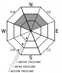
While isolated hard wind slabs may still exist on some wind-loaded slopes, observations and tests indicate that they are becoming increasingly difficult to trigger. The near and above treeline NW aspects represent the most likely places where these isolated wind slabs may still linger, but some may also exist on the few near and above treeline N-NE aspects that were not scoured by the NE/E winds. Triggering these wind slabs has become unlikely but not impossible for larger triggers or the right trigger in the right spot. In the unlikely event that a person does break one of these slabs loose, the slab would break above the person and all around them. Areas where these wind slabs still exist in steep complex terrain like chutes or steep rocky and cliffy slopes and unsupported slopes hold the best potential for an isolated unstable hard wind slab.  

Any avalanche involving this problem could have large consequences due to the numerous obstacles that remain exposed or just barely buried. Avoid slopes where wind slabs may exist. Look for slopes with smooth, wind-sculpted surfaces, and avoid areas with any type of hollow sounding snow. Travelling in sheltered non-wind-affected terrain where softer snow still exists or on snow-covered sun-exposed terrain where spring-like conditions exist should provide safer and more enjoyable conditions today. 

recent observations

* Snow coverage is deepest above 8000' in areas north of Emerald Bay.  Minimal snow coverage exists below 8000'.  In the southern part of the forecast area, less snow exists. Below 8500' snow coverage remains patchy in the southern part of the forecast area. Above 8500 ft. a deeper but highly variable snowpack exists.  Snow coverage is decreasing on southerly aspects at higher elevations. 

* Isolated hard wind slabs with underlying weak snow still exist in some areas. Tests targetting these wind slabs on Castle Peak yesterday yielded inconsistent results. These hard slabs were observed on Needle Peak Ridge (Granite Chief Wilderness), Elephants Back (Carson Pass area) and Relay Peak (Mt. Rose area) during the last week.

* Widespread firm, wind scoured snow surfaces remain on most near and above treeline terrain.

* Variable snow surfaces ranging from softer snow to firm surfaces exist on sheltered near and below treeline northerly terrain.

* Spring-like snow conditions prevail on southerly sun-exposed terrain where snow coverage exists. 

Weather and CURRENT CONDITIONS
weather summary

Temperatures above 8000 ft. and along ridgetops remained above freezing in most locations last night with overnight lows in the upper 30's and low 40's according to sensors this morning. The calm clear weather has allowed cold air to pool in the valleys and lower elevations making them much colder. Remote sensors at the lower elevations reported overnight lows in the teens and 20's. These inversion conditions should continue through at least Thursday. The forecast calls for warm sunny weather during the day and clear nights for the duration of the strong high-pressure ridge ensconced over the forecast area. 

CONDITIONS ALONG THE SIERRA CREST BETWEEN 8200 FT. AND 9200 FT. IN THE LAST 24 HOURS
6am temperature: 36 to 43 deg. F.
Max. temperature: 48 to 54 deg. F.
Average ridgetop wind direction: East
Average ridgetop wind speed: 10 to 15 mph
Maximum ridgetop wind gust: 27 mph
New snowfall: 0 inches
Total snow depth: 15 to 32 inches
Two-Day Mountain Weather Forecast Produced in partnership with the Reno NWS
For 7000 ft. to 8000 ft.
Tuesday Tuesday Night Wednesday
Weather: Sunny Clear Sunny
Temperatures: 46 to 52 deg. F. 24 to 34 deg. F. 48 to 53 deg. F.
Mid Slope Winds: Variable Variable Variable
Wind Speed: Light Light Light
Expected snowfall: 0 0 0
For 8000 ft. to 9000 ft.
Tuesday Tuesday Night Wednesday
Weather: Sunny Clear Sunny
Temperatures: 45 to 50 deg. F. 28 to 36 deg. F. 46 to 51 deg. F.
Ridge Top Winds: Variable Variable East
Wind Speed: Light Light 10 to 15 mph with gusts to 25 mph
Expected snowfall: 0 0 0
Disclaimer

This avalanche advisory is provided through a partnership between the Tahoe National Forest and the Sierra Avalanche Center. This advisory covers the Central Sierra Nevada Mountains between Yuba Pass on the north and Ebbetts Pass on the south. Click here for a map of the forecast area. This advisory applies only to backcountry areas outside established ski area boundaries. This advisory describes general avalanche conditions and local variations always occur. This advisory expires 24 hours after the posted time unless otherwise noted. The information in this advisory is provided by the USDA Forest Service who is solely responsible for its content.

For a recorded version of the Avalanche Advisory call (530) 587-3558 x258