THIS AVALANCHE FORECAST EXPIRED ON December 15, 2017 @ 6:37 am
Avalanche Forecast published on December 14, 2017 @ 6:37 am
Issued by Andy Anderson - Tahoe National Forest - Sierra Avalanche Center

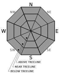
LOW avalanche danger exists at all elevations today. Continue to assess the snowpack and terrain, and travel carefully in the backcountry. Numerous exposed and barely covered obstacles still exist. 

1. Low

?

Above Treeline
Generally safe avalanche conditions. Watch for unstable snow on isolated terrain features.

1. Low

?

Near Treeline
Generally safe avalanche conditions. Watch for unstable snow on isolated terrain features.

1. Low

?

Below Treeline
Generally safe avalanche conditions. Watch for unstable snow on isolated terrain features.
    Generally safe avalanche conditions. Watch for unstable snow on isolated terrain features.
Avalanche Problem 1: Normal Caution
  • Type ?
  • Aspect/Elevation ?
  • Likelihood ?
    Certain
    Very Likely
    Likely
    Possible
    Unlikely
  • Size ?
    Historic
    Very Large
    Large
    Small

Triggering an avalanche has become unlikely. Despite the decrease in avalanche danger, other hazards like numerous exposed rocks, trees, stumps, logs, other obstacles, and widespread firm icy surfaces still remain. Travelling in sheltered non-wind-affected terrain where softer snow still exists or on snow-covered sun-exposed terrain where spring-like conditions exist should provide safer and more enjoyable conditions today.

recent observations

* Areas north of Emerald Bay above 8000 ft, still have decent snow coverage. Below 8000 ft. snow coverage remains patchy and shallow. South of Emerald Bay, less snow exists with areas below 8500 ft. holding very little snow and a deeper but highly variable snowpack in areas above 8500 ft. Snow coverage continues to decrease on southerly aspects at higher elevations. 

* Spring-like snow conditions prevail on southerly sun-exposed terrain where snow coverage exists. Corn snow conditions existed on southerly aspects of Castle Peak and Chickadee Ridge yesterday. 

* Widespread firm, wind scoured snow surfaces remain on most near and above treeline terrain.

* Variable snow surfaces ranging from softer snow to firm surfaces exist on sheltered near and below treeline northerly terrain.

* Tests targetting the isolated hard wind slabs lingering on a few NW aspects no longer yielded unstable results on Andesite Peak yesterday.

Weather and CURRENT CONDITIONS
weather summary

The east and northeast winds increased at the upper elevations overnight. The winds should diminish today and tonight before shifting to the west and increasing again tomorrow. Warm temperatures should continue at the upper elevations and ridges with colder air remaining trapped in the valleys. The forecast calls for more sunny warm days today and tomorrow with highs in the 50's above 7000 ft. Expect the sunny dry weather to continue as long as the high-pressure ridge remains in place.

CONDITIONS ALONG THE SIERRA CREST BETWEEN 8200 FT. AND 9200 FT. IN THE LAST 24 HOURS
6am temperature: 32 to 41 deg. F.
Max. temperature: 51 to 56 deg. F.
Average ridgetop wind direction: East and Northeast
Average ridgetop wind speed: 20 to 30 mph
Maximum ridgetop wind gust: 72 mph
New snowfall: 0 inches
Total snow depth: 15 to 32 inches
Two-Day Mountain Weather Forecast Produced in partnership with the Reno NWS
For 7000 ft. to 8000 ft.
Thursday Thursday Night Friday
Weather: Sunny Clear Sunny
Temperatures: 47 to 52 deg. F. 29 to 37 deg. F. 49 to 54 deg. F.
Mid Slope Winds: Variable Variable Southwest
Wind Speed: Light Light 10 to 15 mph with gusts to 30 mph in the afternoon
Expected snowfall: 0 0 0
For 8000 ft. to 9000 ft.
Thursday Thursday Night Friday
Weather: Sunny Sunny Sunny
Temperatures: 47 to 52 deg. F. 34 to 42 deg. F. 46 to 51 deg. F.
Ridge Top Winds: East Variable West
Wind Speed: 15 to 20 mph with gusts to 60 mph in the morning becoming light in the afternoon Light 15 to 20 mph with gusts to 25 mph increasing to 35 mph in the afternoon
Expected snowfall: 0 0 0
Disclaimer

This avalanche advisory is provided through a partnership between the Tahoe National Forest and the Sierra Avalanche Center. This advisory covers the Central Sierra Nevada Mountains between Yuba Pass on the north and Ebbetts Pass on the south. Click here for a map of the forecast area. This advisory applies only to backcountry areas outside established ski area boundaries. This advisory describes general avalanche conditions and local variations always occur. This advisory expires 24 hours after the posted time unless otherwise noted. The information in this advisory is provided by the USDA Forest Service who is solely responsible for its content.

For a recorded version of the Avalanche Advisory call (530) 587-3558 x258