THIS AVALANCHE FORECAST EXPIRED ON December 29, 2017 @ 6:40 am
Avalanche Forecast published on December 28, 2017 @ 6:40 am
Issued by Andy Anderson - Tahoe National Forest - Sierra Avalanche Center

While avalanches remain unlikely in most areas, the avalanche danger has increased to MODERATE due to a weakening snowpack allowing persistent slab problems to exist in specific areas. Human-triggered avalanches may be possible today in terrain with the right combination of a slab layer resting on top of a persistent weak layer of loose weak snow. This combination does not exist everywhere. Evaluate snow and terrain carefully and identify where slabs may exist on top of a persistent weak layer.

2. Moderate

?

Above Treeline
Heightened avalanche conditions on specific terrain features. Evaluate snow and terrain carefully; identify features of concern.

2. Moderate

?

Near Treeline
Heightened avalanche conditions on specific terrain features. Evaluate snow and terrain carefully; identify features of concern.

2. Moderate

?

Below Treeline
Heightened avalanche conditions on specific terrain features. Evaluate snow and terrain carefully; identify features of concern.
    Heightened avalanche conditions on specific terrain features. Evaluate snow and terrain carefully; identify features of concern.
Avalanche Problem 1: Persistent Slab
  • Type ?
  • Aspect/Elevation ?
  • Likelihood ?
    Certain
    Very Likely
    Likely
    Possible
    Unlikely
  • Size ?
    Historic
    Very Large
    Large
    Small

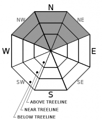
Even though it has not snowed since Dec. 20th, the snowpack continues to change while it sits on the ground. The recent conditions have caused the layer of weak sugary snow (facets) below the surface to grow progressively weaker. In fact, it has grown so weak that in some specific areas where a slab layer exists on top of the persistent weak layer, the weak layer can barely support the snow above it. This combination of slab resting on top of a weak layer does not exist everywhere. In most places, avalanches remain unlikely because either little to no slab exists on top of the persistent weak layer or the weak layer still has enough strength to support the slab above it. In those areas where the combination of slab over persistent weak layer does exist, human triggered avalanches may be possible. These areas include slopes on NW-N-NE aspects where hard wind slabs exist in near and above treeline terrain and some areas in near and below treeline terrain where smaller softer slabs may exist. Persistent slab avalanches can be triggered from the bottom of a slope or other connected slopes. They often break above the person who triggers them and may fail after several people have used a slope. They may not fail until the trigger has fully committed to the slope. 

Clues like whumphing and collapsing, shooting cracks, hollow sounding snow, or digging into the snowpack to find a loose weak layer of snow below a harder layer of snow can indicate that persistent slab avalanche conditions may exist. These clues may be difficult to find and the slope avalanching may be the first clue of a persistent slab problem. Despite the fact that these kinds of avalanches should remain small, they could still have serious consequences in areas with terrain traps or if they carried a person into/over any of the numerous shallowly buried or exposed obstacles. Avoid steep slopes where slabs may exist on top of loose weak snow. Choosing sheltered terrain where no slabs exist will avoid this problem and provide softer snow to recreate on.

recent observations

* Whumphing has occurred on Black Butte (near Carson Pass), on Deep Creek Peak (north of Squaw), and on Silver Peak (also north of Squaw) in the last 3 days as the additional weight of a skier caused the persistent weak layer to collapse below a slab. Tests also yielded unstable results on Rubicon Peak in areas where hard wind slabs sat on top of a layer of weak sugary snow. The layer of weak sugar snow (persistent weak layer of facets) exists on many northerly aspects, but little to no slab layer exists above this weak layer in most places. The signs of instability have remained limited to areas where the right combination of a slab layer resting on top of the persistent weak layer exists.

* Variable snow surface conditions ranging from wind scoured snow and firm icy crusts on exposed slopes to some lingering areas of soft unconsolidated snow on sheltered below treeline northerly aspects exist.

* Northerly facing terrain above 8000 ft in the Mt. Rose area and along the Sierra Crest north of Emerald Bay holds the best snow coverage. Overall less snow cover exists south of Emerald Bay, but decent coverage exists above 8,500 ft. on northerly aspects. Coverage becomes patchy on other aspects and large areas of bare ground exist on many southerly aspects at all elevations.

Weather and CURRENT CONDITIONS
weather summary

The calm clear night allowed cold air to pool in the valleys overnight. While temperatures may have fallen into the upper 20's and low 30's at many of the lower elevations, the ridgetops and upper elevations remained warm overnight. Many of the remote sensors above 8000 ft. reported temperatures in the 40's this morning. The high-pressure ridge will keep the weather dry and sunny until it departs. The forecast calls for even warmer days today and tomorrow with highs above 7000 ft. in the low to mid 50's. Expect some increased cloud cover and increased southwest winds tonight and tomorrow as a small system passes by to the north of the region.

CONDITIONS ALONG THE SIERRA CREST BETWEEN 8200 FT. AND 9200 FT. IN THE LAST 24 HOURS
6am temperature: 40 to 46 deg. F.
Max. temperature: 44 to 50 deg. F.
Average ridgetop wind direction: West and southwest
Average ridgetop wind speed: 10 to 20 mph
Maximum ridgetop wind gust: 47 mph
New snowfall: 0 inches
Total snow depth: 17 to 33 inches
Two-Day Mountain Weather Forecast Produced in partnership with the Reno NWS
For 7000 ft. to 8000 ft.
Thursday Thursday Night Friday
Weather: Sunny Partly cloudy Partly cloudy
Temperatures: 51 to 56 deg. F. 29 to 35 deg. F. 53 to 58 deg. F.
Mid Slope Winds: Southwest Southwest Southwest
Wind Speed: Light in the morning increasing to 10 mph in the afternoon 10 mph 10 to 20 mph with gusts to 30 mph in the afternoon
Expected snowfall: 0 0 0
For 8000 ft. to 9000 ft.
Thursday Thursday Night Friday
Weather: Sunny Partly cloudy Partly cloudy
Temperatures: 48 to 54 deg. F. 32 to 38 deg. F. 50 to 56 deg. F.
Ridge Top Winds: West Southwest Southwest
Wind Speed: 10 to 20 mph with gusts to 30 mph in the afternoon 15 to 25 mph with gusts to 40 mph 20 to 35 mph with gusts to 50 mph in the morning increasing to 70 mph in the afternoon
Expected snowfall: 0 0 0
Disclaimer

This avalanche advisory is provided through a partnership between the Tahoe National Forest and the Sierra Avalanche Center. This advisory covers the Central Sierra Nevada Mountains between Yuba Pass on the north and Ebbetts Pass on the south. Click here for a map of the forecast area. This advisory applies only to backcountry areas outside established ski area boundaries. This advisory describes general avalanche conditions and local variations always occur. This advisory expires 24 hours after the posted time unless otherwise noted. The information in this advisory is provided by the USDA Forest Service who is solely responsible for its content.

For a recorded version of the Avalanche Advisory call (530) 587-3558 x258