THIS AVALANCHE FORECAST EXPIRED ON December 4, 2017 @ 6:45 am
Avalanche Forecast published on December 3, 2017 @ 6:45 am
Issued by Steve Reynaud - Tahoe National Forest

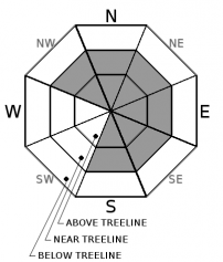
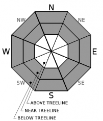
Moderate avalanche danger will exist today as additional snow accumulates with strong to gale force winds.  Human triggered avalanches are possible.  Wind slabs will be possible in near treeline and above treeline terrain.  Storm slabs will be possible in near treeline and below treeline terrain in areas that receive the most storm snow.  Evaluate snow and terrain carefully, identify and avoid features of concern.

2. Moderate

?

Above Treeline
Heightened avalanche conditions on specific terrain features. Evaluate snow and terrain carefully; identify features of concern.

2. Moderate

?

Near Treeline
Heightened avalanche conditions on specific terrain features. Evaluate snow and terrain carefully; identify features of concern.

2. Moderate

?

Below Treeline
Heightened avalanche conditions on specific terrain features. Evaluate snow and terrain carefully; identify features of concern.
    Heightened avalanche conditions on specific terrain features. Evaluate snow and terrain carefully; identify features of concern.
Avalanche Problem 1: Wind Slab
  • Type ?
  • Aspect/Elevation ?
  • Likelihood ?
    Certain
    Very Likely
    Likely
    Possible
    Unlikely
  • Size ?
    Historic
    Very Large
    Large
    Small

Human triggered wind slabs will be possible today on NW-N-NE-E-SE aspects in near treeline and above treeline terrain as additional snow and gale force SW winds continue.  As winds become W today, wind slabs will also become possible on S aspects in near treeline and above treeline terrain.  These wind slabs will continue to grow throughout today and could be capable of producing size D2 avalanches.

Look for blowing snow, cornice formation, and wind pillows as clues to where wind loading is occurring.  Avoid steep wind loaded terrain and runout zones below steep wind loaded terrain.

Avalanche Problem 2: Storm Slab
  • Type ?
  • Aspect/Elevation ?
  • Likelihood ?
    Certain
    Very Likely
    Likely
    Possible
    Unlikely
  • Size ?
    Historic
    Very Large
    Large
    Small

Storm slabs will become possible on all aspects in near treeline and below treeline terrain in areas that receive the most snow today.  The new storm snow could have trouble bonding to the old snow surface which could consist of near surface facets, surface hoar, or firm crusts.  This is not expected to be a widespread avalanche problem, but in areas that receive the most storm snow size D2 avalanches could be possible.

Look for signs of cohesion within the new snow.  Simple hand pits can help you see how the new snow is bonding to the old snow surface.  

recent observations

-Small loose dry avalanche reported on Mt. Houghton

-A usable snowpack exists mainly above 8000', with some snow down to 7500'.

-Near surface facets on most NW-N-NE aspects throughout the forecast area.

-Surface hoar reported throughout area, some evidence of it being destroyed by wind and sun.

-A cohesive and strong snowpack exists below the 11/26 rain crust throughout the forecast region.

Weather and CURRENT CONDITIONS
weather summary

2 to 5'' of new snow overnight with an additional 1 to 4'' likely with 4 to 6'' possible through today.  Gale force SW winds will continue today before changing to W later this afternoon.  As the storm moves east and out of our forecast region, NE winds will develop and increase for Monday and Tuesday as high pressure builds into our area for the week.

CONDITIONS ALONG THE SIERRA CREST BETWEEN 8200 FT. AND 9200 FT. IN THE LAST 24 HOURS
6am temperature: 19 to 27 deg. F.
Max. temperature: 42 deg. F.
Average ridgetop wind direction: SW
Average ridgetop wind speed: 40 to 60 mph
Maximum ridgetop wind gust: 110 mph
New snowfall: 2 to 5 inches
Total snow depth: 15 to 34 inches
Two-Day Mountain Weather Forecast Produced in partnership with the Reno NWS
For 7000 ft. to 8000 ft.
Sunday Sunday Night Monday
Weather: Mostly cloudy then becoming partly cloudy. Snow in the morning, then scattered snow showers in the afternoon. Partly cloudy then becoming clear. Sunny
Temperatures: 27 to 32 deg. F. 12 to 17 deg. F. 26 to 31 deg. F.
Mid Slope Winds: SW shifting to W NE
Wind Speed: 20 to 30mph with gusts to 60mph shifting to the West 15 to 20mph with gusts to 35mph in the afternoon. Light winds 10 to 15 with gusts to 35mph.
Expected snowfall: Likely 1 to 3 in. | Possible 4 to 6 0 0
For 8000 ft. to 9000 ft.
Sunday Sunday Night Monday
Weather: Mostly cloudy then becoming partly cloudy. Snow in the morning, then scattered snow showers in the afternoon. Partly cloudy then becoming clear. Sunny
Temperatures: 23 to 29 deg. F. 10 to 15 deg. F. 23 to 28 deg. F.
Ridge Top Winds: SW shifting to W NE NE
Wind Speed: 30 to 50mph with gusts to 90mph becoming W 20 to 30mph with gusts to 55mph in the afternoon. 15 to 20mph. Gusts up to 40mph decreasing to 30mph after midnight. 20 to 30mph. Gusts to 40mph increasing to 50mph in the afternoon.
Expected snowfall: Likely 1 to 4 in. | Possible 4 to 6 0 0
Disclaimer

This avalanche advisory is provided through a partnership between the Tahoe National Forest and the Sierra Avalanche Center. This advisory covers the Central Sierra Nevada Mountains between Yuba Pass on the north and Ebbetts Pass on the south. Click here for a map of the forecast area. This advisory applies only to backcountry areas outside established ski area boundaries. This advisory describes general avalanche conditions and local variations always occur. This advisory expires 24 hours after the posted time unless otherwise noted. The information in this advisory is provided by the USDA Forest Service who is solely responsible for its content.

For a recorded version of the Avalanche Advisory call (530) 587-3558 x258