THIS AVALANCHE FORECAST EXPIRED ON December 10, 2017 @ 6:54 am
Avalanche Forecast published on December 9, 2017 @ 6:54 am
Issued by Brandon Schwartz - Tahoe National Forest

Hard wind slabs continue to pose a difficult to trigger avalanche problem keeping MODERATE avalanche danger ongoing in some near and above treeline areas. Below treeline, avalanche danger is LOW. These near and above treeline wind slabs are very dense and could allow a person to travel well out onto the slab, becoming fully committed to the slope prior to avalanche occurrence. It is also plausible that several to numerous individuals could travel a slope before the snowpack fails.

2. Moderate

?

Above Treeline
Heightened avalanche conditions on specific terrain features. Evaluate snow and terrain carefully; identify features of concern.

2. Moderate

?

Near Treeline
Heightened avalanche conditions on specific terrain features. Evaluate snow and terrain carefully; identify features of concern.

1. Low

?

Below Treeline
Generally safe avalanche conditions. Watch for unstable snow on isolated terrain features.
    Heightened avalanche conditions on specific terrain features. Evaluate snow and terrain carefully; identify features of concern.
Avalanche Problem 1: Wind Slab
  • Type ?
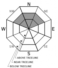
  • Aspect/Elevation ?
  • Likelihood ?
    Certain
    Very Likely
    Likely
    Possible
    Unlikely
  • Size ?
    Historic
    Very Large
    Large
    Small

This avalanche problem is found near and above treeline most prominently on NW aspects. These wind slabs have also been found in very isolated areas on N-NE aspects where the interaction between NE wind and terrain did not result in snow surface scouring. A fair bit of variability for presence or absence of the problem exists around the forecast area, but it continues to show in numerous areas on a regional scale.

This avalanche problem is challenging. Most areas above treeline are very wind affected and it requires a trained eye to differentiate out the areas of hard, mostly smooth wind slab that exist within of the greater areas of wind scoured snow surfaces. Informal evidence of instability is hard to come by, giving little in the way of evidence to aid decision making for the typical recreationist. Don't expect to have much opportunity to see signs of instability in any place other than the snowpit.

If snowpit work and exact slope angle measurements are not solid skills in the tool kit, avoidance is the easiest management technique. Avoid areas of dense wind packed snow. Look for evidence of past drifting, fairly smooth wind sculpted surfaces, and avoid areas with any type of hollow sounding snow. The best snow surface conditions for recreation exist below treeline in areas with both shade and NE wind protection.

This avalanche problem is fueled by the presence of a low density layer of old near surface facets below the hard wind slabs. This hard slab over weak layer is a problematic snowpack structure (see videos and photos of this structure in the observations section).

Slab thickness has been observed to range widely with most of the unstable snowpit data resulting from slabs 6 to 18 inches thick. Human triggered avalanches up to size D2 remain possible.

recent observations

*A couple reports received of human triggered wind slab avalanches this past week.

* Hard wind slabs resting above a weaker layer of older near surface facets have been observed on wind-loaded slopes in the Donner Summit,  Carson Pass, Granite Chief/Needle Pk, and Mount Rose areas. Snowpit tests targeting these stubborn, hard wind slabs continue to show unstable results in some areas.

* Widespread hard wind scoured surfaces exist on exposed N-NE-E aspects. Some areas of firm ice (rain crust) exist at the snow surface in the most heavily wind scoured areas.

* Some areas of unconsolidated snow linger below treeline in shaded areas sheltered from the E and NE winds. These snow surface conditions are becoming increasingly variable due to warming.

Snow coverage is deepest in areas above 8000' in the northern half of the forecast area (north of Emerald Bay). Some areas at the upper elevations south of Emerald Bay have marginal snow coverage. Below 8000', many areas hold patchy snow coverage with exposed obstacles and areas of bare ground. Some exceptions exist with areas of more significant snow cover down to 7,300'.

Weather and CURRENT CONDITIONS
weather summary

High pressure remains firmly in place over the forecast area. Light NE to E flow aloft continues. Inversion conditions are ongoing with nightly air temperatures on the peaks significantly warmer than on the mountain valley floors. Maximum daytime air temperatures will be similar across the elevation spectrum.

CONDITIONS ALONG THE SIERRA CREST BETWEEN 8200 FT. AND 9200 FT. IN THE LAST 24 HOURS
6am temperature: 30 to 38 deg. F.
Max. temperature: 41 to 50 deg. F.
Average ridgetop wind direction: E
Average ridgetop wind speed: 23 mph
Maximum ridgetop wind gust: 37 mph
New snowfall: 0 inches
Total snow depth: 15 to 33 inches
Two-Day Mountain Weather Forecast Produced in partnership with the Reno NWS
For 7000 ft. to 8000 ft.
Saturday Saturday Night Sunday
Weather: Sunny skies. Clear skies. Sunny skies.
Temperatures: 43 to 48 deg. F. 26 to 32 deg. F. 44 to 49 deg. F.
Mid Slope Winds: Variable Variable Variable
Wind Speed: Light winds Light winds Light winds
Expected snowfall: 0 0 0
For 8000 ft. to 9000 ft.
Saturday Saturday Night Sunday
Weather: Sunny skies. Clear skies. Sunny skies.
Temperatures: 41 to 46 deg. F. 30 to 36 deg. F. 43 to 48 deg. F.
Ridge Top Winds: E E E
Wind Speed: Light winds Light winds becoming 10 to 15 mph with gusts to 25 mph after midnight. Light winds becoming 10 to 15 mph with gusts to 25 mph in the afternoon.
Expected snowfall: 0 0 0
Disclaimer

This avalanche advisory is provided through a partnership between the Tahoe National Forest and the Sierra Avalanche Center. This advisory covers the Central Sierra Nevada Mountains between Yuba Pass on the north and Ebbetts Pass on the south. Click here for a map of the forecast area. This advisory applies only to backcountry areas outside established ski area boundaries. This advisory describes general avalanche conditions and local variations always occur. This advisory expires 24 hours after the posted time unless otherwise noted. The information in this advisory is provided by the USDA Forest Service who is solely responsible for its content.

For a recorded version of the Avalanche Advisory call (530) 587-3558 x258