


For 7000 ft. to 8000 ft.
| Wednesday | Wednesday Night | Thursday | |
|---|---|---|---|
| Weather: | Mostly cloudy skies. Snow showers decreasing as the day progresses. | Mostly cloudy skies. Isolated snow showers through the night. | Mostly cloudy skies. Scattered snow showers. |
| Temperatures: | 23 to 28 deg. F. | 6 to 12 deg. F. | 22 to 27 deg. F. |
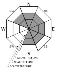
| Mid Slope Winds: | W | W | W |
| Wind Speed: | 15 to 25 mph with gusts to 45 mph. | 15 to 20 mph with gusts to 35 mph. | Light winds. Gusts to 25 mph in the morning. |
| Expected snowfall: | Trace to 3 | Up to 1 | Up to 1 |
For 8000 ft. to 9000 ft.
| Wednesday | Wednesday Night | Thursday | |
|---|---|---|---|
| Weather: | Mostly cloudy skies. Snow showers decreasing as the day progresses. | Mostly cloudy skies. Isolated snow showers through the night. | Mostly cloudy skies. Scattered snow showers. |
| Temperatures: | 19 to 24 deg. F. | 4 to 10 deg. F. | 20 to 26 deg. F. |
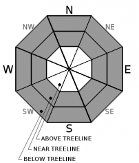
| Ridge Top Winds: | W | W | W |
| Wind Speed: | 20 to 35 mph. Gusts to 75 mph decreasing to 60 mph in the afternoon. | 20 to 30 mph with gusts to 60 mph, decreasing to 15 to 20 mph with gusts to 40 mph after midnight. | 15 to 20 mph. Gusts to 45 mph decreasing to 30 mph in the afternoon. |
| Expected snowfall: | Trace to 3 | Up to 1 | Up to 1 |


