THIS AVALANCHE FORECAST EXPIRED ON February 5, 2017 @ 6:59 am
Avalanche Forecast published on February 4, 2017 @ 6:59 am
Issued by Andy Anderson - Tahoe National Forest - Sierra Avalanche Center

CONSIDERABLE avalanche danger exists on near and above treeline slopes and MODERATE danger exists in below treeline areas. Human triggered wind slab avalanches are likely today and storm slab avalanches are possible. Dangerous avalanche conditions exist. Carefully evaluate the snowpack and terrain before committing to any backcountry route and use this information to choose appropriate terrain that avoids the avalanche problems. 

3. Considerable

?

Above Treeline
Dangerous avalanche conditions. Careful snowpack evaluation, cautious route-finding and conservative decision-making essential.

3. Considerable

?

Near Treeline
Dangerous avalanche conditions. Careful snowpack evaluation, cautious route-finding and conservative decision-making essential.

2. Moderate

?

Below Treeline
Heightened avalanche conditions on specific terrain features. Evaluate snow and terrain carefully; identify features of concern.
    Dangerous avalanche conditions. Careful snowpack evaluation, cautious route-finding and conservative decision-making essential.
Avalanche Problem 1: Wind Slab
  • Type ?
  • Aspect/Elevation ?
  • Likelihood ?
    Certain
    Very Likely
    Likely
    Possible
    Unlikely
  • Size ?
    Historic
    Very Large
    Large
    Small

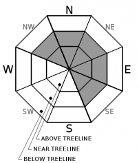
The fragile wind slabs that existed yesterday have grown in size and become more widespread due to more snow and wind during the night. While the best window for natural wind slab avalanches likely occurred last night, human triggered wind slab avalanches remain likely today. These wind slabs most likely exist on exposed near and above treeline wind loaded N-NE-E aspects and cross loaded NW and SE aspects on slopes 35 degrees and steeper. They could measure more than 3 ft. in depth and avalanches involving these wind slabs could have serious consequences.

Use clues like blowing snow, cornices above slopes, wind pillows/drifts, ripples/waves across the snow surface, scoured surfaces, and other wind created textures to help identify where these wind slabs may exist and avoid the wind slabs.

Avalanche Problem 2: Storm Slab
  • Type ?
  • Aspect/Elevation ?
  • Likelihood ?
    Certain
    Very Likely
    Likely
    Possible
    Unlikely
  • Size ?
    Historic
    Very Large
    Large
    Small

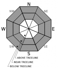
Rising snow levels during the beginning of the storm created an "upside down" snowpack with heavy snow on top of light snow. This light snow can serve as a weak layer with the heavier snow above it serving as a slab layer.  Other changes during the storm may have created other storm snow weaknesses as well. Human triggered storm slab avalanches will remain possible today on any slopes steeper than 35 degrees where new snow exists. 

Digging into the snow to feel for heavy snow on top of lighter snow and clues like recent avalanches or surface cracking can help identify where storm slabs may be an issue. 

recent observations

Yesterday observations on Donner Peak, Tamarack Peak, and Powderhouse Peak all showed dense heavy snow on top of lighter layers of snow and continuous wind transport and wind slab formation on exposed leeward near and above treeline slopes. Wind slabs up to 2 ft in depth had formed on wind loaded slopes by 2 pm. In all three of these locations, tests and observations indicated that the lighter layer of snow formed a weak layer below the heavier layer. In protected areas, fractures did not propagate very well along this weakness. In wind exposed areas where wind loading had created wind slabs, fractures easily propagated along this weakness. Ski cuts and kicks on wind loaded test slopes on Donner Peak triggered shooting cracks in many places with wind slab failures on previously undercut wind loaded test slopes. On Tamarack Peak, ski kicks consistently triggered easy wind slab failures 1-2 ft. in depth.  

Weather and CURRENT CONDITIONS
weather summary

Remote sensors report 10 to 19 inches of new snow in the last 24 hours above 8000 ft. and 4 to 10 inches between 6500 and 8000 ft. Below 6500 ft. most of the precipitation fell as rain. Areas north of Tahoe City reported the most new snow with smaller snow totals south of Tahoe City. Snowfall has tapered off since midnight. Some light snow showers could continue today with up to 2 more inches of snow accumulating during the day. Snow showers should become more isolated tonight and by tomorrow the forecast area should see a break in precipitation. The strong southwest winds should continue through today and decrease some tonight before increasing again tomorrow ahead of another storm system. Daytime highs should remain in the 30's above 7000 ft. today and tomorrow. 

CONDITIONS ALONG THE SIERRA CREST BETWEEN 8200 FT. AND 9200 FT. IN THE LAST 24 HOURS
6am temperature: 26 to 31 deg. F.
Max. temperature: 30 to 33 deg. F.
Average ridgetop wind direction: Southwest
Average ridgetop wind speed: 40 to 60 mph
Maximum ridgetop wind gust: 130 mph
New snowfall: 10 to 19 inches
Total snow depth: 110 to 144 inches
Two-Day Mountain Weather Forecast Produced in partnership with the Reno NWS
For 7000 ft. to 8000 ft.
Saturday Saturday Night Sunday
Weather: Mostly cloudy with scattered snow showers Mostly cloudy with scattered snow showers in the evening. Snow showers becoming isolated after midnight Mostly cloudy with a slight chance of snow showers
Temperatures: 31 to 36 deg. F. 23 to 28 deg. F. 37 to 42 deg. F.
Mid Slope Winds: Southwest Southwest Southwest
Wind Speed: 15 to 30 mph with gusts to 45 mph decreasing to 10 to 20 mph with gusts to 40 mph in the afternoon 10 to 20 mph with gusts to 40 mph 15 to 20 mph with gusts to 40 mph
Expected snowfall: up to 2 up to 1 0
For 8000 ft. to 9000 ft.
Saturday Saturday Night Sunday
Weather: Mostly cloudy with scattered snow showers Mostly cloudy with scattered snow showers in the evening. Snow showers becoming isolated after midnight Mostly cloudy with a slight chance of snow showers
Temperatures: 26 to 31 deg. F. 21 to 26 deg. F. 32 to 38 deg. F.
Ridge Top Winds: Southwest Southwest Southwest
Wind Speed: 30 to 45 mph with gusts to 85 mph decreasing to 25 to 35 mph with gusts to 70 mph in the afternoon 20 to 30 mph with gusts to 70 mph 20 to 35 mph with gusts to 60 mph increasing to 30 to 40 mph with gusts to 85 mph in the afternoon
Expected snowfall: up to 2 up to 1 0
Disclaimer

This avalanche advisory is provided through a partnership between the Tahoe National Forest and the Sierra Avalanche Center. This advisory covers the Central Sierra Nevada Mountains between Yuba Pass on the north and Ebbetts Pass on the south. Click here for a map of the forecast area. This advisory applies only to backcountry areas outside established ski area boundaries. This advisory describes general avalanche conditions and local variations always occur. This advisory expires 24 hours after the posted time unless otherwise noted. The information in this advisory is provided by the USDA Forest Service who is solely responsible for its content.

For a recorded version of the Avalanche Advisory call (530) 587-3558 x258