THIS AVALANCHE FORECAST EXPIRED ON January 3, 2017 @ 7:00 am
Avalanche Forecast published on January 2, 2017 @ 7:00 am
Issued by Andy Anderson - Tahoe National Forest - Sierra Avalanche Center

Human triggered avalanches will be possible today at all elevations due to new wind slabs, new storm slabs, and lingering persistent slabs. Some avalanches could be large and have serious consequences. Evaluate the snowpack and terrain carefully; identify areas where instability may exist, and use this information to avoid those areas of concern. MODERATE avalanche danger exists at all elevations. As more snow and wind impact the region this week, the avalanche danger will increase.

2. Moderate

?

Above Treeline
Heightened avalanche conditions on specific terrain features. Evaluate snow and terrain carefully; identify features of concern.

2. Moderate

?

Near Treeline
Heightened avalanche conditions on specific terrain features. Evaluate snow and terrain carefully; identify features of concern.

2. Moderate

?

Below Treeline
Heightened avalanche conditions on specific terrain features. Evaluate snow and terrain carefully; identify features of concern.
    Heightened avalanche conditions on specific terrain features. Evaluate snow and terrain carefully; identify features of concern.
Avalanche Problem 1: Wind Slab
  • Type ?
  • Aspect/Elevation ?
  • Likelihood ?
    Certain
    Very Likely
    Likely
    Possible
    Unlikely
  • Size ?
    Historic
    Very Large
    Large
    Small

Strong southwest winds and 2 to 6 inches of snowfall overnight mean that fragile wind slabs have started forming on wind-loaded slopes. Wind slabs 1 to 2 ft. in depth could already exist on heavily wind loaded slopes this morning. Wind slabs will become more widespread and larger during the day as more snow accumulates. They could easily grow to 2 to 3 ft in depth in many areas with larger wind slabs in some areas. These wind slabs will form on top of weak old snow and potential buried persistent weak layers mentioned below. Human triggered wind slabs will be possible today and could become likely as more snow accumulates during the next 24 hours.  

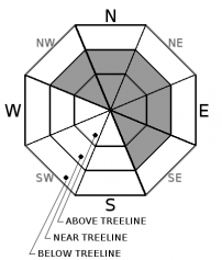
Newly formed wind slabs will exist near treeline and above treeline on NW-N-NE-E-SE aspects on slopes steeper than 35 degrees. Identify where wind slabs exist and use this information to avoid these fragile wind slabs

Avalanche Problem 2: Persistent Slab
  • Type ?
  • Aspect/Elevation ?
  • Likelihood ?
    Certain
    Very Likely
    Likely
    Possible
    Unlikely
  • Size ?
    Historic
    Very Large
    Large
    Small

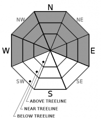
More snow load means that the persistent weak layers near the 12/15 rain crust should become easier to trigger today than they have been for the last 2 days. Human triggered persistent slab avalanches will be possible today. These avalanches could involve all of the snow down to the 12/15 rain crust. Recent observations have shown the persistent weak layers remain weakest along the Sierra Crest on the NW-N-NE aspects but they may still exist on the W and E aspects as well. Some persistent slab avalanches may also become possible in areas where the persistent weak layers are less well developed in places with deeper snowpacks at higher elevations like the Mt. Rose backcountry as new snowfall adds more load to the snowpack. Persistent slabs could exist on slopes 32 degrees and steeper. A great deal of variability exists concerning how much load these layers can support from slope to slope or even across the same slope.

Traditional obvious clues may not provide reliable data for persistent slabs. While digging into the snowpack and snowpit tests can reveal whether or not the persistent weak layers exist, an avalanche can sometimes be the first clue that a slope is unstable. Persistent slabs can break after several people have already used slope when one person finds the right trigger point and propagate farther than expected. They can be triggered remotely or low on a slope and away from the more common ridgetop wind slab start zones. In summary, persistent slab avalanches require different terrain management techniques. Use conservative decision making and travel techniques like traveling on low-angle or well-anchored slopes or sticking to areas where the persistent weak layers do not exist.  

Avalanche Problem 3: Storm Slab
  • Type ?
  • Aspect/Elevation ?
  • Likelihood ?
    Certain
    Very Likely
    Likely
    Possible
    Unlikely
  • Size ?
    Historic
    Very Large
    Large
    Small

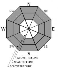
The new snow that accumulates during this storm may not bond well to the current snow surfaces that consist of loose unconsolidated snow. Human triggered storm slab avalanches may be possible in some areas as more snow accumulates today. In some areas where the new snow does not have enough cohesion to behave like a slab layer, some loose dry sluffs may occur. The storm slab avalanches should only involve the new snow in areas where the persistent slabs mentioned above do not exist. In areas where the persistent slabs exist storm slab avalanches could step down and become persistent slab avalanches

recent observations

Yesterday, observations submitted from parties on Andesite Peak (Donner Summit area) and upper Cold Stream Canyon (south of Sugarbowl near Tinkers Knob) still showed a loose weak layer of snow between the 12/15 rain crust and the 12/23-12/24 snow. These parties performed tests on this layer in both those locations and those tests indicated that while the loose weak snow still existed, this layer may have become more difficult to trigger in those areas yesterday. Snow near the surface in these areas remained soft and cold and unconsolidated. Another observation from the backcountry east of Scott Peak near Alpine Meadows showed a mix of light feathery surface hoar and loose weak near surface facets on the snow surface on northerly aspects. Overall observations this week have shown that potential weak layers exist in the snowpack near the 12/15 rain crust and possibly on the snow surface. With new snow loading today and this week, both the new snow/old snow interface and the 12/15 persistent weak layers could be problematic. 

Weather and CURRENT CONDITIONS
weather summary

Strong southwest winds and snowfall started yesterday evening as a cold low-pressure system arrived over the region. So far 2 to 6 inches of snow has accumulated in the mountains around the forecast area with sensors north of Tahoe City reporting 4 to 6 inches of new snow, sensors between Echo Summit and Tahoe City reporting 2 to 4 inches of new snow, and sensors south of Echo Summit reporting closer to 2 inches of new snow. Snowfall and strong southwest winds should continue through tomorrow and spread across the entire forecast area. The forecast calls for an additional 7 to 16 inches of new snow by tomorrow afternoon. Temperatures should remain cold through tonight. The forecast calls for temperatures to warm a few degrees tomorrow as slightly warmer air moves into the region.

CONDITIONS ALONG THE SIERRA CREST BETWEEN 8200 FT. AND 9200 FT. IN THE LAST 24 HOURS
6am temperature: 10 to 15 deg. F.
Max. temperature: 30 to 34 deg. F.
Average ridgetop wind direction: Southwest
Average ridgetop wind speed: 25 to 45 mph
Maximum ridgetop wind gust: 100 mph
New snowfall: 2 to 6 inches
Total snow depth: Along the Sierra Crest 27 to 40 inches | In the Mt. Rose area 58 inches
Two-Day Mountain Weather Forecast Produced in partnership with the Reno NWS
For 7000 ft. to 8000 ft.
Monday Monday Night Tuesday
Weather: Cloudy with snow Cloudy with snow showers Cloudy with snow showers in the morning. Snow becoming more widespread in the afternoon.
Temperatures: 20 to 25 deg. F. 12 to 17 deg. F. 23 to 28 deg. F.
Mid Slope Winds: Southwest Southwest Southwest
Wind Speed: 20 to 30 mph with gusts to 65 mph 20 to 30 mph with gusts to 65 mph decreasing to 55 mph after midnight 10 to 15 mph with gusts to 40 mph
Expected snowfall: 3 to 6 2 to 5 2 to 5
For 8000 ft. to 9000 ft.
Monday Monday Night Tuesday
Weather: Cloudy with snow Cloudy with snow showers Cloudy with snow showers in the morning. Snow becoming more widespread in the afternoon.
Temperatures: 15 to 21 deg. F. 8 to 13 deg. F. 20 to 25 deg. F.
Ridge Top Winds: Southwest Southwest Southwest
Wind Speed: 30 to 45 mph with gusts to 95 mph 30 to 45 mph with gusts to 85 mph decreasing to 75 mph after midnight 20 to 35 mph with gusts to 80 mph
Expected snowfall: 3 to 6 2 to 5 2 to 5
Disclaimer

This avalanche advisory is provided through a partnership between the Tahoe National Forest and the Sierra Avalanche Center. This advisory covers the Central Sierra Nevada Mountains between Yuba Pass on the north and Ebbetts Pass on the south. Click here for a map of the forecast area. This advisory applies only to backcountry areas outside established ski area boundaries. This advisory describes general avalanche conditions and local variations always occur. This advisory expires 24 hours after the posted time unless otherwise noted. The information in this advisory is provided by the USDA Forest Service who is solely responsible for its content.

For a recorded version of the Avalanche Advisory call (530) 587-3558 x258