


For 7000 ft. to 8000 ft.
| Friday | Friday Night | Saturday | |
|---|---|---|---|
| Weather: | Cloudy. Snow. | Cloudy. Snow. | Cloudy. Snow showers in the morning then scattered snow showers in the afternoon. |
| Temperatures: | 25 to 30 deg. F. | 17 to 22 deg. F. | 24 to 29 deg. F. |
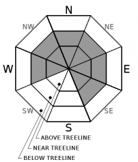
| Mid Slope Winds: | S | SW | SW |
| Wind Speed: | 20 to 30mph with gusts to 60mph. | 15 to 25mph with gusts to 50mph. | 20 to 30mph with gusts to 55mph. |
| Expected snowfall: | 8 to 12 | 5 to 10 | 4 to 8 |
For 8000 ft. to 9000 ft.
| Friday | Friday Night | Saturday | |
|---|---|---|---|
| Weather: | Cloudy. Snow. | Cloudy. Snow. | Cloudy. Scattered snow showers. |
| Temperatures: | 21 to 26 deg. F. | 15 to 20 deg. F. | 20 to 25 deg. F. |
| Ridge Top Winds: | S | SW | SW |
| Wind Speed: | 30 to 45mph. Gusts to 95mph decreasing to 80mph in the afternoon. | 20 to 35mph. Gusts to 70mph decreasing to 60mph after midnight. | 25 to 45mph with gusts to 75mph. |
| Expected snowfall: | 8 to 12 | 5 to 10 | 4 to 8 |


