


For 7000 ft. to 8000 ft.
| Monday | Monday Night | Tuesday | |
|---|---|---|---|
| Weather: | Cloudy with snow showers likely in the morning then a chance of snow showers in the afternoon | Cloudy with a chance of snow showers | Mostly cloudy with a chance of snow showers in the morning. Snow showers decreasing in the afternoon. |
| Temperatures: | 21 to 26 deg. F. | 6 to 16 deg. F. | 22 to 27 deg. F. |
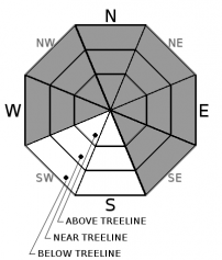
| Mid Slope Winds: | Southwest | Southwest | Variable |
| Wind Speed: | 10 to 15 mph with gusts to 30 mph | 10 to 15 mph with gusts to 30 mph | Light |
| Expected snowfall: | 2 to 4 | up to 1 | 0 |
For 8000 ft. to 9000 ft.
| Monday | Monday Night | Tuesday | |
|---|---|---|---|
| Weather: | Cloudy with snow showers likely in the morning then a chance of snow showers in the afternoon | Cloudy with a chance of snow showers | Mostly cloudy with a chance of snow showers in the morning. Snow showers decreasing in the afternoon. |
| Temperatures: | 17 to 23 deg. F. | 6 to 16 deg. F. | 18 to 23 deg. F. |
| Ridge Top Winds: | Southwest | Southwest | Northeast |
| Wind Speed: | 15 to 25 mph with gusts to 55 mph decreasing to 45 mph in the afternoon | 15 to 25 mph with gusts to 45 mph decreasing to 35 mph in the afternoon | 10 to 15 mph with gusts to 30 mph |
| Expected snowfall: | 2 to 4 | up to 1 | 0 |


