THIS AVALANCHE FORECAST EXPIRED ON January 4, 2017 @ 6:58 am
Avalanche Forecast published on January 3, 2017 @ 6:58 am
Issued by Brandon Schwartz - Tahoe National Forest

CONSIDERABLE avalanche danger at all elevations exists today, increasing to HIGH danger this evening. Human triggered avalanches are likely and natural avalanches are possible. A complex mix of wind slab, storm slab, and deep slab avalanche problems exist. The majority of avalanche activity today is expected on slopes 35 degrees and steeper but could occur on slopes 30 degrees and steeper in isolated areas. An Avalanche Warning has been issued starting 4 pm today lasting through 7 am Thursday.

3. Considerable

?

Above Treeline
Dangerous avalanche conditions. Careful snowpack evaluation, cautious route-finding and conservative decision-making essential.

3. Considerable

?

Near Treeline
Dangerous avalanche conditions. Careful snowpack evaluation, cautious route-finding and conservative decision-making essential.

3. Considerable

?

Below Treeline
Dangerous avalanche conditions. Careful snowpack evaluation, cautious route-finding and conservative decision-making essential.
    Dangerous avalanche conditions. Careful snowpack evaluation, cautious route-finding and conservative decision-making essential.
Avalanche Problem 1: Wind Slab
  • Type ?
  • Aspect/Elevation ?
  • Likelihood ?
    Certain
    Very Likely
    Likely
    Possible
    Unlikely
  • Size ?
    Historic
    Very Large
    Large
    Small

Human triggered wind slab avalanches occurred yesterday in a variety of locations. The ongoing combination of new snow and wind will keep this problem ongoing today. This problem will be most prevalent on NW-N-NE-E-SE aspects in near treeline and above treeline areas, but could be found in more isolated areas on other aspects or below treeline.

Numerous clues such as drifting snow, cornices, and wind pillows exist to identify areas of recent wind loading and subsequent wind slab formation. Identify and avoid areas where wind slabs are likely to exist.

Avalanche Problem 2: Storm Slab
  • Type ?
  • Aspect/Elevation ?
  • Likelihood ?
    Certain
    Very Likely
    Likely
    Possible
    Unlikely
  • Size ?
    Historic
    Very Large
    Large
    Small

New snow from this storm cycle continues to accumulate and is now measured in feet in the majority of locations. Snowpack failure associated with this problem is possible at the old/new snow interface on old near surface facets or anywhere within the storm snow. With warming air temperatures, the storm snow is expected to become increasingly upside down. This avalanche problem will be most prevalent in wind protected near treeline and below treeline areas on all aspects.

Avalanche Problem 3: Deep Slab
  • Type ?
  • Aspect/Elevation ?
  • Likelihood ?
    Certain
    Very Likely
    Likely
    Possible
    Unlikely
  • Size ?
    Historic
    Very Large
    Large
    Small

As new snow continues to increase the load on the snowpack, large persistent slab trending to deep slab avalanches are an increasing concern. The problematic weak layer of near crust facets on top of the Dec 15 rain crust is now buried 2 to 4+ feet deep in the snowpack. Any avalanches that either initially fail on or step down to this weak layer will be large and destructive. Recent snowpit data has shown increasing variability on the degree of weakness in this layer from one location to another, but it is still a problem. This problem is possible on W-NW-N-NE-E aspects above about 7,200', regardless of proximity to treeline.

recent observations

Human triggered wind slab avalanches occurred yesterday on Elephant's Hump (Carson Pass area) and in numerous areas on Castle Peak (Donner Summit area). Avalanche activity was noted to occur either at the old/new snow interface or within the storm snow. On Waterhouse Peak (Luther Pass area), significant blowing snow was observed in open areas near treeline. Areas of wind load that existed yesterday around the forecast area were noted to range from 8 inches to 4 feet. Last night's snowfall will have made these areas even more loaded. Recent snowpit data targeting the persistent weak layer of Dec 15 near crust facets has shown increasing variability in weakness of this layer, but unstable test results continue to occur.

Weather and CURRENT CONDITIONS
weather summary

Ongoing snow showers today are expected to become heavy at times this afternoon. A stronger storm system will arrive this evening and last through Wednesday. Air temperatures started a warming trend overnight, but are still in the teens and 20s. Maximum daytime air temperatures are forecast to reach to mid to upper 20s today above 7,000'. Rising snow levels are expected Wednesday. Ridgetop winds remain gale force out of the SW this morning. Winds are forecast to remain out of the SW today decreasing from gale force to strong in speed. Gale force winds are expected again tonight and tomorrow.

CONDITIONS ALONG THE SIERRA CREST BETWEEN 8200 FT. AND 9200 FT. IN THE LAST 24 HOURS
6am temperature: 17 to 21 deg. F.
Max. temperature: 17 to 21 deg. F.
Average ridgetop wind direction: SW
Average ridgetop wind speed: 51 mph
Maximum ridgetop wind gust: 103 mph
New snowfall: 10 to 20 inches
Total snow depth: Along the Sierra Crest 37 to 44 inches | In the Mt. Rose area 65 inches
Two-Day Mountain Weather Forecast Produced in partnership with the Reno NWS
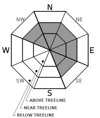
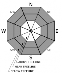
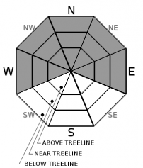
For 7000 ft. to 8000 ft.
Tuesday Tuesday Night Wednesday
Weather: Cloudy skies. Scattered snow showers in the morning. Snow in the afternoon, heavy at times. Cloudy skies with snow. Cloudy skies. Snow through the day with a rain/snow mix possible in the afternoon.
Temperatures: 26 to 31 deg. F. 24 to 29 deg. F. 31 to 36 deg. F.
Mid Slope Winds: SW S SW
Wind Speed: 15 to 20 mph with gusts to 40 mph. 15 to 20 mph with gusts to 40 mph, increasing to 20 to 35 mph with gusts to 70 mph after midnight. 20 to 30 mph with gusts to 50 mph.
Expected snowfall: 4 to 6 10 to 20 8 to 12
For 8000 ft. to 9000 ft.
Tuesday Tuesday Night Wednesday
Weather: Cloudy skies. Scattered snow showers in the morning. Snow in the afternoon, heavy at times. Cloudy skies with snow. Cloudy skies with snow.
Temperatures: 23 to 28 deg. F. 21 to 26 deg. F. 27 to 33 deg. F.
Ridge Top Winds: SW S to SW SW
Wind Speed: 30 to 45 mph with gusts to 80 mph, decreasing to 20 to 30 mph with gusts to 70 mph in the afternoon. 30 to 45 mph with gusts to 85 mph, increasing to 45 to 60 mph with gusts to 100 mph after midnight. 40 to 60 mph with gusts to 105 mph, decreasing to 30 to 45 mph with gusts to 85 mph in the afternoon.
Expected snowfall: 4 to 6 10 to 20 8 to 12
Disclaimer

This avalanche advisory is provided through a partnership between the Tahoe National Forest and the Sierra Avalanche Center. This advisory covers the Central Sierra Nevada Mountains between Yuba Pass on the north and Ebbetts Pass on the south. Click here for a map of the forecast area. This advisory applies only to backcountry areas outside established ski area boundaries. This advisory describes general avalanche conditions and local variations always occur. This advisory expires 24 hours after the posted time unless otherwise noted. The information in this advisory is provided by the USDA Forest Service who is solely responsible for its content.

For a recorded version of the Avalanche Advisory call (530) 587-3558 x258