THIS AVALANCHE FORECAST EXPIRED ON January 5, 2017 @ 6:48 am
Avalanche Forecast published on January 4, 2017 @ 6:48 am
Issued by Brandon Schwartz - Tahoe National Forest

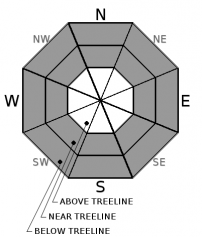
HIGH avalanche danger exists at all elevations today. Natural and human triggered avalanches are likely in a variety of areas. Large destructive avalanches could occur. A complex mix of wind slab, storm slab, and deep slab avalanche problems exist. The majority of avalanche activity today is expected on slopes 35 degrees and steeper but could occur on slopes 30 degrees and steeper in isolated areas. A Backcountry Avalanche Warning is in effect until 7 am Thursday.

4. High

?

Above Treeline
Very dangerous avalanche conditions. Travel in avalanche terrain not recommended.

4. High

?

Near Treeline
Very dangerous avalanche conditions. Travel in avalanche terrain not recommended.

4. High

?

Below Treeline
Very dangerous avalanche conditions. Travel in avalanche terrain not recommended.
    Very dangerous avalanche conditions. Travel in avalanche terrain not recommended.
Avalanche Problem 1: Wind Slab
  • Type ?
  • Aspect/Elevation ?
  • Likelihood ?
    Certain
    Very Likely
    Likely
    Possible
    Unlikely
  • Size ?
    Historic
    Very Large
    Large
    Small

Naturally triggered wind slab avalanches occurred yesterday with indication of easy human triggering of wind slabs in steep wind loaded terrain. Continued new snow and wind will keep this avalanche problem ongoing today. This problem will be most prevalent on NW-N-NE-E-SE aspects in near treeline and above treeline areas, but could be found in more isolated areas on other aspects or below treeline.

Numerous clues such as drifting snow, cornices, and wind pillows exist to identify areas of recent wind loading and subsequent wind slab formation. Identify and avoid areas where wind slabs are likely to exist. Maintin awareness to the proximity of runout zones for natural avalanches on slopes above.

Avalanche Problem 2: Storm Slab
  • Type ?
  • Aspect/Elevation ?
  • Likelihood ?
    Certain
    Very Likely
    Likely
    Possible
    Unlikely
  • Size ?
    Historic
    Very Large
    Large
    Small

Several feet of new snow has accumulated during this storm cycle with more on the way today. Snowpack failure associated with this problem is possible anywhere within the storm snow. With warming air temperatures and rising snow levels last night, the upper third of the storm snow is expected to have developed an upside down structure. This avalanche problem will be most prevalent in wind protected near treeline and below treeline areas on all aspects.

Avalanche Problem 3: Deep Slab
  • Type ?
  • Aspect/Elevation ?
  • Likelihood ?
    Certain
    Very Likely
    Likely
    Possible
    Unlikely
  • Size ?
    Historic
    Very Large
    Large
    Small

Enough snow has been added to the snowpack to create the possibility of deep slab avalanches failing 3 to 7+ feet deep in the snowpack. Weak layers of concern are old near surface facets at the base of the storm snow and more well developed facets down at the Dec 15 rain crust. Any avalanches that either initially fail on or step down to these weak layers will be large and destructive and could run into mature forest. This deep slab avalanche problem is possible on W-NW-N-NE-E aspects above about 7,200', regardless of proximity to treeline. Deep slabs are not impossible in isolated areas on SE-S-SW aspects due to the depth of new snow accumulation.

recent observations

Avalanche activity was reported yesterday from Andesite Peak (Donner Summit area) and from Rose Knob Peak (Mount Rose area). Wind slab and storm slab avalanches occurred with crown depths of 6 inches to 2 feet. Snowpit data continues to point to two areas of instability deeper in the snowpack, one at the base of the storm snow on the old/new interface and the other down on near crust facets around the Dec 15 rain crust. In many areas the old near surface facets at the old/new snow interface are 3+ feet down in the snowpack. Recent snowpit data has shown increasing variability on the degree of weakness in the Dec 15 facet layer from one location to another, but it is still a problem. Yesterday on Andesite Peak, steeping off of skis to dig a snowpit triggered a large collapse, likely on the Dec 15 facets about 4.5 feet down in the snowpack at that location.

Weather and CURRENT CONDITIONS
weather summary

A strong storm system continues to push through the forecast area. Snow levels peaked around 7,500' overnight and have lowered back to around 6,000' this morning. High intensity snowfall is forecast to continue today before tapering in intensity this evening. The day to day warming trend will continue today before the next cold front arrives this evening. Ridgetop winds remain gale force out of the SW. Gale force winds are forecast to continue through today before tapering to strong in speed tonight into tomorrow.

CONDITIONS ALONG THE SIERRA CREST BETWEEN 8200 FT. AND 9200 FT. IN THE LAST 24 HOURS
6am temperature: 25 to 31 deg. F.
Max. temperature: 29 to 33 deg. F.
Average ridgetop wind direction: SW
Average ridgetop wind speed: 61 mph
Maximum ridgetop wind gust: 140 mph
New snowfall: 11 to 20 inches
Total snow depth: Along the Sierra Crest 42 to 62 inches | In the Mt. Rose area 77 inches
Two-Day Mountain Weather Forecast Produced in partnership with the Reno NWS
For 7000 ft. to 8000 ft.
Wednesday Wednesday Night Thursday
Weather: Cloudy skies with snow. Cloudy skies with snow. Cloudy skies with snow in the morning. Snow likely in the afternoon.
Temperatures: 31 to 36 deg. F. 23 to 29 deg. F. 22 to 28 deg. F.
Mid Slope Winds: SW SW SW
Wind Speed: 20 to 30 mph with gusts to 55 mph. 15 to 25 mph with gusts to 55 mph. Gusts decreasing to 40 mph after midnight. 15 to 20 mph with gusts to 30 mph. Gusts increasing to 50 mph in the afternoon.
Expected snowfall: 10 to 18 4 to 8 2 to 5
For 8000 ft. to 9000 ft.
Wednesday Wednesday Night Thursday
Weather: Cloudy skies with snow. Cloudy skies with snow. Cloudy skies with snow.
Temperatures: 27 to 33 deg. F. 19 to 27 deg. F. 15 to 23 deg. F.
Ridge Top Winds: SW SW SW
Wind Speed: 45 to 60 mph with gusts to 100 mph, decreasing to 30 to 50 mph with gusts to 80 mph in the afternoon. 30 to 45 mph, decreasing to 25 to 35 mph after midnight. Gusts up to 80 mph. 20 to 30 mph, increasing to 30 to 45 mph in the afternoon. Gusts up to 60 mph.
Expected snowfall: 10 to 18 4 to 8 2 to 5
Disclaimer

This avalanche advisory is provided through a partnership between the Tahoe National Forest and the Sierra Avalanche Center. This advisory covers the Central Sierra Nevada Mountains between Yuba Pass on the north and Ebbetts Pass on the south. Click here for a map of the forecast area. This advisory applies only to backcountry areas outside established ski area boundaries. This advisory describes general avalanche conditions and local variations always occur. This advisory expires 24 hours after the posted time unless otherwise noted. The information in this advisory is provided by the USDA Forest Service who is solely responsible for its content.

For a recorded version of the Avalanche Advisory call (530) 587-3558 x258