THIS AVALANCHE FORECAST EXPIRED ON January 9, 2017 @ 7:00 am
Avalanche Forecast published on January 8, 2017 @ 7:00 am
Issued by Andy Anderson - Tahoe National Forest - Sierra Avalanche Center

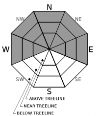
Natural and human triggered avalanches are certain today due to the significant amount of rain on snow expected below 9300 ft. and heavy wet snow loading above 9000 ft. Large, deep, destructive wet slab, deep slab, and wind slab avalanches will occur today as well as loose wet avalanches. Avalanches could run farther than expected and involve almost the entire snowpack. Avoid travel in or near avalanche terrain or runout zones today. EXTREME avalanche danger exists at all elevations. 

5. Extreme

?

Above Treeline
Avoid all avalanche terrain.

5. Extreme

?

Near Treeline
Avoid all avalanche terrain.

5. Extreme

?

Below Treeline
Avoid all avalanche terrain.
    Avoid all avalanche terrain.
Avalanche Problem 1: Wet Slab
  • Type ?
  • Aspect/Elevation ?
  • Likelihood ?
    Certain
    Very Likely
    Likely
    Possible
    Unlikely
  • Size ?
    Historic
    Very Large
    Large
    Small

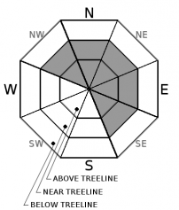
1.5 to 3.5 inches of rain in the last 24 hours combined with an addition 3 to 5 inches of rain forecasted during the day today and another 1-3 inches of rain in some areas tonight will add a huge load to the snowpack. This rain will also weaken the snowpack as it melts the bonds holding the snowpack together. The combination of significant loading, weakening, and rapid warming means that natural and human triggered wet slab avalanches will be very likely to certain today. These avalanches could occur on any aspect, run farther than expected, and could be large and destructive involving most of the snowpack especially in areas where the deep slabs mentioned below exist. Wet slab avalanches can start and run on less steep slopes. In addition to wet slab avalanches, widespread loose wet avalanches should also occur today. 

Avalanche Problem 2: Deep Slab
  • Type ?
  • Aspect/Elevation ?
  • Likelihood ?
    Certain
    Very Likely
    Likely
    Possible
    Unlikely
  • Size ?
    Historic
    Very Large
    Large
    Small

Heavy rain and snow will add a very large amount of weight to the snowpack and make it easier for the facets near the 12/15 rain crust to fail. Natural and human triggered deep slab avalanches due to the failure of this layer are very likely to certain today on W-NW-N-NE-E aspects at all elevations. These avalanches will be large, very deep, and destructive. They could also run much farther than expected. 

Deep slabs are unpredictable. Remote triggering with large propagation into any connected terrain remains possible. Ski tracks on a slope will not be an indicator of stability and steep trees will not be a safe zone. Avoiding any terrain where this problem might exist represents the wisest choice for today. Deep slabs can occur on less steep slopes and any slopes steeper than 30 degrees are suspect. 

Avalanche Problem 3: Wind Slab
  • Type ?
  • Aspect/Elevation ?
  • Likelihood ?
    Certain
    Very Likely
    Likely
    Possible
    Unlikely
  • Size ?
    Historic
    Very Large
    Large
    Small

Above snow line where the precipitation falls as snow, strong southwest winds and heavy wet snow will keep adding to the wind slabs that started forming yesterday. Natural and human-triggered large, deep, destructive wind slab avalanches are very likely today on wind loaded slopes. These wind slab avalanches could also step down and become the deep slabs mentioned above.

recent observations

Freezing levels rose much faster than expected yesterday and rain started falling up to 9000 ft. in some areas by mid-day. Reports of loose wet avalanches occurring around 9:30 am. In the Tamarack Peak area new snow accumulation and strong winds had formed 6-18 inch wind slabs and huge cornices above wind loaded slopes by mid-day. 2 wind slabs that failed during the morning when cornice pieces fell onto the slopes below them were observed along the far east ridge of Tamarack Peak. Hand pits and other observations showed that the heavy new snow was resting on top of a lighter layer of old snow. Ski cuts and kicks on wind loaded test slopes produced limited cracking. Active wind loading continued in this area all day. 

Weather and CURRENT CONDITIONS
weather summary

Snow levels rose more quickly than forecasted during the day yesterday then moved up and down during the day and overnight. Some areas between 8000 and 9000 ft. received 5 to 13 inches of heavy wet snow with some places below 8000 ft. even seeing some snow. However, most of the precipitation below 8000 ft. fell as rain and even in the 8000 to 9000 ft. range much of the precipitation fell as rain. So far about 1.5 to 3.5 inches of water has fallen since yesterday morning. Snow levels should stabilize at between 9000 and 9500 ft. today and more intense heavy rain is expected during the day today. The forecast calls for 3 to 5 inches of rain below 9000 ft. today with 15 to 30 inches of heavy wet snow above 9000 ft. Precipitation should continue tonight but the intensity should start to decrease tonight. Snow levels should also start to fall and rain should change over to mostly snow above 7000 ft. after midnight. The forecast calls for another 1 to 3 inches precip tonight with most of that falling as snow above 8000 ft. (18 to 28 inches) and a mix of rain and snow below 8000 ft. (snow: 4 to 10 in. - rain: 1.5 to 2.5 in). By tomorrow colder temperatures should prevail and snow levels should drop below lake level. Snowfall will continue with the forecast calling for another 6 to 12 inches of new snow during the day tomorrow. Gale force southwest winds should continue through tomorrow with ridgetop gusts in the 90 to 115 mph range and sustained wind speeds in the 45 to 65 mph range. 

CONDITIONS ALONG THE SIERRA CREST BETWEEN 8200 FT. AND 9200 FT. IN THE LAST 24 HOURS
6am temperature: 31 to 34 deg. F.
Max. temperature: 34 to 37 deg. F.
Average ridgetop wind direction: Southwest
Average ridgetop wind speed: 45 to 55 mph
Maximum ridgetop wind gust: 122 mph
New snowfall: Snow: 5 to 13 inches | Rain 1 to 3.6 inches
Total snow depth: Along the Sierra Crest: 48 to 71 inches | In the Mt. Rose area: 92 inches
Two-Day Mountain Weather Forecast Produced in partnership with the Reno NWS
For 7000 ft. to 8000 ft.
Sunday Sunday Night Monday
Weather: Heavy rain. Snow level 9000-9500 ft. Heavy rain changing to snow. Snow levels falling to around 7000 ft. or lower overnight. Snow. Snow levels near 6000 to 7000 ft. in the morning and falling to below 6000 ft. during the day.
Temperatures: 40 to 45 deg. F. 28 to 33 deg. F. 24 to 34 deg. F.
Mid Slope Winds: South Southwest Southwest
Wind Speed: 20 to 30 mph with gusts to 55 mph 20 to 30 mph with gusts to 55 mph 20 to 35 mph with gusts to 50 mph
Expected snowfall: Rain: 3 to 5 Snow: 4 to 10 in. | Rain: 1.5 to 2.5 6 to 12
For 8000 ft. to 9000 ft.
Sunday Sunday Night Monday
Weather: Heavy rain and snow. Snow level ~9000-9500 ft. Heavy snow with a mix of some rain in the evening. Snow levels falling to around 7000 ft. or lower overnight. Snow
Temperatures: 37 to 42 deg. F. 24 to 29 deg. F. 26 to 32 deg. F.
Ridge Top Winds: Southwest Southwest Southwest
Wind Speed: 45 to 65 mph with gusts to 105 mph increasing to 115 mph in the afternoon 45 to 65 mph with gusts to 115 mph decreasing to 35 to 50 mph with gusts to 85 mph after midnight 30 to 50 mph with gusts to 90 mph
Expected snowfall: Snow above 9000 ft: 15 to 30 in. | Rain below 9000 ft: 3 to 5 18 to 28 6 to 12
Disclaimer

This avalanche advisory is provided through a partnership between the Tahoe National Forest and the Sierra Avalanche Center. This advisory covers the Central Sierra Nevada Mountains between Yuba Pass on the north and Ebbetts Pass on the south. Click here for a map of the forecast area. This advisory applies only to backcountry areas outside established ski area boundaries. This advisory describes general avalanche conditions and local variations always occur. This advisory expires 24 hours after the posted time unless otherwise noted. The information in this advisory is provided by the USDA Forest Service who is solely responsible for its content.

For a recorded version of the Avalanche Advisory call (530) 587-3558 x258