THIS AVALANCHE FORECAST EXPIRED ON March 12, 2017 @ 7:56 am
Avalanche Forecast published on March 11, 2017 @ 6:56 am
Issued by Andy Anderson - Tahoe National Forest - Sierra Avalanche Center

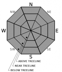
LOW avalanche danger exists this morning. The avalanche danger will increase to MODERATE as loose wet avalanches become possible due to daytime warming and intense spring sunshine. Evaluate snow and terrain carefully and move to less steep slopes or slopes with colder more frozen snow once signs of loose wet instabilities like roller balls, pinwheels, or sinking above your boots into wet snow start to occur. 

2. Moderate

?

Above Treeline
Heightened avalanche conditions on specific terrain features. Evaluate snow and terrain carefully; identify features of concern.

2. Moderate

?

Near Treeline
Heightened avalanche conditions on specific terrain features. Evaluate snow and terrain carefully; identify features of concern.

2. Moderate

?

Below Treeline
Heightened avalanche conditions on specific terrain features. Evaluate snow and terrain carefully; identify features of concern.
    Heightened avalanche conditions on specific terrain features. Evaluate snow and terrain carefully; identify features of concern.
Avalanche Problem 1: Loose Wet
  • Type ?
  • Aspect/Elevation ?
  • Likelihood ?
    Certain
    Very Likely
    Likely
    Possible
    Unlikely
  • Size ?
    Historic
    Very Large
    Large
    Small

Today's intense sunshine and daytime temperatures in the 50's above 7000 ft. should quickly melt through last night's refreeze. Once the refreeze melts, loose wet instabilities like roller balls, pinwheels, and loose point release avalanches could become possible again today. While most of these may remain small, some of them could still entrain enough wet snow to cause problems for backcountry travelers. The steep sun-exposed E-SE-S-SW-W aspects hold the best potential for the largest and most widespread loose wet snow instabilities, but some smaller more isolated loose wet instabilities could also occur on some northerly aspects that receive sunshine. 

Clues like roller balls, pinwheels, and sinking into wet snow above your boot-tops can indicate that larger loose wet avalanches could occur. Avoid steep slopes where wet snow exists today.  

recent observations

Shin-deep wet snow existed on the E-SE-S-SW-W aspects on Castle Peak up to at least 8400 ft. and in Negro Canyon yesterday. This wet snow had not transitioned to corn and was sticky and unsupportable. Ski cuts and kicks on steep E-SE facing slopes in Negro Canyon triggered roller balls and pinwheels up 2 ft. in diameter. In both of these areas, some more supportable snow existed on the slopes that had been heavily wind scoured during the last storm. 

Weather and CURRENT CONDITIONS
weather summary

A high-pressure ridge over the region will keep the weather warm and dry. Expect sunny skies, well above average temperatures, and light winds across the forecast area today and tomorrow. The forecast calls for daytime highs in the mid 50's above 7000 ft. today and tomorrow with overnight lows near freezing. Some minor cloud cover could develop over part of the region today as a small system moves through the Pacific Northwest.

CONDITIONS ALONG THE SIERRA CREST BETWEEN 8200 FT. AND 9200 FT. IN THE LAST 24 HOURS
6am temperature: 31 to 41 deg. F.
Max. temperature: 44 to 53 deg. F.
Average ridgetop wind direction: Southwest and northeast
Average ridgetop wind speed: 10 mph
Maximum ridgetop wind gust: 35 mph
New snowfall: 0 inches
Total snow depth: 130 to 184 inches
Two-Day Mountain Weather Forecast Produced in partnership with the Reno NWS
For 7000 ft. to 8000 ft.
Saturday Saturday Night Sunday
Weather: Sunny with a few clouds later today Partly cloudy becoming clear overnight Sunny
Temperatures: 51 to 56 deg. F. 27 to 33 deg. F. 52 to 57 deg. F.
Mid Slope Winds: Variable Variable Variable
Wind Speed: Light Light Light
Expected snowfall: 0 0 0
For 8000 ft. to 9000 ft.
Saturday Saturday Night Sunday
Weather: Sunny with a few clouds later today Partly cloudy becoming clear overnight Sunny
Temperatures: 48 to 54 deg. F. 28 to 33 deg. F. 49 to 55 deg. F.
Ridge Top Winds: Southwest West Variable
Wind Speed: 10 to 15 mph with gusts to 25 mph increasing to gusts to 35 mph in the afternoon 10 to 15 mph with gusts to 40 mph Light winds with gusts to 25 mph in the morning
Expected snowfall: 0 0 0
Disclaimer

This avalanche advisory is provided through a partnership between the Tahoe National Forest and the Sierra Avalanche Center. This advisory covers the Central Sierra Nevada Mountains between Yuba Pass on the north and Ebbetts Pass on the south. Click here for a map of the forecast area. This advisory applies only to backcountry areas outside established ski area boundaries. This advisory describes general avalanche conditions and local variations always occur. This advisory expires 24 hours after the posted time unless otherwise noted. The information in this advisory is provided by the USDA Forest Service who is solely responsible for its content.

For a recorded version of the Avalanche Advisory call (530) 587-3558 x258