THIS AVALANCHE FORECAST EXPIRED ON March 14, 2017 @ 6:50 am
Avalanche Forecast published on March 13, 2017 @ 6:50 am
Issued by Steve Reynaud - Tahoe National Forest

Low avalanche danger will exist this morning.  As daytime warming occurs, avalanche danger will quickly rise to Moderate due to a loose wet avalanche problem at all elevations.  Look for signs of instability and avoid slopes that have unsupportable snow.

2. Moderate

?

Above Treeline
Heightened avalanche conditions on specific terrain features. Evaluate snow and terrain carefully; identify features of concern.

2. Moderate

?

Near Treeline
Heightened avalanche conditions on specific terrain features. Evaluate snow and terrain carefully; identify features of concern.

2. Moderate

?

Below Treeline
Heightened avalanche conditions on specific terrain features. Evaluate snow and terrain carefully; identify features of concern.
    Heightened avalanche conditions on specific terrain features. Evaluate snow and terrain carefully; identify features of concern.
Avalanche Problem 1: Loose Wet
  • Type ?
  • Aspect/Elevation ?
  • Likelihood ?
    Certain
    Very Likely
    Likely
    Possible
    Unlikely
  • Size ?
    Historic
    Very Large
    Large
    Small

Mostly clear overnight skies but with warmer temperatures than the previous night should create a partial refreeze of the snow surface.  Daytime temperatures are forecasted to be 10 to 15 degrees above average in the high 50's to low 60' above 7000'.  Loose wet activity will become possible as rapid warming and intense sunshine occur on all aspects and elevations.  If SW winds increase this afternoon, they could help to limit the extent of loose wet activity at higher elevations.

Look for clues like roller balls, rapid warming, pinwheels, and deep unsupportable snow-these may indicate that larger loose wet avalanches are becoming more likely.  Terrain traps can increase the consequences of small loose wet activity.    

recent observations

Observations were made and received from Slide Mountain (Mt. Rose area) and Negro Canyon (Donner Summit area).  Both areas reported good overnight refreezes of the snow surface with thick melt freeze crusts.  These melt freeze crusts were ski supportable well into the mid day hours with good spring snow conditions.  No recent loose wet activity was reported from either area.

Weather and CURRENT CONDITIONS
weather summary

Warm spring like weather will continue with temperatures around lake level in the mid 60's and above 7000' in the high 50's to low 60's.  Sierra Crest sensors were reporting temperatures in the low to mid 40's overnight, 7 to 8 degrees warmer than the previous night.  Increasing clouds and wind will occur Wednesday as a storm moves past our area to the north.  A change in the weather is possible for next weekend.

CONDITIONS ALONG THE SIERRA CREST BETWEEN 8200 FT. AND 9200 FT. IN THE LAST 24 HOURS
6am temperature: 39 to 46 deg. F.
Max. temperature: 60 deg. F.
Average ridgetop wind direction: SW
Average ridgetop wind speed: 5 to 15 mph
Maximum ridgetop wind gust: 26 mph
New snowfall: 0 inches
Total snow depth: 126 to 181 inches
Two-Day Mountain Weather Forecast Produced in partnership with the Reno NWS
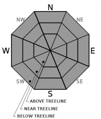
For 7000 ft. to 8000 ft.
Monday Monday Night Tuesday
Weather: Sunny Clear Sunny
Temperatures: 55 to 61 deg. F. 26 to 34 deg. F. 55 to 61 deg. F.
Mid Slope Winds: SW
Wind Speed: Light winds. Light winds. 10 to 15mph with gusts to 30mph in the afternoon.
Expected snowfall: 0 0 0
For 8000 ft. to 9000 ft.
Monday Monday Night Tuesday
Weather: Sunny Clear Sunny
Temperatures: 52 to 58 deg. F. 29 to 35 deg. F. 50 to 58 deg. F.
Ridge Top Winds: SW SW SW
Wind Speed: 10 to 15mph with gusts to 35mph in the afternoon. 10 to 15mph with gusts to 35mph. 15 to 20mph. Gust to 35mph increasing to 45mph in the afternoon.
Expected snowfall: 0 0 0
Disclaimer

This avalanche advisory is provided through a partnership between the Tahoe National Forest and the Sierra Avalanche Center. This advisory covers the Central Sierra Nevada Mountains between Yuba Pass on the north and Ebbetts Pass on the south. Click here for a map of the forecast area. This advisory applies only to backcountry areas outside established ski area boundaries. This advisory describes general avalanche conditions and local variations always occur. This advisory expires 24 hours after the posted time unless otherwise noted. The information in this advisory is provided by the USDA Forest Service who is solely responsible for its content.

For a recorded version of the Avalanche Advisory call (530) 587-3558 x258