THIS AVALANCHE FORECAST EXPIRED ON March 23, 2017 @ 6:49 am
Avalanche Forecast published on March 22, 2017 @ 6:49 am
Issued by Brandon Schwartz - Tahoe National Forest

MODERATE avalanche danger at all elevations is expected today for the vast majority of the forecast area. Isolated, highly localized areas could have greater danger. Wind slab, loose wet, and storm slab avalanche problems are expected today. Identify suspect slopes and avoid areas of concern.

2. Moderate

?

Above Treeline
Heightened avalanche conditions on specific terrain features. Evaluate snow and terrain carefully; identify features of concern.

2. Moderate

?

Near Treeline
Heightened avalanche conditions on specific terrain features. Evaluate snow and terrain carefully; identify features of concern.

2. Moderate

?

Below Treeline
Heightened avalanche conditions on specific terrain features. Evaluate snow and terrain carefully; identify features of concern.
    Heightened avalanche conditions on specific terrain features. Evaluate snow and terrain carefully; identify features of concern.
Avalanche Problem 1: Wind Slab
  • Type ?
  • Aspect/Elevation ?
  • Likelihood ?
    Certain
    Very Likely
    Likely
    Possible
    Unlikely
  • Size ?
    Historic
    Very Large
    Large
    Small

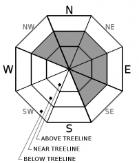
Continued periods of wind and snowfall will build additional winds slabs on top of those that formed yesterday. The vast majority of wind slabs are expected to form near treeline and above treeline on NW-N-NE-E-SE aspects today. Wind slabs could form in isolated areas on S-SW-W aspects as well. Some wind slabs could become increasingly unstable today if sun breaks cause rapid warming of newly formed wind slabs.

Avoid steep slopes where wind drifted snow is accumulating, slopes below cornice features, and steep slopes with recently formed wind pillows.

Avalanche Problem 2: Loose Wet
  • Type ?
  • Aspect/Elevation ?
  • Likelihood ?
    Certain
    Very Likely
    Likely
    Possible
    Unlikely
  • Size ?
    Historic
    Very Large
    Large
    Small

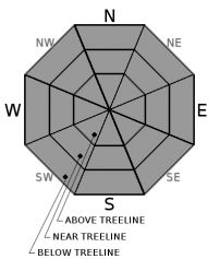
Periods of rapid warming could occur today during sun breaks between convective showers. Natural and human triggered loose wet avalanches could occur on all aspects at all elevations. The spring sun angle is getting high enough to affect NW-N-NE aspects, not just the E-SE-S-SW-W aspects.

Avoid travel on or below steep slopes where roller ball activity is occurring.

Avalanche Problem 3: Storm Slab
  • Type ?
  • Aspect/Elevation ?
  • Likelihood ?
    Certain
    Very Likely
    Likely
    Possible
    Unlikely
  • Size ?
    Historic
    Very Large
    Large
    Small

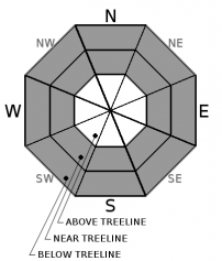
For most areas today that receive the expected 1 to 4 inches of new snowfall, problematic storm slabs are unlikely. Any areas the receive the upper end forecast numbers of 5 to 10 inches of new snow could develop problematic storm slabs. These would be found in wind protected areas near treeline and below treeline on all aspects. Similar to the today's wind slabs, newly formed storm slabs could becoming increasingly unstable if subject to rapid warming during sun breaks.

Look for snow surface cracking while making fresh tracks either uphill or downhill in wind protected areas. Avoid steep slopes in areas where snow surface cracking is occurring.


recent observations

Observations made yesterday on Tamarack Peak (Mount Rose area) revealed accumulating new snow above 8,500' during the morning hours with wind slabs forming near and above treeline. Skier triggered cracking of wind slabs on wind loaded test slopes was very minor. Visibility was too poor to see any signs of natural avalanche activity. Convective snow showers during the afternoon added additional snowfall at lower elevations around much of the forecast area.

Weather and CURRENT CONDITIONS
weather summary

Convective snow showers will continue today for short periods of high intensity snowfall with sun breaks in between convective cells. Thunderstorms are possible again today, especially this afternoon and evening. New snow amounts today are expected to be 1 to 4 inches for the vast majority of locations. Isolated areas that receive multiple convective showers could receive up to 10 inches. Ridgetop winds out of the SSW remain strong to gale force in speed this morning. Winds are forecast to begin decreasing this afternoon, eventually becoming light tomorrow. Short lived high pressure is expected on Thursday for sunny skies. The next storm system is expected to move into the forecast area on Friday.

CONDITIONS ALONG THE SIERRA CREST BETWEEN 8200 FT. AND 9200 FT. IN THE LAST 24 HOURS
6am temperature: 24 to 29 deg. F.
Max. temperature: 32 to 36 deg. F.
Average ridgetop wind direction: SSW
Average ridgetop wind speed: 48 mph
Maximum ridgetop wind gust: 96 mph
New snowfall: 4 to 10 inches
Total snow depth: 125 to 175 inches
Two-Day Mountain Weather Forecast Produced in partnership with the Reno NWS
For 7000 ft. to 8000 ft.
Wednesday Wednesday Night Thursday
Weather: Mostly cloudy with a brief period of heavy snow showers possible this morning. Snow showers with slight chance of thunderstorms and breaks of sunshine in the afternoon. Mostly cloudy. Chance of snow showers and slight chance of thunderstorms in the evening. Slight chance of snow showers after midnight. Partly cloudy skies, becoming sunny.
Temperatures: 28 to 38 deg. F. 20 to 26 deg. F. 38 to 44 deg. F.
Mid Slope Winds: SW W NW
Wind Speed: 10 to 15 mph in the morning, becoming light. Gusts to 30 mph. Light winds with gusts to 25 mph in the evening. Light winds with gusts to 25 mph in the afternoon.
Expected snowfall: Likely 1 to 3 inches | Possibly 4 to 8 Up to 1 0
For 8000 ft. to 9000 ft.
Wednesday Wednesday Night Thursday
Weather: Mostly cloudy with a brief period of heavy snow showers possible this morning. Snow showers with slight chance of thunderstorms and breaks of sunshine in the afternoon. Mostly cloudy. Chance of snow showers and slight chance of thunderstorms in the evening. Slight chance of snow showers after midnight. Partly cloudy skies, becoming sunny.
Temperatures: 26 to 36 deg. F. 18 to 24 deg. F. 35 to 41 deg. F.
Ridge Top Winds: SW W NW
Wind Speed: 20 to 30 mph. Gusts to 80 mph decreasing to 50 mph in the afternoon. 10 to 15 mph in the evening, becoming light. Gusts up to 30 mph. 10 to 15 mph with gusts to 35 mph.
Expected snowfall: Likely 1 to 4 inches | Possibly 5 to 10 Up to 1 0
Disclaimer

This avalanche advisory is provided through a partnership between the Tahoe National Forest and the Sierra Avalanche Center. This advisory covers the Central Sierra Nevada Mountains between Yuba Pass on the north and Ebbetts Pass on the south. Click here for a map of the forecast area. This advisory applies only to backcountry areas outside established ski area boundaries. This advisory describes general avalanche conditions and local variations always occur. This advisory expires 24 hours after the posted time unless otherwise noted. The information in this advisory is provided by the USDA Forest Service who is solely responsible for its content.

For a recorded version of the Avalanche Advisory call (530) 587-3558 x258