THIS AVALANCHE FORECAST EXPIRED ON April 2, 2018 @ 6:50 am
Avalanche Forecast published on April 1, 2018 @ 6:50 am
Issued by Brandon Schwartz - Tahoe National Forest

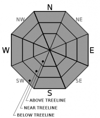
MODERATE avalanche danger will develop at all elevations as a loose wet avalanche problem forms in response to daytime warming. Timing for travel in avalanche terrain is critical. In wet snow conditions, slopes can switch from stable to unstable in as little as 20 minutes.

2. Moderate

?

Above Treeline
Heightened avalanche conditions on specific terrain features. Evaluate snow and terrain carefully; identify features of concern.

2. Moderate

?

Near Treeline
Heightened avalanche conditions on specific terrain features. Evaluate snow and terrain carefully; identify features of concern.

2. Moderate

?

Below Treeline
Heightened avalanche conditions on specific terrain features. Evaluate snow and terrain carefully; identify features of concern.
    Heightened avalanche conditions on specific terrain features. Evaluate snow and terrain carefully; identify features of concern.
Avalanche Problem 1: Loose Wet
  • Type ?
  • Aspect/Elevation ?
  • Likelihood ?
    Certain
    Very Likely
    Likely
    Possible
    Unlikely
  • Size ?
    Historic
    Very Large
    Large
    Small

As daytime warming progresses, loose wet avalanches will become possible at all elevations on E-SE-S-SW-W aspects. Further into the daytime hours, this loose wet avalanche problem will spread to NW-N-NE aspects as well. Avalanche size up to D2 is possible (large enough to bury or injure a person). Identify and avoid avalanche terrain in areas where natural or human triggered roller balls are occurring and/or marginally supportable to unsupportable wet snow exists.

Cloud cover was patchy around the forecast area last night. In locations with above freezing air temperatures overnight, areas of thicker cloud cover will have limited the thickness of snow surface refreeze that formed from radiational cooling. Compare the strength of snow surface refreeze in open areas vs under dense forest canopy. The more discrepancy between the two, the weaker the overall snow surface refreeze in the area of travel. A weaker, thinner snow surface refreeze will give way to unstable wet snow earlier in the day than a stronger, thicker refreeze. Pay close attention to the remaining thickness of surface crust as the day progresses. Once it becomes marginally supportable to unsupportable, the snowpack can quickly become unstable.

recent observations

* Recent observations from around the forecast area have shown increasingly well established melt-freeze conditions on E-SE-S-SW-W aspects. The upper snowpack remains transitional on many NW-N-NE aspects, especially at the upper elevations.

* Snowpit tests performed yesterday on Silver Peak (Pole Creek area) in the crown of one of the numerous deep slab avalanches from March 22 indicated that the associated weak layer continues to retain characteristics that allow for propagation. No signs of current deep slab instability were observed.

Weather and CURRENT CONDITIONS
weather summary

A weather system passing by to the north of the forecast area will increase ridgetop winds this afternoon. Otherwise, expect sunny skies and above average air temperatures for today. A few degrees of cooling are forecast for Monday. Ridgetop winds will decrease Monday afternoon into Tuesday. Generally mild conditions are forecast for much of this week before a warm atmospheric river type storm system impacts the region Friday-Saturday.

CONDITIONS ALONG THE SIERRA CREST BETWEEN 8200 FT. AND 9200 FT. IN THE LAST 24 HOURS
6am temperature: 30 to 41 deg. F.
Max. temperature: 47 to 52 deg. F.
Average ridgetop wind direction: SW
Average ridgetop wind speed: 22 mph
Maximum ridgetop wind gust: 56 mph
New snowfall: 0 inches
Total snow depth: 68 to 105 inches
Two-Day Mountain Weather Forecast Produced in partnership with the Reno NWS
For 7000 ft. to 8000 ft.
Sunday Sunday Night Monday
Weather: Sunny skies. Partly cloudy skies. Partly cloudy skies.
Temperatures: 50 to 56 deg. F. 29 to 34 deg. F. 47 to 53 deg. F.
Mid Slope Winds: SW SW to W W
Wind Speed: 5 to 10 mph, increasing to 10 to 20 mph with gusts to 35 mph. 15 to 20 mph with gusts to 40 mph, decreasing to 10 to 15 mph with gusts to 30 mph after midnight. 10 to 15 mph. Gusts up to 30 mph in the morning.
Expected snowfall: 0 0 0
For 8000 ft. to 9000 ft.
Sunday Sunday Night Monday
Weather: Sunny skies. Partly cloudy skies. Partly cloudy skies.
Temperatures: 43 to 51 deg. F. 28 to 33 deg. F. 39 to 47 deg. F.
Ridge Top Winds: SW to W SW W
Wind Speed: 15 to 25 mph with gusts to 40 mph, increasing to 20 to 30 mph with gusts to 50 mph in the afternoon. 20 to 35 mph with gusts to 55 mph, decreasing to 15 to 25 mph with gusts to 45 mph after midnight. 15 to 25 mph with gusts to 45 mph, decreasing to 10 to 20 mph with gusts to 35 mph in the afternoon.
Expected snowfall: 0 0 0
Disclaimer

This avalanche advisory is provided through a partnership between the Tahoe National Forest and the Sierra Avalanche Center. This advisory covers the Central Sierra Nevada Mountains between Yuba Pass on the north and Ebbetts Pass on the south. Click here for a map of the forecast area. This advisory applies only to backcountry areas outside established ski area boundaries. This advisory describes general avalanche conditions and local variations always occur. This advisory expires 24 hours after the posted time unless otherwise noted. The information in this advisory is provided by the USDA Forest Service who is solely responsible for its content.

For a recorded version of the Avalanche Advisory call (530) 587-3558 x258