


For 7000 ft. to 8000 ft.
| Tuesday | Tuesday Night | Wednesday | |
|---|---|---|---|
| Weather: | Mostly cloudy skies. Scattered rain showers in the afternoon. Snow level 8,500'. | Mostly cloudy skies, becoming partly cloudy. Scattered rain and snow showers in the evening. Snow level 8,000'. | Partly cloudy skies, becoming mostly cloudy. A chance of rain and snow showers in the afternoon. Snow level 7,000' to 7,500'. |
| Temperatures: | 48 to 56 deg. F. | 31 to 36 deg. F. | 40 to 48 deg. F. |
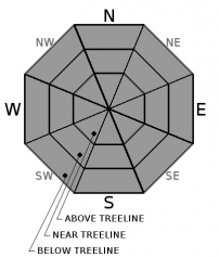
| Mid Slope Winds: | SW | SW | SW |
| Wind Speed: | 15 to 25 mph with gusts to 35 mph, increasing to 20 to 35 mph with gusts to 55 mph in the afternoon. | 20 to 30 mph. Gusts to 60 mph decreasing to 40 mph after midnight. | 15 to 20 mph with gusts to 40 mph, increasing to 20 to 30 mph with gusts to 55 mph in the afternoon. |
| Expected snowfall: | 0 | 0 to 1 | Up to 1 |
For 8000 ft. to 9000 ft.
| Tuesday | Tuesday Night | Wednesday | |
|---|---|---|---|
| Weather: | Mostly cloudy skies. Scattered rain and snow showers in the afternoon. Snow level 8,500'. | Mostly cloudy skies, becoming partly cloudy. Scattered rain and snow showers in the evening. Snow level 8,000'. | Partly cloudy skies, becoming mostly cloudy. A chance of snow showers in the afternoon. Snow level 7,000' to 7,500'. |
| Temperatures: | 43 to 51 deg. F. | 30 to 35 deg. F. | 35 to 43 deg. F. |
| Ridge Top Winds: | S to SW | SW | SW |
| Wind Speed: | 30 to 45 mph with gusts to 70 mph, increasing to 35 to 55 mph with gusts to 90 mph in the afternoon. | 30 to 50 mph with gusts to 80 mph, decreasing to 25 to 35 mph with gusts to 60 mph after midnight. | 25 to 35 mph with gusts to 75 mph, increasing to 30 to 45 mph with gusts to 85 mph in the afternoon. |
| Expected snowfall: | 0 to 1 | Up to 1 | Up to 1 |


