THIS AVALANCHE FORECAST EXPIRED ON April 14, 2018 @ 6:59 am
Avalanche Forecast published on April 13, 2018 @ 6:59 am
Issued by Andy Anderson - Tahoe National Forest - Sierra Avalanche Center

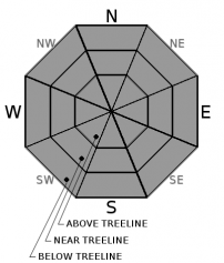
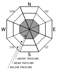
The avalanche danger is MODERATE today. Rapid warming will make loose wet avalanches a more widespread problem today. In addition to the loose wet avalanches that are possible today, some small wind slabs may exist near ridgelines. 

2. Moderate

?

Above Treeline
Heightened avalanche conditions on specific terrain features. Evaluate snow and terrain carefully; identify features of concern.

2. Moderate

?

Near Treeline
Heightened avalanche conditions on specific terrain features. Evaluate snow and terrain carefully; identify features of concern.

2. Moderate

?

Below Treeline
Heightened avalanche conditions on specific terrain features. Evaluate snow and terrain carefully; identify features of concern.
    Heightened avalanche conditions on specific terrain features. Evaluate snow and terrain carefully; identify features of concern.
Avalanche Problem 1: Loose Wet
  • Type ?
  • Aspect/Elevation ?
  • Likelihood ?
    Certain
    Very Likely
    Likely
    Possible
    Unlikely
  • Size ?
    Historic
    Very Large
    Large
    Small

Strong April sun and warm spring weather will cause loose wet instabilities today. Expect to trigger roller balls, pinwheels, and loose wet avalanches on steep slopes. Some small natural loose wet instabilities may occur on the most sun exposed slopes near rocks or trees as well. These loose wet instabilities could involve all of the new snow that fell on Thursday night and would likely slide on the melt-freeze crust below this snow. Most of these should remain relatively small since limited new snow exists in most places, but some could entrain enough snow to cause problems for backcountry travellers or injure a person. Loose wet avalanhces are possible today on any steep slope where new snow exists. 

As soon as the sun hits the new snow today wet snow will start to form on the surface. Conditions can change quickly from cold soft snow to sunny warm unstable snow. Once the snow starts to feel wet and sticky or small signs of loose wet instabilities like small roller balls or pinwheels start to occur, it is time to find a colder aspect or head off the snow for a different afternoon activity.

Avalanche Problem 2: Wind Slab
  • Type ?
  • Aspect/Elevation ?
  • Likelihood ?
    Certain
    Very Likely
    Likely
    Possible
    Unlikely
  • Size ?
    Historic
    Very Large
    Large
    Small

As the winds shifted from SW to W to NE over the last 24 hours, they also redistributed Thursday night's snow. Many N-NE-E aspects should be scoured back to the crust that existed prior to the storm but some may still have a few pockets of small wind slabs on them. Some small wind slabs may also exist on W-SW-S aspects near ridgelines. NW and SE aspects could have a mix of crusts and cross-loaded snow. While wind slab avalanches are unlikely in most areas, some small shallow human-triggered wind slabs may still be possible in isolated areas near ridgelines especially on sun-exposed slopes. 

Clues like cornices above a slope, drifted snow, ripples in the snow surface, and other wind created features can help identify where these small isolated wind slabs may exist.

recent observations

* Yesterday observations on Castle Peak, Andesite Ridge, and Mt. Judah all showed small amounts of new snow resting on top of old frozen crusts. This snow became sun affected and started to become wet on all but the North aspects yesterday.

* Some very small skier triggered wet snow sluffs started to occur on E aspects on Castle and Andesite yesterday morning.

* Minor wind slab instability was noted on Andesite and Castle.

Weather and CURRENT CONDITIONS
weather summary

Winds shifted to the NE last night as a high pressure ridge moved into the area. They should continue this morning, but should subside by this afternoon. The high pressure will also bring back sunny spring weather with daytime highs jumping into the mid to upper 40's above 8000 ft. which is ~15 degrees higher than yesterday. Warming should continue tomorrow with highs possible reaching into the low 50's above 8000 ft. The wind should shift back to the southwest tomorrow with some thin high cloud cover moving into the area. The forecast calls for another cold storm to arrive over the forecast area on Sunday night.

CONDITIONS ALONG THE SIERRA CREST BETWEEN 8200 FT. AND 9200 FT. IN THE LAST 24 HOURS
6am temperature: 18 to 21 deg. F.
Max. temperature: 26 to 31 deg. F.
Average ridgetop wind direction: West shifting to Northeast
Average ridgetop wind speed: 30 mph
Maximum ridgetop wind gust: 60 mph
New snowfall: up to 1 inches
Total snow depth: 52 to 92 inches
Two-Day Mountain Weather Forecast Produced in partnership with the Reno NWS
For 7000 ft. to 8000 ft.
Friday Friday Night Saturday
Weather: Sunny Partly cloudy becoming clear Sunny then becoming partly cloudy
Temperatures: 46 to 51 deg. F. 26 to 31 deg. F. 50 to 56 deg. F.
Mid Slope Winds: Northeast Variable Southwest
Wind Speed: Light with gusts to 30 mph in the morning Light Light in the morning increasing to 10 to 15 mph with gusts to 25 mph in the afternoon
Expected snowfall: 0 0 0
For 8000 ft. to 9000 ft.
Friday Friday Night Saturday
Weather: Sunny Partly cloudy becoming clear Sunny then becoming partly cloudy
Temperatures: 42 to 48 deg. F. 24 to 29 deg. F. 45 to 51 deg. F.
Ridge Top Winds: Northeast Variable Southwest
Wind Speed: 15 to 25 mph with gusts to 45 mph decreasing to 30 mph in the afternoon Light 10 to 15 mph with gusts to 30 mph
Expected snowfall: 0 0 0
Disclaimer

This avalanche advisory is provided through a partnership between the Tahoe National Forest and the Sierra Avalanche Center. This advisory covers the Central Sierra Nevada Mountains between Yuba Pass on the north and Ebbetts Pass on the south. Click here for a map of the forecast area. This advisory applies only to backcountry areas outside established ski area boundaries. This advisory describes general avalanche conditions and local variations always occur. This advisory expires 24 hours after the posted time unless otherwise noted. The information in this advisory is provided by the USDA Forest Service who is solely responsible for its content.

For a recorded version of the Avalanche Advisory call (530) 587-3558 x258