


For 7000 ft. to 8000 ft.
| Saturday | Saturday Night | Sunday | |
|---|---|---|---|
| Weather: | Sunny skies. | Partly cloudy skies, becoming mostly cloudy. | Partly cloudy skies. A slight chance of rain and snow in the afternoon. Snow level 7,000'. |
| Temperatures: | 50 to 56 deg. F. | 31 to 36 deg. F. | 46 to 52 deg. F. |
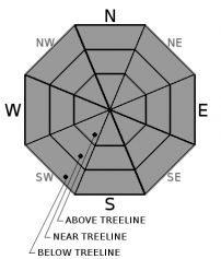
| Mid Slope Winds: | SW | SW | SW |
| Wind Speed: | Light winds, becoming 10 to 15 mph with gusts to 25 mph in the afternoon. | 10 to 15 mph with gusts to 40 mph. | 15 to 25 mph with gusts to 45 mph, increasing to 25 to 35 mph with gusts to 65 mph in the afternoon. |
| Expected snowfall: | 0 | 0 | 0 to trace |
For 8000 ft. to 9000 ft.
| Saturday | Saturday Night | Sunday | |
|---|---|---|---|
| Weather: | Sunny skies. | Partly cloudy skies, becoming mostly cloudy. | Partly cloudy skies. A slight chance of snow in the afternoon. |
| Temperatures: | 46 to 52 deg. F. | 28 to 33 deg. F. | 40 to 46 deg. F. |
| Ridge Top Winds: | SW | SW | SW |
| Wind Speed: | 10 to 15 mph with gusts to 30 mph. | 20 to 30 mph. Gusts to 40 mph increasing to 60 mph after midnight. | 25 to 35 mph with gusts to 70 mph, increasing to 30 to 50 mph with gusts to 80 mph in the afternoon. |
| Expected snowfall: | 0 | 0 | 0 to trace |


