


For 7000 ft. to 8000 ft.
| Sunday | Sunday Night | Monday | |
|---|---|---|---|
| Weather: | Partly cloudy skies. A chance of rain and snow in the afternoon. Snow level 7,500'. | Cloudy skies with snow. | Mostly cloudy skies. Snow showers likely in the morning. Widespread snow showers in the afternoon. |
| Temperatures: | 44 to 50 deg. F. | 19 to 24 deg. F. | 28 to 33 deg. F. |
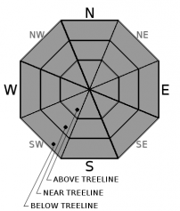
| Mid Slope Winds: | SW | SW | SW |
| Wind Speed: | 15 to 25 mph with gusts to 45 mph, increasing to 25 to 35 mph with gusts to 60 mph in the afternoon. | 20 to 35 mph with gusts to 70 mph, decreasing to 15 to 25 mph with gusts to 60 mph after midnight. | 10 to 15 mph with gusts to 35 mph. |
| Expected snowfall: | Trace to 1 | Likely 4 to 8 in. | Small chance 8 to 12 | Likely 1 to 4 in. | Small chance 4 to 6 |
For 8000 ft. to 9000 ft.
| Sunday | Sunday Night | Monday | |
|---|---|---|---|
| Weather: | Partly cloudy skies. A chance of snow in the afternoon. | Cloudy skies with snow. | Mostly cloudy skies. Snow showers likely in the morning. Widespread snow showers in the afternoon. |
| Temperatures: | 39 to 45 deg. F. | 15 to 20 deg. F. | 22 to 28 deg. F. |
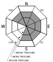
| Ridge Top Winds: | SW | SW | SW |
| Wind Speed: | 25 to 35 mph with gusts to 70 mph, increasing to 30 to 50 mph with gusts to 80 mph in the afternoon. | 35 to 55 mph decreasing to 30 to 45 mph after midnight. Gusts up to 90 mph. | 20 to 30 mph. Gusts up to 60 mph decreasing to 40 mph in the afternoon. |
| Expected snowfall: | Up to 1 | Likely 5 to 10 in. | Small chance 10 to 14 | Likely 1 to 4 in. | Small chance 4 to 6 |


