


For 7000 ft. to 8000 ft.
| Tuesday | Tuesday Night | Wednesday | |
|---|---|---|---|
| Weather: | Sunny | Partly cloudy becoming mostly cloudy | Mostly cloudy with a slight chance of snow showers in the afternoon |
| Temperatures: | 36 to 42 deg. F. | 19 to 24 deg. F. | 36 to 42 deg. F. |
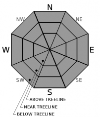
| Mid Slope Winds: | Variable | Variable | Southwest |
| Wind Speed: | Light | Light with gusts to 25 mph after midnight | Light in the morning increasing to 10 to 15 mph with gusts to 35 mph in the afternoon |
| Expected snowfall: | 0 | 0 | trace |
For 8000 ft. to 9000 ft.
| Tuesday | Tuesday Night | Wednesday | |
|---|---|---|---|
| Weather: | Sunny | Partly cloudy becoming mostly cloudy | Mostly cloudy with a slight chance of snow showers in the afternoon |
| Temperatures: | 30 to 36 deg. F. | 17 to 22 deg. F. | 28 to 36 deg. F. |
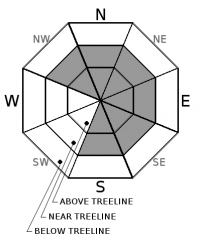
| Ridge Top Winds: | Variable | South | Southwest |
| Wind Speed: | Light | Light increasing to 10 to 15 mph with gusts to to 40 mph after midnight | 20 to 30 mph with gusts to 60 mph |
| Expected snowfall: | 0 | 0 | trace |


