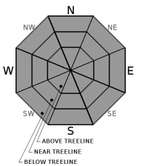
THIS AVALANCHE FORECAST EXPIRED ON April 22, 2018 @ 6:38 am
Avalanche Forecast published on April 21, 2018 @ 6:38 am
Issued by Brandon Schwartz - Tahoe National Forest

Areas of MODERATE avalanche danger will exist today at all elevations as a loose wet avalanche problem occurs in response to daytime warming and snow surface melt. Avoid travel in or below avalanche terrain on slopes with marginally supportable to unsupportable wet snow conditions or on slopes where roller balls are occurring.

2. Moderate

?

Above Treeline
Heightened avalanche conditions on specific terrain features. Evaluate snow and terrain carefully; identify features of concern.

2. Moderate

?

Near Treeline
Heightened avalanche conditions on specific terrain features. Evaluate snow and terrain carefully; identify features of concern.

2. Moderate

?

Below Treeline
Heightened avalanche conditions on specific terrain features. Evaluate snow and terrain carefully; identify features of concern.
    Heightened avalanche conditions on specific terrain features. Evaluate snow and terrain carefully; identify features of concern.
Avalanche Problem 1: Loose Wet
  • Type ?
  • Aspect/Elevation ?
  • Likelihood ?
    Certain
    Very Likely
    Likely
    Possible
    Unlikely
  • Size ?
    Historic
    Very Large
    Large
    Small

A decent to strong snow surface refreeze is expected to have occurred last night from radiational cooling under clear skies despite above freezing overnight air temperatures in many locations. With the April 15-16 storm snow having now gone through melt-freeze in nearly all locations, loose wet avalanche problems are expected to be less widespread today than yesterday. That said, loose wet avalanches could still be triggered by those venturing into steep terrain today while the snow surface is in melt phase. As daytime warming and snow surface melt progresses, loose wet avalanches will become possible on all aspects at all elevations. Avalanche size up to D2 is possible (large enough to bury or injure a person).

Monitor snow surface conditions as the day progresses. Pay attention to supportability of melt-freeze crust at the snow surface. Once melt makes this crust marginally supportable to unsupportable, loose wet avalanches are possible. With the top foot of the snowpack becoming less transitional with every melt-freeze cycle, roller balls will become less prominent as a sign of potentially unstable snow and a loss of supportability will be the primary indicator of potential instability. Avoid travel in or below avalanche terrain on slopes with marginally supportable to unsupportable wet snow conditions or on slopes where roller balls are occurring.

recent observations

* Yesterday, a loose wet avalanche was intentionally triggered by a ski cut on Red Lake Peak (Carson Pass area) on an above treeline E aspect around 9,600' at about 11:30 am. The avalanche ran about 400 vertical feet and the avalanche size was reported at D1.5 (not large enough to bury a person, but could possibly cause injury).

* Yesterday, rapid warming of the April 15-16 storm snow lead to loose wet instability reported on Red Lake Peak (Carson Pass area), Rubicon Peak (West Shore Tahoe area), and on Castle Peak (Donner Summit area). Loose wet instability was noted on all aspects at all elevations.

* Snow cover continues to become thin to nonexistent in the lower elevations of the forecast area. Snow cover improves above 7,200'-8,000' depending on location. Numerous open creeks exist below 8,000'.

Weather and CURRENT CONDITIONS
weather summary

High pressure is in place over the forecast area. Sunny and warm spring weather will occur today with well above average air temperatures expected for the next few days. Calm to light winds today will become light to moderate in speed out of the SW tomorrow as a weather system passes by to the north of the forecast area. Some additional clouds are forecast on Sunday due to the passing weather system.

CONDITIONS ALONG THE SIERRA CREST BETWEEN 8200 FT. AND 9200 FT. IN THE LAST 24 HOURS
6am temperature: 32 to 43 deg. F.
Max. temperature: 49 to 55 deg. F.
Average ridgetop wind direction: NE
Average ridgetop wind speed: 10 mph
Maximum ridgetop wind gust: 39 mph
New snowfall: 0 inches
Total snow depth: 48 to 91 inches
Two-Day Mountain Weather Forecast Produced in partnership with the Reno NWS
For 7000 ft. to 8000 ft.
Saturday Saturday Night Sunday
Weather: Sunny skies. Clear skies. Partly cloudy skies.
Temperatures: 57 to 62 deg. F. 35 to 40 deg. F. 55 to 61 deg. F.
Mid Slope Winds: Variable Variable SW
Wind Speed: Light winds Light winds Light winds increasing to 10 to 15 mph with gusts to 25 mph in the afternoon.
Expected snowfall: 0 0 0
For 8000 ft. to 9000 ft.
Saturday Saturday Night Sunday
Weather: Sunny skies. Clear skies. Partly cloudy skies.
Temperatures: 51 to 57 deg. F. 35 to 41 deg. F. 50 to 56 deg. F.
Ridge Top Winds: Variable Variable SW
Wind Speed: Light winds Light winds 10 to 15 mph with gusts to 30 mph.
Expected snowfall: 0 0 0
Disclaimer

This avalanche advisory is provided through a partnership between the Tahoe National Forest and the Sierra Avalanche Center. This advisory covers the Central Sierra Nevada Mountains between Yuba Pass on the north and Ebbetts Pass on the south. Click here for a map of the forecast area. This advisory applies only to backcountry areas outside established ski area boundaries. This advisory describes general avalanche conditions and local variations always occur. This advisory expires 24 hours after the posted time unless otherwise noted. The information in this advisory is provided by the USDA Forest Service who is solely responsible for its content.

For a recorded version of the Avalanche Advisory call (530) 587-3558 x258