THIS AVALANCHE FORECAST EXPIRED ON April 5, 2018 @ 6:50 am
Avalanche Forecast published on April 4, 2018 @ 6:50 am
Issued by Steve Reynaud - Tahoe National Forest

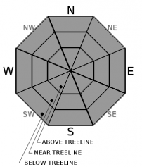
MODERATE avalanche danger will continue as daytime warming occurs due to a loose wet avalanche problem.  Loose wet avalanches will become possible at all elevations today.  Avoid avalanche terrain with unsupportable wet snow.

2. Moderate

?

Above Treeline
Heightened avalanche conditions on specific terrain features. Evaluate snow and terrain carefully; identify features of concern.

2. Moderate

?

Near Treeline
Heightened avalanche conditions on specific terrain features. Evaluate snow and terrain carefully; identify features of concern.

2. Moderate

?

Below Treeline
Heightened avalanche conditions on specific terrain features. Evaluate snow and terrain carefully; identify features of concern.
    Heightened avalanche conditions on specific terrain features. Evaluate snow and terrain carefully; identify features of concern.
Avalanche Problem 1: Loose Wet
  • Type ?
  • Aspect/Elevation ?
  • Likelihood ?
    Certain
    Very Likely
    Likely
    Possible
    Unlikely
  • Size ?
    Historic
    Very Large
    Large
    Small

Loose wet avalanches will become possible on all aspects and elevations as daytime warming occurs.  Warmer overnight temperatures along with increased cloud cover should provide a more marginal overnight refreeze of the snow surface in most locations.  Snow surface supportability could deteriorate more quickly this morning than over the last several days when a better refreeze occurred.  Roller balls, pinwheels, and loose wet avalanches large enough to injure or bury a backcountry user (size D2) are possible today.    

Measuring boot and/or ski penetrations are good ways to constantly monitor the snow surface and supportability throughout the day.  Avoid avalanche terrain where natural or human triggered roller balls are occurring.  Unstable snowpack conditions can quickly develop as the snow loses supportability and strength.  

recent observations

* Observations yesterday targeted the Feb. facet layer that has been responsible for widespread deep slab avalanche cycles in March.  On Jakes Peak (West Shore area) snowpack tests showed failure on this layer and propagation potential.  Concern exists that the atmospheric river storm forecasted for Fri/Sat could overload and weaken this layer causing failure.

*  Spring snow conditions existed on Jakes Peak (West Shore area) into the midday.  Mostly supportable conditions with soft wet surface snow was present in most areas by 11am.  Unsupportable snow existed throughout the area especially in dense trees, shallow snowpack areas, and around rocks and bushes.  Wet instabilities were limited to small roller balls while downskiing.

Weather and CURRENT CONDITIONS
weather summary

Mild and warm conditions are expected over the next couple days with increasing cloud cover and SW winds.  Chances of light showers will be possible on Wednesday and Thursday mainly in the northern part of the forecast area-north of I-80.  Light to moderate precipitation will start Thursday night through Friday.  The main strong atmospheric river storm will arrive Friday afternoon/evening and go into Saturday.  3 to 4'' of QPF is forecasted over the Sierra Crest with 1.5 to 2'' in the Tahoe Basin.  Snow levels will be high through most of the storm-up to 10,000 to 11,000.  On Saturday, snow levels could drop down below 9000' where up to a foot of snow could accumulate.    

CONDITIONS ALONG THE SIERRA CREST BETWEEN 8200 FT. AND 9200 FT. IN THE LAST 24 HOURS
6am temperature: 35 to 39 deg. F.
Max. temperature: 50 deg. F.
Average ridgetop wind direction: SW
Average ridgetop wind speed: 15 to 25 mph
Maximum ridgetop wind gust: 47 mph
New snowfall: 0 inches
Total snow depth: 62 to 96 inches
Two-Day Mountain Weather Forecast Produced in partnership with the Reno NWS
For 7000 ft. to 8000 ft.
Wednesday Wednesday Night Thursday
Weather: Mostly cloudy Mostly cloudy Mostly cloudy. Slight chance of rain in the afternoon.
Temperatures: 49 to 53 deg. F. 32 to 37 deg. F. 49 to 55 deg. F.
Mid Slope Winds: SW SW SW
Wind Speed: Light winds becoming SW 10 to 15mph in the afternoon. 10 to 15mph with gusts to 30mph. 15 to 20mph with gusts to 35mph.
Expected snowfall: 0 0 Trace
For 8000 ft. to 9000 ft.
Wednesday Wednesday Night Thursday
Weather: Mostly cloudy Mostly cloudy Mostly cloudy. Slight chance of showers in the afternoon.
Temperatures: 42 to 50 deg. F. 30 to 35 deg. F. 42 to 50 deg. F.
Ridge Top Winds: SW SW SW
Wind Speed: 15 to 25mph with gusts to 40mph. 20 to 35mph with gusts to 60mph. 20 to 35mph with gusts to 60mph.
Expected snowfall: 0 0 Trace
Disclaimer

This avalanche advisory is provided through a partnership between the Tahoe National Forest and the Sierra Avalanche Center. This advisory covers the Central Sierra Nevada Mountains between Yuba Pass on the north and Ebbetts Pass on the south. Click here for a map of the forecast area. This advisory applies only to backcountry areas outside established ski area boundaries. This advisory describes general avalanche conditions and local variations always occur. This advisory expires 24 hours after the posted time unless otherwise noted. The information in this advisory is provided by the USDA Forest Service who is solely responsible for its content.

For a recorded version of the Avalanche Advisory call (530) 587-3558 x258