THIS AVALANCHE FORECAST EXPIRED ON December 2, 2018 @ 6:52 am
Avalanche Forecast published on December 1, 2018 @ 6:52 am
Issued by Brandon Schwartz - Tahoe National Forest

Avalanche danger will quickly rise to CONSIDERABLE danger this morning at all elevations as new wind slab and storm slab avalanche problems develop. Anticipate areas of unstable snow both above and below treeline today. Snowpack instability is expected to increase rapidly. 

3. Considerable

?

Above Treeline
Dangerous avalanche conditions. Careful snowpack evaluation, cautious route-finding and conservative decision-making essential.

3. Considerable

?

Near Treeline
Dangerous avalanche conditions. Careful snowpack evaluation, cautious route-finding and conservative decision-making essential.

3. Considerable

?

Below Treeline
Dangerous avalanche conditions. Careful snowpack evaluation, cautious route-finding and conservative decision-making essential.
    Dangerous avalanche conditions. Careful snowpack evaluation, cautious route-finding and conservative decision-making essential.
Avalanche Problem 1: Wind Slab
  • Type ?
  • Aspect/Elevation ?
  • Likelihood ?
    Certain
    Very Likely
    Likely
    Possible
    Unlikely
  • Size ?
    Historic
    Very Large
    Large
    Small

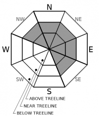
New snow and SW wind will create a new round of wind slabs today. High intensity snowfall combined with ideal wind speeds for slab formation will allow this avalanche problem to form quickly this morning. The vast majority of wind slabs will be found near treeline and above treeline on NW-N-NE-E-SE aspects. Wind slabs will exist to a lesser degree on other aspects and in isolated wind exposed areas below treeline. Avalanches large enough to bury a person (size D2) will be possible today.

Identify and avoid areas of recently wind drifted snow, especially below ridgelines near cornice features and wind pillows as well as in cross loaded gullies. Mentally process and talk within your group about evidence vs uncertainly. If data to support travel in avalanche terrain is sparse and uncertainly lingers, avoid avalanche terrain. Have fun on lower angle slopes.

Avalanche Problem 2: Storm Slab
  • Type ?
  • Aspect/Elevation ?
  • Likelihood ?
    Certain
    Very Likely
    Likely
    Possible
    Unlikely
  • Size ?
    Historic
    Very Large
    Large
    Small

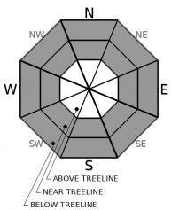
High intensity snowfall this morning will create a fresh round of storm slabs today on all aspects in wind protected areas near treeline and below treeline. Avalanches large enough to bury a person (size D2) will be possible today. Colder air temperatures my slow the rate of stabilization.

As new snow accumulates this morning, adjust route finding both uphill and downhill to avoid exposure to steeper and/or more consequential terrain. This includes slope scale micro features and terrain traps below.

recent observations

* No new reports of avalanches from the past 24 hours.

* Friday's observations made and received from Frog Lake Cliffs (Carson Pass area), Grouse Rock (Ward Canyon area), and Relay Peak (Mount Rose area) indicate that the existing snowpack is in good condition to handle new snow loading.

* The deepest snowpack with good coverage exists along the Sierra Crest above 7,500'. Areas of shallow snowcover with ongoing concerns for hitting rocks, etc remain at lower elevations as well as along the eastern portion of the forecast area at all elevations.

Weather and CURRENT CONDITIONS
weather summary

A strong cold front will move through the forecast area today. A period of high intensity snowfall is expected this morning. The front will move through the area rather quickly with widespread snowfall tapering off fairly abruptly this afternoon. Short periods of isolated snow showers may continue this afternoon due to atmospheric instability. Moderate to strong SW ridgetop winds will continue today. Ridgetop winds are forecast to shift to the NW to N tonight and become light tomorrow. A short lived period of cold and dry conditions are expected through Monday before the next storm system reaches the region.

CONDITIONS ALONG THE SIERRA CREST BETWEEN 8200 FT. AND 9200 FT. IN THE LAST 24 HOURS
6am temperature: 16 to 22 deg. F.
Max. temperature: 26 to 31 deg. F.
Average ridgetop wind direction: WSW
Average ridgetop wind speed: 31 mph
Maximum ridgetop wind gust: 67 mph
New snowfall: Trace to 2 inches
Total snow depth: 27 to 37 inches
Two-Day Mountain Weather Forecast Produced in partnership with the Reno NWS
For 7000 ft. to 8000 ft.
Saturday Saturday Night Sunday
Weather: Cloudy. Snow. Snow levels below 7000 feet. Chance of precipitation is 100%. Mostly cloudy. Scattered snow showers. Snow levels below 7000 feet. Chance of precipitation is 30%. Partly cloudy. Snow levels below 7000 feet. Chance of precipitation is 5%.
Temperatures: 23 to 28. deg. F. 11 to 19. deg. F. 22 to 28. deg. F.
Mid Slope Winds: Southwest 15 to 25 mph with gusts to 40 mph. West to northwest 10 to 15 mph. Gusts up to 25 mph in the evening. Light winds.
Expected snowfall: 70% probability of 8 to 12 inches. 30% probability of 4 to 8 inches. | SWE = up to 0.60 inch. 80% probability up to 1 inch. 20% probability of 1 to 2 inches. | SWE = less than 0.10 inch. No accumulation. | SWE = none.
For 8000 ft. to 9000 ft.
Saturday Saturday Night Sunday
Weather: Cloudy. Snow. Snow levels below 7000 feet. Chance of precipitation is 100%. Mostly cloudy. Scattered snow showers. Snow levels below 7000 feet. Chance of precipitation is 30%. Partly cloudy. Snow levels below 7000 feet. Chance of precipitation is 5%.
Temperatures: 19 to 25. deg. F. 10 to 16. deg. F. 16 to 22. deg. F.
Ridge Top Winds: Southwest 25 to 40 mph shifting to the west 20 to 30 mph in the afternoon. Gusts up to 65 mph. Northwest 15 to 25 mph. Gusts up to 45 mph decreasing to 30 mph after midnight. North 10 to 20 mph with gusts to 35 mph in the morning becoming west around 10 mph.
Expected snowfall: 80% probability of 8 to 14 inches. 20% probability of 5 to 8 inches. | SWE = 0.50-0.75 inch. 70% probability up to 1 inch. 30% probability of 1 to 3 inches. | SWE = less than 0.10 inch. No accumulation. | SWE = none.
Disclaimer

This avalanche advisory is provided through a partnership between the Tahoe National Forest and the Sierra Avalanche Center. This advisory covers the Central Sierra Nevada Mountains between Yuba Pass on the north and Ebbetts Pass on the south. Click here for a map of the forecast area. This advisory applies only to backcountry areas outside established ski area boundaries. This advisory describes general avalanche conditions and local variations always occur. This advisory expires 24 hours after the posted time unless otherwise noted. The information in this advisory is provided by the USDA Forest Service who is solely responsible for its content.

For a recorded version of the Avalanche Advisory call (530) 587-3558 x258