THIS AVALANCHE FORECAST EXPIRED ON December 11, 2018 @ 6:59 am
Avalanche Forecast published on December 10, 2018 @ 6:59 am
Issued by Andy Anderson - Tahoe National Forest - Sierra Avalanche Center

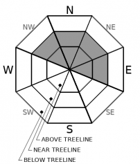
Some wind slabs may exist on top of a buried weak layer in some areas in very wind-exposed near and above treeline terrain. The avalanche danger is MODERATE. Human triggered avalanches may be possible today.

2. Moderate

?

Above Treeline
Heightened avalanche conditions on specific terrain features. Evaluate snow and terrain carefully; identify features of concern.

2. Moderate

?

Near Treeline
Heightened avalanche conditions on specific terrain features. Evaluate snow and terrain carefully; identify features of concern.

1. Low

?

Below Treeline
Generally safe avalanche conditions. Watch for unstable snow on isolated terrain features.
    Heightened avalanche conditions on specific terrain features. Evaluate snow and terrain carefully; identify features of concern.
Avalanche Problem 1: Wind Slab
  • Type ?
  • Aspect/Elevation ?
  • Likelihood ?
    Certain
    Very Likely
    Likely
    Possible
    Unlikely
  • Size ?
    Historic
    Very Large
    Large
    Small

Firm sun crusts on many windward slopes and moderate wind speeds limited wind slab formation to the most wind-exposed NW-N-NE-E aspects in near and above treeline terrain. In some cases, these wind slabs formed on top of weak feathery snow known as surface hoar. Some wind transport and wind-loading could continue today in isolated areas particularly if any new snow accumulates. Most avalanches resulting from these wind slabs should remain small. Small avalanches can have serious consequences especially with all the rocks and obstacles lurking near the snow surface. It is not impossible for a wind slab avalanche to involve enough snow to bury or injure a person (size D2) in some areas. 

Signs that wind slabs may exist on a slope include cornices above a slope, wind drifts/pillows, ripples/wind-created textures on the snow surface, hollow sounding firm snow, and current blowing snow. The buried surface hoar will make any wind slabs that do exist more difficult to manage. Surface hoar can allow remote triggering of avalanches and can allow avalanches to propagate across wider areas and run farther downslope. If there are any doubts or uncertainty about the existence of an unstable wind slab on a slope, assume the slope is unstable and avoid it. Avoiding wind-loaded terrain where problematic wind slabs may linger represents a great way to manage today's potential avalanche problem and to enjoy the cold soft snow that still remains in many more-sheltered, non-wind-exposed areas.

recent observations

* Along the upper elevation ridgelines and in very exposed near treeline areas small fragile wind slabs and new cornices were observed in the area between Castle and Basin Peak yesterday. Ski cuts caused shooting cracks and small wind slab failures on wind-loaded test slopes. No wind slab formation was seen at lower elevations or in less exposed terrain.

* Widespread wind scouring had occurred on the windward aspects on Castle Peak. Firm sun crusts had also formed on the sun-exposed aspects on Castle Peak, Basin Peak, Tamarack Peak, and Andesite Peak. Both of these factors helped limit wind transport.

* Widespread surface hoar existed on shaded sheltered slopes in the Donner Summit and Mt. Rose areas.

* Decent snow coverage exists above 7,000' to 7,500' along the Sierra Crest with the best coverage in the northern and far southern Sierra Crest portions of the forecast area.  Snow coverage declines to the east. Early season conditions exist.

** Vague reports of a skier incident on Tallac yesterday came in this morning, but no details concerning whether or not it was an avalanche incident or a fall exist. If we get information that it was an avalanche incident, we will update the site. 


Weather and CURRENT CONDITIONS
weather summary

Ridgetop winds remained strong during the night and should continue today as a weak storm system impacts the area. Increased cloud cover and continued southwest winds represent the main effects of this system. Some light snow accumulations (up to an inch) may be possible in the mountains especially in areas north of Hwy. 50. Another weak system could move into the area on Tuesday night.

CONDITIONS ALONG THE SIERRA CREST BETWEEN 8200 FT. AND 9200 FT. IN THE LAST 24 HOURS
6am temperature: 26 to 31 deg. F.
Max. temperature: 38 to 45 deg. F.
Average ridgetop wind direction: SW
Average ridgetop wind speed: 25 to 35 mph
Maximum ridgetop wind gust: 52 mph
New snowfall: 0 inches
Total snow depth: 22 to 33 inches
Two-Day Mountain Weather Forecast Produced in partnership with the Reno NWS
For 7000 ft. to 8000 ft.
Monday Monday Night Tuesday
Weather: Mostly cloudy. Snow likely through the day. Snow levels below 7000 feet. Chance of precipitation is 60%. Mostly cloudy then becoming partly cloudy. Chance of snow. Snow levels below 7000 feet. Chance of precipitation is 30%. Partly cloudy. Snow levels below 7000 feet. Chance of precipitation is 5%.
Temperatures: 35 to 40. deg. F. 16 to 22. deg. F. 33 to 38. deg. F.
Mid Slope Winds: Southwest 10 to 15 mph with gusts to 25 mph in the morning becoming light. Light winds. Light winds.
Expected snowfall: 80% probability up to 1 inch. 20% probability of 1 to 3 inches. | SWE = less than 0.10 inch. 30% probability up to 1 inch. 70% probability no accumulation. | SWE = trace amounts. No accumulation. | SWE = none.
For 8000 ft. to 9000 ft.
Monday Monday Night Tuesday
Weather: Mostly cloudy. Chance of snow through the day. Snow levels below 7000 feet. Chance of precipitation is 60%. Mostly cloudy then becoming partly cloudy. Chance of snow. Snow levels below 7000 feet. Chance of precipitation is 30%. Partly cloudy then becoming sunny. Snow levels below 7000 feet. Chance of precipitation is 5%.
Temperatures: 33 to 38. deg. F. 15 to 20. deg. F. 30 to 35. deg. F.
Ridge Top Winds: Southwest 15 to 30 mph with gusts to 60 mph. Southwest 10 to 15 mph shifting to the east after midnight. Gusts up to 30 mph. Northeast 10 to 15 mph with gusts to 30 mph.
Expected snowfall: 80% probability up to 1 inch. 20% probability of 1 to 4 inches. | SWE = less than 0.10 inch. 30% probability up to 1 inch. 70% probability no accumulation. | SWE = trace amounts. No accumulation. | SWE = none.
Disclaimer

This avalanche advisory is provided through a partnership between the Tahoe National Forest and the Sierra Avalanche Center. This advisory covers the Central Sierra Nevada Mountains between Yuba Pass on the north and Ebbetts Pass on the south. Click here for a map of the forecast area. This advisory applies only to backcountry areas outside established ski area boundaries. This advisory describes general avalanche conditions and local variations always occur. This advisory expires 24 hours after the posted time unless otherwise noted. The information in this advisory is provided by the USDA Forest Service who is solely responsible for its content.

For a recorded version of the Avalanche Advisory call (530) 587-3558 x258