THIS AVALANCHE FORECAST EXPIRED ON December 15, 2018 @ 6:45 am
Avalanche Forecast published on December 14, 2018 @ 6:45 am
Issued by Brandon Schwartz - Tahoe National Forest

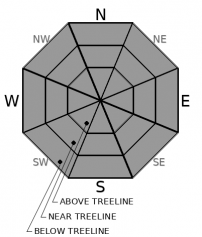
LOW avalanche danger continues for all elevations. Avalanche activity remains unlikely, but keep an eye out for isolated instability in any areas where drifting snow accumulates.

1. Low

?

Above Treeline
Generally safe avalanche conditions. Watch for unstable snow on isolated terrain features.

1. Low

?

Near Treeline
Generally safe avalanche conditions. Watch for unstable snow on isolated terrain features.

1. Low

?

Below Treeline
Generally safe avalanche conditions. Watch for unstable snow on isolated terrain features.
    Generally safe avalanche conditions. Watch for unstable snow on isolated terrain features.
Avalanche Problem 1: Normal Caution
  • Type ?
  • Aspect/Elevation ?
  • Likelihood ?
    Certain
    Very Likely
    Likely
    Possible
    Unlikely
  • Size ?
    Historic
    Very Large
    Large
    Small

S to SW ridgetop winds are going to blow hard today, gusting up to 115 mph. This will certainly scour and transport any snow that remains available for wind transport. The big issue is that previous SW wind scouring and melt-freeze crust formation on windward aspects has left very little snow available for wind transport. In the unlikely event that new areas of unstable snow can form today, characteristics will be that of a wind slab. Avalanche size is expected to be too small to bury a person (size D1).

Move around the mountains today exercising normal caution. Have a travel plan for the day, travel through avalanche terrain one at a time, regroup out of avalanche terrain, and practice effective communication within your group. Keep an eye out for any isolated areas where drifting snow is accumulating and the unlikely encounter with a newly formed, unstable wind slab.

recent observations

* Observations made yesterday on Talking Mountain (Echo Summit area), Silver Peak (Pole Creek area), and Johnson Canyon (Donner Summit area) all matched well with previous observations from around the forecast area and gave no indications of snowpack instability. Thin snowcover and early season conditions exist in many areas.

* The upper layers of the snowpack on NW-N-NE-ENE aspects continue to hold a mix of near surface facets, varying degrees of the Dec 4 buried surface hoar layer, areas of old wind slab, and wind scoured snow surfaces depending on exposure to or protection from SW and NE winds.

* Surface melt-freeze crust has formed in most areas on E-SE-S-SW-W aspects.

* The mid and lower protions of the snowpack on all aspects are well bonded and lack a problematic weak layer.

Weather and CURRENT CONDITIONS
weather summary

A storm system will pass by to the north today. The main effects will be gale force winds, some cloud cover, and some very minimal snowfall. Air temperatures are at or above freezing at many mountain locations this morning. Further warming will occur during the daytime hours. Winds speeds will continue to increase to gale force this morning, peaking this afternoon, continuing through this evening and starting to decrease after midnight tonight. Some light snowfall is forecast for this evening with up to 1 inch of accumulation expected. Snow level is expected around 5,000'-5,500'. A stronger storm system with more significant snowfall is forecast for Sunday night into Monday.

CONDITIONS ALONG THE SIERRA CREST BETWEEN 8200 FT. AND 9200 FT. IN THE LAST 24 HOURS
6am temperature: 32 to 38 deg. F.
Max. temperature: 44 to 52 deg. F.
Average ridgetop wind direction: SW
Average ridgetop wind speed: 23 mph
Maximum ridgetop wind gust: 73 mph
New snowfall: 0 inches
Total snow depth: 25 to 31 inches
Two-Day Mountain Weather Forecast Produced in partnership with the Reno NWS
For 7000 ft. to 8000 ft.
Friday Friday Night Saturday
Weather: Mostly cloudy then becoming partly cloudy. Snow levels below 7000 feet. Chance of precipitation is 0%. Clear then becoming partly cloudy. Isolated snow showers. Snow levels below 7000 feet. Chance of precipitation is 15%. Mostly cloudy. Snow levels below 7000 feet. Chance of precipitation is 0%.
Temperatures: 43 to 48. deg. F. 25 to 30. deg. F. 41 to 46. deg. F.
Mid Slope Winds: Southwest 15 to 25 mph with gusts to 45 mph increasing to south 30 to 40 mph with gusts to 80 mph in the afternoon. Southwest 30 to 40 mph with gusts to 85 mph decreasing to 15 to 20 mph with gusts to 45 mph after midnight. Southwest 10 to 15 mph in the morning becoming light. Gusts up to 30 mph in the morning.
Expected snowfall: No accumulation. | SWE = none. 80% probability up to 1 inch. 20% probability 1 to 2 inches. | SWE = less than 0.10 inch. No accumulation. | SWE = none.
For 8000 ft. to 9000 ft.
Friday Friday Night Saturday
Weather: Mostly cloudy then becoming partly cloudy. Snow levels below 7000 feet. Chance of precipitation is 0%. Clear then becoming partly cloudy. Isolated snow showers in the evening. Snow levels below 7000 feet. Chance of precipitation is 15%. Mostly cloudy. Snow levels below 7000 feet. Chance of precipitation is 0%.
Temperatures: 38 to 43. deg. F. 21 to 26. deg. F. 39 to 44. deg. F.
Ridge Top Winds: South 30 to 45 mph with gusts to 90 mph increasing to 40 to 60 mph with gusts to 115 mph in the afternoon. Southwest 40 to 55 mph with gusts to 110 mph decreasing to 25 to 35 mph with gusts to 70 mph after midnight. Southwest 15 to 25 mph with gusts to 45 mph.
Expected snowfall: No accumulation. | SWE = none. 80% probability up to 1 inch. 20% probability 1 to 2 inches. | SWE = less than 0.10 inch. No accumulation. | SWE = none.
Disclaimer

This avalanche advisory is provided through a partnership between the Tahoe National Forest and the Sierra Avalanche Center. This advisory covers the Central Sierra Nevada Mountains between Yuba Pass on the north and Ebbetts Pass on the south. Click here for a map of the forecast area. This advisory applies only to backcountry areas outside established ski area boundaries. This advisory describes general avalanche conditions and local variations always occur. This advisory expires 24 hours after the posted time unless otherwise noted. The information in this advisory is provided by the USDA Forest Service who is solely responsible for its content.

For a recorded version of the Avalanche Advisory call (530) 587-3558 x258