THIS AVALANCHE FORECAST EXPIRED ON December 16, 2018 @ 6:53 am
Avalanche Forecast published on December 15, 2018 @ 6:53 am
Issued by Brandon Schwartz - Tahoe National Forest

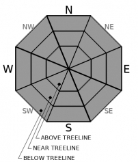
LOW avalanche danger continues for all elevations. Avalanche activity is unlikely, but remain cautious if traveling in areas of firm wind slab.

1. Low

?

Above Treeline
Generally safe avalanche conditions. Watch for unstable snow on isolated terrain features.

1. Low

?

Near Treeline
Generally safe avalanche conditions. Watch for unstable snow on isolated terrain features.

1. Low

?

Below Treeline
Generally safe avalanche conditions. Watch for unstable snow on isolated terrain features.
    Generally safe avalanche conditions. Watch for unstable snow on isolated terrain features.
Avalanche Problem 1: Normal Caution
  • Type ?
  • Aspect/Elevation ?
  • Likelihood ?
    Certain
    Very Likely
    Likely
    Possible
    Unlikely
  • Size ?
    Historic
    Very Large
    Large
    Small

Areas of firm wind slab formed yesterday as well as earlier this week. These slabs are difficult to trigger and avalanche activity is unlikely. Avalanche size is expected to be too small to bury a person (size D1). Move around the mountains today exercising normal caution. Have a travel plan for the day, travel through avalanche terrain one at a time, regroup out of avalanche terrain, and practice effective communication within your group. Keep the odds stacked in your favor in case the unexpected area of unstable snow is encountered.

If you insist on traveling in areas of firm wind slab, this is where the unlikely avalanche event would probably happen. Avoid the firm wind slab and go enjoy the soft near surface facets on out of the way wind protected northerly aspects below treeline.

recent observations

* Observations made and received yesterday from the Carson Pass, Ward Canyon, Deep Creek, and Donner Summit areas all reported isolated areas of blowing snow (and in some cases small rocks) in near treeline and above treeline terrain. Some small, shallow, difficult to trigger wind slabs were observed in areas where wind drifted snow accumulated. Thin snowcover and early season conditions exist in many areas.

* Significantly wind affected snow surfaces exist near treeline and above treeline with a mix of hard ice, wind scoured areas, and firm wind slab.

* Below treeline there is a mix of near surface facets, varying degrees of the Dec 4 buried surface hoar layer, areas of firm wind slab, as well as melt-freeze crust depending on aspect and exposure to sun and previous winds.

* Areas where the upper portion of the snowpack holds near surface facets or the Dec 4 buried surface hoar layer are in poor condition to handle new snow loading. This is mainly on NW-N-NE-ENE aspects.

* The mid and lower portions of the snowpack on all aspects are well bonded and lack a problematic weak layer.

Weather and CURRENT CONDITIONS
weather summary

SW ridgetop winds will remain moderate to strong as yesterday's wind event exits the region. Maximum daytime air temperatures are expected to climb above freezing today for most locations. Continued SW winds are forecast for tomorrow prior to the arrival of the next storm system late Sunday. There is a slight chance of snow showers tomorrow afternoon followed by a period of more significant snowfall tomorrow night.

CONDITIONS ALONG THE SIERRA CREST BETWEEN 8200 FT. AND 9200 FT. IN THE LAST 24 HOURS
6am temperature: 27 to 34 deg. F.
Max. temperature: 35 to 40 deg. F.
Average ridgetop wind direction: SW
Average ridgetop wind speed: 60 mph
Maximum ridgetop wind gust: 117 mph
New snowfall: 0 to trace inches
Total snow depth: 25 to 30 inches
Two-Day Mountain Weather Forecast Produced in partnership with the Reno NWS
For 7000 ft. to 8000 ft.
Saturday Saturday Night Sunday
Weather: Mostly cloudy. Snow levels below 7000 feet. Chance of precipitation is 0%. Mostly cloudy. Snow levels below 7000 feet. Chance of precipitation is 0%. Mostly cloudy. Slight chance of snow showers in the afternoon. Snow levels below 7000 feet. Chance of precipitation is 10%.
Temperatures: 38 to 43. deg. F. 25 to 30. deg. F. 38 to 43. deg. F.
Mid Slope Winds: Southwest 10 to 20 mph with gusts to 35 mph. South 10 to 15 mph with gusts up to 30 mph increasing to south 15 to 20 mph with gusts to 40 mph after midnight. South 15 to 25 mph. Gusts up to 55 mph.
Expected snowfall: No accumulation. | SWE = none. No accumulation. | SWE = none. No accumulation. | SWE = none.
For 8000 ft. to 9000 ft.
Saturday Saturday Night Sunday
Weather: Mostly cloudy. Snow levels below 7000 feet. Chance of precipitation is 0%. Mostly cloudy. Snow levels below 7000 feet. Chance of precipitation is 0%. Mostly cloudy. Snow levels below 7000 feet. Chance of precipitation is 10%.
Temperatures: 33 to 38. deg. F. 23 to 28. deg. F. 33 to 38. deg. F.
Ridge Top Winds: Southwest 25 to 35 mph with gusts to 60 mph. South 25 to 35 mph with gusts to 70 mph. South 35 to 45 mph with gusts to 90 mph.
Expected snowfall: No accumulation. | SWE = none. No accumulation. | SWE = none. No accumulation. | SWE = none.
Disclaimer

This avalanche advisory is provided through a partnership between the Tahoe National Forest and the Sierra Avalanche Center. This advisory covers the Central Sierra Nevada Mountains between Yuba Pass on the north and Ebbetts Pass on the south. Click here for a map of the forecast area. This advisory applies only to backcountry areas outside established ski area boundaries. This advisory describes general avalanche conditions and local variations always occur. This advisory expires 24 hours after the posted time unless otherwise noted. The information in this advisory is provided by the USDA Forest Service who is solely responsible for its content.

For a recorded version of the Avalanche Advisory call (530) 587-3558 x258