THIS AVALANCHE FORECAST EXPIRED ON December 17, 2018 @ 6:50 am
Avalanche Forecast published on December 16, 2018 @ 6:50 am
Issued by Andy Anderson - Tahoe National Forest - Sierra Avalanche Center

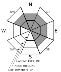
The avalanche danger will remain LOW and avalanche activity will remain unlikely until it starts snowing this evening. Continue to use normal caution when traveling in the backcountry especially in areas where old firm wind slabs may linger. The avalanche danger will increase quickly as snow starts to accumulate tonight and could reach CONSIDERABLE during the night.

3. Considerable

?

Above Treeline
Dangerous avalanche conditions. Careful snowpack evaluation, cautious route-finding and conservative decision-making essential.

3. Considerable

?

Near Treeline
Dangerous avalanche conditions. Careful snowpack evaluation, cautious route-finding and conservative decision-making essential.

2. Moderate

?

Below Treeline
Heightened avalanche conditions on specific terrain features. Evaluate snow and terrain carefully; identify features of concern.
    Dangerous avalanche conditions. Careful snowpack evaluation, cautious route-finding and conservative decision-making essential.
Avalanche Problem 1: Wind Slab
  • Type ?
  • Aspect/Elevation ?
  • Likelihood ?
    Certain
    Very Likely
    Likely
    Possible
    Unlikely
  • Size ?
    Historic
    Very Large
    Large
    Small

Avalanche activity large enough to bury or injure a person will remain unlikely until it starts to snow tonight. Some isolated areas of unstable snow may still linger in wind-exposed terrain around the forecast area in the form of small, firm, and difficult-to-trigger wind slabs. Even though avalanches remain unlikely today, continue to practice responsible backcountry travel by creating good safety margins, stopping to talk to your partners, traveling through avalanche terrain one at a time, regrouping out of avalanche terrain, and constantly reassessing terrain and conditions. 

Choosing to avoid areas with lingering firm wind slabs where unlikely but not impossible instabilities could exist and planning to recreate on the less exposed slopes represents one way to create a great safety margin that would also lead to finding the remaining areas of soft surface snow. 

Once the storm arrives this evening, the avalanche danger will increase quickly as new fragile wind slabs become larger and more widespread during the night.

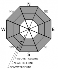
Avalanche Problem 2: Storm Slab
  • Type ?
  • Aspect/Elevation ?
  • Likelihood ?
    Certain
    Very Likely
    Likely
    Possible
    Unlikely
  • Size ?
    Historic
    Very Large
    Large
    Small

As stated above, avalanche activity remains unlikely today. However, once new snow starts to accumulate tonight, storm slab avalanches may become possible.

recent observations

* Observations from Trimmer Peak found some small firm wind slabs resting on top of softer weaker snow in isolated areas. Ski kicks on these isolated drifts did result in some shooting cracks. The largest of these wind slabs still only extended about 40 ft. downslope. Smaller firm wind slabs also existed in a few areas around Ginny Lake and Slab Cliffs, but none of these were more than a few inches deep and did not extend more than a few feet downslope.

* Variable wind-affected snow surface conditions ranging from firm wind scoured surfaces to firm wind packed snow have been reported in wind exposed areas.  In less exposed areas, a mix of variable crusts exists on sun-exposed aspects with some areas of soft unconsolidated snow (near surface facets) still lingering on sheltered northerly aspects.

* In many areas on NW-N-NE-ENE aspects, weak snow exists on or near the top of the snowpack and new loading could result in instability. 

* Observations and snowpit data from Castle Peak, Johnson Canyon, and the Slab Cliffs area yesterday all indicated that the lower snowpack consists of well-bonded snow.

Weather and CURRENT CONDITIONS
weather summary

Clouds and winds should increase today ahead of a storm system projected to move into the region this evening. Ridgetop winds could gust into the 90 mph range by this afternoon. The forecast calls for the winds to continue into the night and for snowfall to start this evening. 3 to 10 inches of snow could accumulate during the night above 7000 ft with a chance for up to 15 inches along the Sierra Crest. 2 to 4 inches of new snow is expected at lake level. Snow levels should start between 6500 and 7000 ft and decrease during and after the storm. Snow and wind should start to decrease by tomorrow with partly cloudy skies, scattered snow showers, and less windy conditions expected by tomorrow afternoon.

CONDITIONS ALONG THE SIERRA CREST BETWEEN 8200 FT. AND 9200 FT. IN THE LAST 24 HOURS
6am temperature: 29 to 35 deg. F.
Max. temperature: 30 to 35 deg. F.
Average ridgetop wind direction: Southwest
Average ridgetop wind speed: 45 to 55 mph
Maximum ridgetop wind gust: 84 mph
New snowfall: 0 inches
Total snow depth: 25 to 30 inches
Two-Day Mountain Weather Forecast Produced in partnership with the Reno NWS
For 7000 ft. to 8000 ft.
Sunday Sunday Night Monday
Weather: Mostly cloudy. Snow levels below 7000 feet increasing to 7000 feet in the afternoon. Chance of precipitation is 5%. Cloudy. Snow. Snow levels below 7000 feet. Chance of precipitation is 100%. Mostly cloudy then becoming partly cloudy. Chance of snow showers in the morning. Snow levels below 7000 feet. Chance of precipitation is 35%.
Temperatures: 38 to 44 deg. F. 25 to 30 deg. F. 30 to 34 deg. F.
Mid Slope Winds: South 15 to 20 mph increasing to 15 to 30 mph in the afternoon. Gusts up to 50 mph. South 15 to 30 mph with gusts to 50 mph. Southwest 10 to 20 mph with gusts to 40 mph decreasing to southwest around 10 mph in the afternoon.
Expected snowfall: No accumulation. | SWE = none. 80% probability of 3 to 7 inches. 20% probability of 7 to 12 inches. | SWE = 0.35-0.55 inch. 40% probability of 1 to 2 inches. 60% probability no accumulation. | SWE = up to 0.15 inch.
For 8000 ft. to 9000 ft.
Sunday Sunday Night Monday
Weather: Mostly cloudy. Snow levels below 7000 feet increasing to 7000 feet in the afternoon. Chance of precipitation is 5%. Cloudy. Snow. Snow levels below 7000 feet. Chance of precipitation is 100%. Mostly cloudy then becoming partly cloudy. Chance of snow showers in the morning. Snow levels below 7000 feet. Chance of precipitation is 40%.
Temperatures: 33 to 38 deg. F. 20 to 25 deg. F. 27 to 31 deg. F.
Ridge Top Winds: South 30 to 45 mph increasing to 35 to 55 mph in the afternoon. Gusts up to 95 mph. South 40 to 55 mph decreasing to 30 to 50 mph after midnight. Gusts up to 110 mph. Southwest 25 to 35 mph with gusts to 85 mph decreasing to 15 to 25 mph with gusts to 50 mph in the afternoon.
Expected snowfall: No accumulation. | SWE = none. 70% probability of 5 to 10 inches. 30% probability of 10 to 14 inches. | SWE = up to 0.70 inch. 40% probability of 1 to 4 inches. 60% probability no accumulation. | SWE = up to 0.15 inch.
Disclaimer

This avalanche advisory is provided through a partnership between the Tahoe National Forest and the Sierra Avalanche Center. This advisory covers the Central Sierra Nevada Mountains between Yuba Pass on the north and Ebbetts Pass on the south. Click here for a map of the forecast area. This advisory applies only to backcountry areas outside established ski area boundaries. This advisory describes general avalanche conditions and local variations always occur. This advisory expires 24 hours after the posted time unless otherwise noted. The information in this advisory is provided by the USDA Forest Service who is solely responsible for its content.

For a recorded version of the Avalanche Advisory call (530) 587-3558 x258