THIS AVALANCHE FORECAST EXPIRED ON December 3, 2018 @ 6:48 am
Avalanche Forecast published on December 2, 2018 @ 6:48 am
Issued by Andy Anderson - Tahoe National Forest - Sierra Avalanche Center

MODERATE avalanche danger exists at all elevations today due to lingering wind slabs and possibly some remaining storm slabs. Human triggered avalanches will remain possible today. If any doubts exist about the stability of a slope, avoid it and move on to something lower angle with less uncertainty.

2. Moderate

?

Above Treeline
Heightened avalanche conditions on specific terrain features. Evaluate snow and terrain carefully; identify features of concern.

2. Moderate

?

Near Treeline
Heightened avalanche conditions on specific terrain features. Evaluate snow and terrain carefully; identify features of concern.

2. Moderate

?

Below Treeline
Heightened avalanche conditions on specific terrain features. Evaluate snow and terrain carefully; identify features of concern.
    Heightened avalanche conditions on specific terrain features. Evaluate snow and terrain carefully; identify features of concern.
Avalanche Problem 1: Wind Slab
  • Type ?
  • Aspect/Elevation ?
  • Likelihood ?
    Certain
    Very Likely
    Likely
    Possible
    Unlikely
  • Size ?
    Historic
    Very Large
    Large
    Small

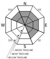
Human triggered wind slab avalanches will remain possible today. Unstable wind slabs could still linger on wind-loaded N-NE-E aspects and cross-loaded NW and SE aspects in near and above treeline terrain. Avalanches resulting from these wind slabs could involve enough snow to bury a person (size D2). Smaller isolated wind slabs in below treeline terrain may still remain possible as well. 

Use clues like cornices above slopes, wind pillows/drifts, ripples on the snow surface, and other signs of wind-loading to identify and then avoid places where wind slabs may exist. Some of these slabs could still be triggered from a distance. Plenty of great snow and recreation opportunities exist on lower angle more sheltered slopes.

Avalanche Problem 2: Storm Slab
  • Type ?
  • Aspect/Elevation ?
  • Likelihood ?
    Certain
    Very Likely
    Likely
    Possible
    Unlikely
  • Size ?
    Historic
    Very Large
    Large
    Small

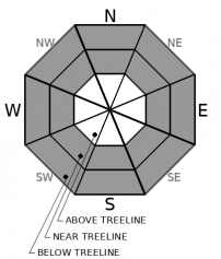
Some unstable storm slabs may still lurk in near and below treeline terrain especially in areas where a thin weak layer of surface hoar may exist below the new snow. A high degree of uncertainty exists as to where these storm slabs may linger and whether or not they remain unstable. If any storm slab avalanches occur, most of them would remain small, but some could still involve enough snow to bury or injure a person especially in areas around terrain traps

Recent avalanches, shooting cracks or collapses, or unstable snowpit tests can all help identify where unstable storm slabs may still exist. Actively look for signs of instability and avoid areas with potential problems. If in doubt assume a slope could remain unstable and avoid it. Due to the high degree uncertainty associated with this problem more conservative decision making would be a prudent choice for today.

recent observations

* Observations on Andesite Peak showed widespread natural wind slab avalanches yesterday as well as a skier triggered wind slab that was triggered remotely. Another skier triggered wind slab avalanche occurred on Rubicon Peak. The crowns for these avalanches ranged from 8 to 12 inches in depth. For more information click on the observations below.

* Numerous signs of instability including test slope failures, shooting cracks, and unstable snowpit test results were reported in the Castle Peak, Andesite Peak, Tamarack Peak, and Rubicon Peak areas in wind-loaded and non-wind-loaded terrain at all elevations.

* Widespread wind-loading occurred throughout the day across the forecast area along with continued snowfall. 

* Snow coverage has improved greatly in most places, but there are still many obstacles on or near the snow surface in some areas. 

Weather and CURRENT CONDITIONS
weather summary

Calmer quieter weather should prevail over the forecast area until Tuesday. The forecast calls for some lingering cloud cover today and tomorrow with some periods of clear skies in the next 36 hours. Temperatures should remain below normal with lows in the single digits and teens and highs in the low 20's above 7000 ft. The winds started to calm down last night and shift towards the northwest. The forecast indicates that they should remain light to moderate at all elevations through tomorrow.

CONDITIONS ALONG THE SIERRA CREST BETWEEN 8200 FT. AND 9200 FT. IN THE LAST 24 HOURS
6am temperature: 13 to 21 deg. F.
Max. temperature: 21 to 25 deg. F.
Average ridgetop wind direction: Southwest shifting to Northwest
Average ridgetop wind speed: Until 8 pm last night: 45 to 55 mph | After 8 pm: 10 to 20 mph
Maximum ridgetop wind gust: 105 mph
New snowfall: 4 to 9 inches
Total snow depth: 32 to 44 inches
Two-Day Mountain Weather Forecast Produced in partnership with the Reno NWS
For 7000 ft. to 8000 ft.
Sunday Sunday Night Monday
Weather: Partly cloudy. Snow levels below 7000 feet. Chance of precipitation is 5%. Partly cloudy then becoming clear. Snow levels below 7000 feet. Chance of precipitation is 0%. Partly cloudy. Snow levels below 7000 feet. Chance of precipitation is 0%.
Temperatures: 22 to 28 deg. F. 8 to 18 deg. F. 28 to 33 deg. F.
Mid Slope Winds: Light winds. Light winds. Light winds.
Expected snowfall: No accumulation. | SWE = none. No accumulation. | SWE = none. No accumulation. | SWE = none.
For 8000 ft. to 9000 ft.
Sunday Sunday Night Monday
Weather: Partly cloudy. Snow levels below 7000 feet. Chance of precipitation is 5%. Partly cloudy then becoming clear. Snow levels below 7000 feet. Chance of precipitation is 0%. Partly cloudy. Snow levels below 7000 feet. Chance of precipitation is 0%.
Temperatures: 16 to 22. deg. F. 7 to 15. deg. F. 24 to 29. deg. F.
Ridge Top Winds: West 10 to 15 mph with gusts to 25 mph. Light winds becoming east to southeast 10 to 20 mph after midnight. Gusts up to 30 mph. Southeast 10 to 15 mph with gusts to 30 mph.
Expected snowfall: No accumulation. | SWE = none. No accumulation. | SWE = none. No accumulation. | SWE = none.
Disclaimer

This avalanche advisory is provided through a partnership between the Tahoe National Forest and the Sierra Avalanche Center. This advisory covers the Central Sierra Nevada Mountains between Yuba Pass on the north and Ebbetts Pass on the south. Click here for a map of the forecast area. This advisory applies only to backcountry areas outside established ski area boundaries. This advisory describes general avalanche conditions and local variations always occur. This advisory expires 24 hours after the posted time unless otherwise noted. The information in this advisory is provided by the USDA Forest Service who is solely responsible for its content.

For a recorded version of the Avalanche Advisory call (530) 587-3558 x258