THIS AVALANCHE FORECAST EXPIRED ON December 22, 2018 @ 6:58 am
Avalanche Forecast published on December 21, 2018 @ 6:58 am
Issued by Brandon Schwartz - Tahoe National Forest

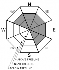
MODERATE avalanche danger continues in near treeline and above treeline terrain due to old and new wind slabs. LOW avalanche danger exists in wind protected areas below treeline.

2. Moderate

?

Above Treeline
Heightened avalanche conditions on specific terrain features. Evaluate snow and terrain carefully; identify features of concern.

2. Moderate

?

Near Treeline
Heightened avalanche conditions on specific terrain features. Evaluate snow and terrain carefully; identify features of concern.

1. Low

?

Below Treeline
Generally safe avalanche conditions. Watch for unstable snow on isolated terrain features.
    Heightened avalanche conditions on specific terrain features. Evaluate snow and terrain carefully; identify features of concern.
Avalanche Problem 1: Wind Slab
  • Type ?
  • Aspect/Elevation ?
  • Likelihood ?
    Certain
    Very Likely
    Likely
    Possible
    Unlikely
  • Size ?
    Historic
    Very Large
    Large
    Small

New wind slabs on top of old wind slabs on top of weak, sometimes faceted older snow. Not a great setup. New snow with wind last night and various periods of blowing snow this past week created this stack of wind slabs. The most problematic areas are near and above treeline terrain on NW-N-NE-E-SE aspects. Avalanche size up to D2 (large enough to bury or injure a person) is possible.

Slope scale stability assessments could be a little tricky today with the stack of wind slabs. Simple informal new snow observations may not tell the whole story. There will be acceptable options and poor options for travel in avalanche terrain today.  Make sure your route plan includes options. If you want to try to avoid this avalanche problem and find the highest snow quality, go for wind protected areas below treeline.

recent observations

* Wind slabs that formed during various wind events this past week, mainly last Friday and Tuesday, sit on top of weak, sometimes faceted snow.

* Unconsolidated snow existed on the surface in shaded, wind protected areas prior to last night's snowfall.

* Reported wind slab avalanche activity this past week tallies at 5 human triggered and 9 natural avalanches, most of which occurred Tuesday and Wednesday.

Weather and CURRENT CONDITIONS
weather summary

The main band of precipitation is tapering off this morning and is expected to exit the area around daybreak. Snow levels were around 6,500' for the most part last night. Ridgetop winds were out of the SW and at moderate to strong in speed for the past 24 hours. The forecast gale force winds have yet to materialize, but may do so later this morning. A break in the weather will occur tonight and tomorrow before the next storm system begins to impact the region Sunday afternoon into Monday.

CONDITIONS ALONG THE SIERRA CREST BETWEEN 8200 FT. AND 9200 FT. IN THE LAST 24 HOURS
6am temperature: 28 to 32 deg. F.
Max. temperature: 40 to 47 deg. F.
Average ridgetop wind direction: SW
Average ridgetop wind speed: 41 mph
Maximum ridgetop wind gust: 65 mph
New snowfall: 2 to 4 inches
Total snow depth: 28 to 33 inches
Two-Day Mountain Weather Forecast Produced in partnership with the Reno NWS
For 7000 ft. to 8000 ft.
Friday Friday Night Saturday
Weather: Mostly cloudy. Chance of showers. Snow levels 7000 feet. Chance of precipitation is 35%. Partly cloudy. Snow levels below 7000 feet. Chance of precipitation is 0%. Partly cloudy then becoming mostly cloudy. Snow levels below 7000 feet. Chance of precipitation is 5%.
Temperatures: 38 to 43. deg. F. 19 to 24. deg. F. 38 to 43. deg. F.
Mid Slope Winds: Southwest 15 to 20 mph. Gusts up to 45 mph decreasing to 30 mph in the afternoon. Light winds. Light winds.
Expected snowfall: Up to 2 inches. | SWE = less than 0.10 inch. No accumulation. | SWE = none. No accumulation. | SWE = none.
For 8000 ft. to 9000 ft.
Friday Friday Night Saturday
Weather: Mostly cloudy. Chance of snow showers. Snow levels 7000 feet. Chance of precipitation is 35%. Partly cloudy. Snow levels below 7000 feet. Chance of precipitation is 0%. Partly cloudy then becoming mostly cloudy. Snow levels below 7000 feet. Chance of precipitation is 5%.
Temperatures: 36 to 41. deg. F. 21 to 26. deg. F. 36 to 41. deg. F.
Ridge Top Winds: Southwest 30 to 40 mph with gusts to 85 mph decreasing to 15 to 30 mph with gusts to 55 mph in the afternoon. West 15 to 20 mph with gusts to 35 mph. South 10 to 15 mph with gusts to 35 mph.
Expected snowfall: Up to 2 inches. | SWE = less than 0.10 inch. No accumulation. | SWE = none. No accumulation. | SWE = none.
Disclaimer

This avalanche forecast is provided through a partnership between the Tahoe National Forest and the Sierra Avalanche Center. This forecast covers the Central Sierra Nevada Mountains between Yuba Pass on the north and Ebbetts Pass on the south. Click here for a map of the forecast area. This forecast applies only to backcountry areas outside established ski area boundaries. This forecast describes general avalanche conditions and local variations always occur. This forecast expires 24 hours after the posted time unless otherwise noted. The information in this forecast is provided by the USDA Forest Service who is solely responsible for its content.

For a recorded version of the avalanche forecast call (530) 587-3558 x258