THIS AVALANCHE FORECAST EXPIRED ON December 23, 2018 @ 6:54 am
Avalanche Forecast published on December 22, 2018 @ 6:54 am
Issued by Brandon Schwartz - Tahoe National Forest

LOW avalanche danger exists today for all elevations. A wind slab avalanche problem lingers near and above treeline. Human triggered avalanches are not impossible today.

1. Low

?

Above Treeline
Generally safe avalanche conditions. Watch for unstable snow on isolated terrain features.

1. Low

?

Near Treeline
Generally safe avalanche conditions. Watch for unstable snow on isolated terrain features.

1. Low

?

Below Treeline
Generally safe avalanche conditions. Watch for unstable snow on isolated terrain features.
    Generally safe avalanche conditions. Watch for unstable snow on isolated terrain features.
Avalanche Problem 1: Wind Slab
  • Type ?
  • Aspect/Elevation ?
  • Likelihood ?
    Certain
    Very Likely
    Likely
    Possible
    Unlikely
  • Size ?
    Historic
    Very Large
    Large
    Small

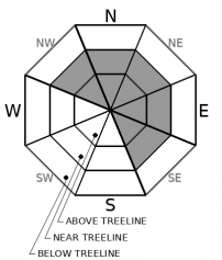
Wind slabs remain a problem near and above treeline on NW-N-NE-E-SE aspects. Wind slabs are expected to be more difficult to trigger today than yesterday. Yesterday's new wind slabs were deposited on top of older wind slabs. In some cases, weak faceted snow exists below a stack of wind slabs. Surface crust formation from yesterdays rain on snow event will have added strength to the upper snowpack in some areas. Any avalanches that occur today are expected to be small (D1), with the isolated possibility of an avalanche large enough to bury a person (D2).

Evidence of instability is expected to be minimal today. Don't allow this to lull your group into complacency or sloppy travel techniques in avalanche terrain. Stack the odds in your favor against the event that the unlikely avalanche is triggered by your party.

recent observations

* Easy to trigger wind slab avalanches up to 6 inches deep were observed yesterday on test slopes near the summit of Powderhouse Peak (Luther Pass area).

* Newly formed but unreactive wind slabs up to 6 inches deep were observed yesterday on Andesite Peak (Donner Summit area).

* Snow levels rose to around 8,700' along the Sierra Crest yesterday with very light rain falling on new snow. A crusted snow surface is expected to have formed last night in many areas.

* The bottom layers of the snowpack remain well bonded, lacking a problematic weak layer.

Weather and CURRENT CONDITIONS
weather summary

A break in the weather will occur today before the next storm system begins to affect the forecast area tomorrow afternoon. Ridgetop winds shifted to the NE last night but have remained light in speed. Ridgetop winds are expected to shift back to the SW this afternoon. Check with Reno NWS for info on the upcoming storm.

CONDITIONS ALONG THE SIERRA CREST BETWEEN 8200 FT. AND 9200 FT. IN THE LAST 24 HOURS
6am temperature: 23 to 33 deg. F.
Max. temperature: 31 to 37 deg. F.
Average ridgetop wind direction: SW
Average ridgetop wind speed: 29 mph
Maximum ridgetop wind gust: 62 mph
New snowfall: Up to 1 inches
Total snow depth: 27 to 34 inches
Two-Day Mountain Weather Forecast Produced in partnership with the Reno NWS
For 7000 ft. to 8000 ft.
Saturday Saturday Night Sunday
Weather: Partly cloudy then becoming mostly cloudy. Snow levels below 7000 feet. Chance of precipitation is 5%. Mostly cloudy. Snow levels below 7000 feet. Chance of precipitation is 10%. Partly cloudy then becoming mostly cloudy. Slight chance of snow in the afternoon. Snow levels below 7000 feet. Chance of precipitation is 15%.
Temperatures: 40 to 45. deg. F. 23 to 28. deg. F. 38 to 43. deg. F.
Mid Slope Winds: Light winds. Southwest 10 to 15 mph with gusts to 30 mph. Light winds. Gusts up to 25 mph in the morning.
Expected snowfall: No accumulation. | SWE = none. No accumulation. | SWE = none. No accumulation. | SWE = trace amounts.
For 8000 ft. to 9000 ft.
Saturday Saturday Night Sunday
Weather: Partly cloudy then becoming mostly cloudy. Snow levels below 7000 feet. Chance of precipitation is 5%. Mostly cloudy. Snow levels below 7000 feet. Chance of precipitation is 10%. Partly cloudy then becoming mostly cloudy. Slight chance of snow in the afternoon. Snow levels below 7000 feet. Chance of precipitation is 15%.
Temperatures: 37 to 43. deg. F. 22 to 27. deg. F. 35 to 40. deg. F.
Ridge Top Winds: East 10 to 15 mph shifting to the southwest with gusts to 30 mph in the afternoon. Southwest 15 to 25 mph with gusts to 45 mph. Southwest 15 to 25 mph with gusts to 40 mph.
Expected snowfall: No accumulation. | SWE = none. No accumulation. | SWE = none. No accumulation. | SWE = trace amounts.
Disclaimer

This avalanche forecast is provided through a partnership between the Tahoe National Forest and the Sierra Avalanche Center. This forecast covers the Central Sierra Nevada Mountains between Yuba Pass on the north and Ebbetts Pass on the south. Click here for a map of the forecast area. This forecast applies only to backcountry areas outside established ski area boundaries. This forecast describes general avalanche conditions and local variations always occur. This forecast expires 24 hours after the posted time unless otherwise noted. The information in this forecast is provided by the USDA Forest Service who is solely responsible for its content.

For a recorded version of the avalanche forecast call (530) 587-3558 x258