THIS AVALANCHE FORECAST EXPIRED ON December 25, 2018 @ 7:00 am
Avalanche Forecast published on December 24, 2018 @ 7:00 am
Issued by Andy Anderson - Tahoe National Forest - Sierra Avalanche Center

The avalanche danger will rise to MODERATE during the day as new wind slabs form in near and above treeline terrain. Human-triggered avalanches will become possible. Overnight the avalanche danger will continue rising to CONSIDERABLE as wind slabs become larger and more widespread and storm slabs may become possible in below treeline terrain. 

3. Considerable

?

Above Treeline
Dangerous avalanche conditions. Careful snowpack evaluation, cautious route-finding and conservative decision-making essential.

3. Considerable

?

Near Treeline
Dangerous avalanche conditions. Careful snowpack evaluation, cautious route-finding and conservative decision-making essential.

2. Moderate

?

Below Treeline
Heightened avalanche conditions on specific terrain features. Evaluate snow and terrain carefully; identify features of concern.
    Dangerous avalanche conditions. Careful snowpack evaluation, cautious route-finding and conservative decision-making essential.
Avalanche Problem 1: Wind Slab
  • Type ?
  • Aspect/Elevation ?
  • Likelihood ?
    Certain
    Very Likely
    Likely
    Possible
    Unlikely
  • Size ?
    Historic
    Very Large
    Large
    Small

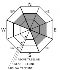
New snow and wind will form wind slabs on wind-loaded N-NE-E aspects and on cross-loaded NW and SE aspects. They should start small this morning but could grow large enough to bury or injure a person during the day. Human-triggered wind slab avalanches will become possible today. As the storm intensifies tonight, wind slabs will become larger, more widespread, and more fragile. Natural wind slabs avalanches will become possible tonight.

Watch for signs of wind-loading to identify where wind slabs may be growing today. Those areas will likely hold variable and challenging snow conditions with the possibility of finding an unstable wind slab. On the other hand, if softer more consistent snow with fewer chances of instability sounds fun, upper elevation areas sheltered from the wind could be a good bet.

Avalanche Problem 2: Storm Slab
  • Type ?
  • Aspect/Elevation ?
  • Likelihood ?
    Certain
    Very Likely
    Likely
    Possible
    Unlikely
  • Size ?
    Historic
    Very Large
    Large
    Small

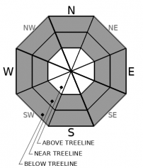
Storm slab avalanches should remain unlikely for most of the day due to the expected snowfall amounts and snowfall rates. During the night, increased snowfall rates and accumulation could allow storm slabs to become larger and more widespread.

recent observations

* Observations on the Sierra Crest yesterday found about an inch of new snow resting on top of a variable rain crust. At the upper elevations (above 8700 ft), this crust becomes more breakable and thin. The crust did not exist above 8800 ft. in the Mt. Rose backcountry.

* Some potential weak layers still exist near and just below the snow surface.

Weather and CURRENT CONDITIONS
weather summary

Snow showers yesterday should give way to stormier conditions today and tonight. Southwest winds and cloud cover have increased and snowfall should become more widespread today. By this evening snow levels should start to fall below 7000 ft and the storm should intensify with snowfall rates approaching 2 inches per hour for periods during the night. The forecast calls for the storm to wind down tomorrow and for the winds to shift to the north and east after the storm ends.

CONDITIONS ALONG THE SIERRA CREST BETWEEN 8200 FT. AND 9200 FT. IN THE LAST 24 HOURS
6am temperature: 29 to 31 deg. F.
Max. temperature: 29 to 31 deg. F.
Average ridgetop wind direction: Southwest
Average ridgetop wind speed: 30 mph
Maximum ridgetop wind gust: 51 mph
New snowfall: up to 2 inches
Total snow depth: 27 to 34 inches
Two-Day Mountain Weather Forecast Produced in partnership with the Reno NWS
For 7000 ft. to 8000 ft.
Monday Monday Night Tuesday
Weather: Cloudy. Chance of snow and rain. Snow levels ~7000 ft. Chance of precipitation is 90 %. Cloudy. Snow and rain in the evening, then widespread snow showers after midnight. Snow levels dropping below 7000 ft. Chance of precipitation is 95%. Mostly cloudy then becoming partly cloudy. Chance of snow showers. Snow levels below 7000 ft. Chance of precipitation is 40%.
Temperatures: 36 to 41 deg. F. 19 to 25 deg. F. 28 to 33 deg. F.
Mid Slope Winds: Southwest 15 to 25 mph. Gusts up to 35 mph increasing to 50 mph in the afternoon. Southwest 15 to 30 mph with gusts to 60 mph shifting to the west 15 to 20 mph with gusts to 40 mph after midnight. North 10 to 15 mph with gusts to 35 mph.
Expected snowfall: 80% probability up to 4 inches. 20% probability of 4 to 6 inches. | SWE = up to .3 inches 80% probability of 5 to 11 inches. 20% probability of 9 to 14 inches. | SWE = .4 to .65 inches Up to 1 inch. | SWE = less than .1 inches.
For 8000 ft. to 9000 ft.
Monday Monday Night Tuesday
Weather: Cloudy. Chance of snow in the morning. Snow becoming widespread by the afternoon. Snow levels ~7000 ft. Chance of precipitation is 90 %. Cloudy. Snow and rain in the evening, then widespread snow showers after midnight. Snow levels dropping below 7000 ft. Chance of precipitation is 95%. Mostly cloudy then becoming partly cloudy. Chance of snow showers. Snow levels below 7000 ft. Chance of precipitation is 40%.
Temperatures: 33 to 38 deg. F. 17 to 22 deg. F. 25 to 30 deg. F.
Ridge Top Winds: Southwest 15 to 30 mph with gusts to 50 mph increasing to 25 to 35 mph with gusts to 70 mph in the afternoon. Southwest 30 to 45 mph with gusts to 80 mph becoming west 15 to 30 mph with gusts to 55 mph after midnight. North 15 to 30 mph with gusts to 50 mph.
Expected snowfall: 80% probability of 1 to 5 inches. 20% probability of 4 to 6 inches. | SWE = up to .3 inches 80% probability of 6 to 12 inches. 20% probability of 12 to 18 inches. | SWE = .5 to .7 inches Up to 1 inch. | SWE = less than .1 inches.
Disclaimer

This avalanche forecast is provided through a partnership between the Tahoe National Forest and the Sierra Avalanche Center. This forecast covers the Central Sierra Nevada Mountains between Yuba Pass on the north and Ebbetts Pass on the south. Click here for a map of the forecast area. This forecast applies only to backcountry areas outside established ski area boundaries. This forecast describes general avalanche conditions and local variations always occur. This forecast expires 24 hours after the posted time unless otherwise noted. The information in this forecast is provided by the USDA Forest Service who is solely responsible for its content.

For a recorded version of the avalanche forecast call (530) 587-3558 x258