THIS AVALANCHE FORECAST EXPIRED ON December 26, 2018 @ 6:59 am
Avalanche Forecast published on December 25, 2018 @ 6:59 am
Issued by Andy Anderson - Tahoe National Forest - Sierra Avalanche Center

Human-triggered avalanches will be likely today in near and above treeline terrain due to a wind slab avalanche problem. The avalanche danger is CONSIDERABLE. Some loose dry avalanches may also be possible in more sheltered terrain. 

3. Considerable

?

Above Treeline
Dangerous avalanche conditions. Careful snowpack evaluation, cautious route-finding and conservative decision-making essential.

3. Considerable

?

Near Treeline
Dangerous avalanche conditions. Careful snowpack evaluation, cautious route-finding and conservative decision-making essential.

2. Moderate

?

Below Treeline
Heightened avalanche conditions on specific terrain features. Evaluate snow and terrain carefully; identify features of concern.
    Dangerous avalanche conditions. Careful snowpack evaluation, cautious route-finding and conservative decision-making essential.
Avalanche Problem 1: Wind Slab
  • Type ?
  • Aspect/Elevation ?
  • Likelihood ?
    Certain
    Very Likely
    Likely
    Possible
    Unlikely
  • Size ?
    Historic
    Very Large
    Large
    Small

New wind slabs have formed on top of old wind slabs that rest on top of old weak surface snow. The largest wind slabs should lurk on NW-N-NE-E-SE aspects loaded by the SW winds in near and above treeline terrain. Smaller wind slabs are possible on NE wind-loaded W-SW-S aspects. In some cases, wind slabs may have crept into wind-exposed areas below treeline as well. While the best period for natural wind slab avalanches should have occurred during the night, human-triggered wind slab avalanches large enough to bury or injure a person will remain likely today. 

Identifying wind-loaded slopes and traveling safely in more exposed terrain may be more difficult today. Clues like cornices above a slope, blowing snow, and wind created surface textures can help, but if you can't tell for sure, assume unstable wind slabs could exist on the slope. Slopes sheltered from the wind could hold consistent soft snow with fewer chances of instability.

Avalanche Problem 2: Loose Dry
  • Type ?
  • Aspect/Elevation ?
  • Likelihood ?
    Certain
    Very Likely
    Likely
    Possible
    Unlikely
  • Size ?
    Historic
    Very Large
    Large
    Small

Cooling temperatures during the storm combined with moderate new snow accumulations should make loose dry sluffs on steep slopes more likely than storm slabs today. They should remain relatively small and only occur in the new snow. While storm slab activity should be unlikely in most areas, storm slabs are not impossible on some isolated terrain features in areas that received the most new snow.  

recent observations

* New wind slabs had formed in the Mt. Rose backcountry by noon yesterday and old wind slabs had become more sensitive. Ski kicks triggered shooting cracks as the stack of new and old wind slabs failed on old weak snow (near surface facets). 

* Observers reported new wind slabs forming on Red Lake Peak by noon yesterday as well. 

* Rain transitioning to snow by mid to late morning was observed at Carson Pass above 7500 ft, on Donner Summit above 7000 ft, and in the Mt. Rose backcountry above 7500 ft. Snow levels fell during the day.

Weather and CURRENT CONDITIONS
weather summary

Yesterday's precipitation started as rain in many places below 7500-8000 ft. Snow levels dropped to between 7000 and 7500 ft by the afternoon and continued to fall overnight allowing 6 to 8 inches of new snow to accumulate over the last 24 hours in most areas. More snow may have accumulated above 8500 ft. The Mt. Rose Snotel sensor showed about 13 inches of new snow. Southwest winds remained strong until about 2 am when the winds shifted to the northeast and decreased. Light snow showers and northeast winds should continue today albeit with little additional accumulation. Expect cool and drier weather tomorrow.

CONDITIONS ALONG THE SIERRA CREST BETWEEN 8200 FT. AND 9200 FT. IN THE LAST 24 HOURS
6am temperature: 18 to 21 deg. F.
Max. temperature: 30 to 34 deg. F.
Average ridgetop wind direction: SW shifting to NE after 2am
Average ridgetop wind speed: SW: 40 to 50 mph | NE: 15 to 25 mph
Maximum ridgetop wind gust: 114 mph
New snowfall: 6 to 8 inches
Total snow depth: 30 to 45 inches
Two-Day Mountain Weather Forecast Produced in partnership with the Reno NWS
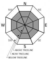
For 7000 ft. to 8000 ft.
Tuesday Tuesday Night Wednesday
Weather: Mostly cloudy. Scattered snow showers. Snow levels below 7000 feet. Chance of precipitation is 50%. Partly cloudy. Snow levels below 7000 feet. Chance of precipitation is 10%. Partly cloudy. Snow levels below 7000 feet. Chance of precipitation is 5%.
Temperatures: 28 to 33. deg. F. 12 to 22. deg. F. 35 to 40. deg. F.
Mid Slope Winds: North 10 to 15 mph with gusts to 35 mph. Northeast 10 to 15 mph with gusts to 30 mph. Light winds.
Expected snowfall: Up to 1 inch. | SWE = less than 0.10 inch. No accumulation. | SWE = none. No accumulation. | SWE = none.
For 8000 ft. to 9000 ft.
Tuesday Tuesday Night Wednesday
Weather: Mostly cloudy. Scattered snow showers. Snow levels below 7000 feet. Chance of precipitation is 45%. Partly cloudy. Snow levels below 7000 feet. Chance of precipitation is 10%. Partly cloudy. Snow levels below 7000 feet. Chance of precipitation is 5%.
Temperatures: 25 to 30. deg. F. 14 to 20. deg. F. 32 to 37. deg. F.
Ridge Top Winds: North 15 to 25 mph with gusts to 45 mph. Northeast 15 to 30 mph with gusts to 55 mph. North 15 to 25 mph. Gusts up to 50 mph decreasing to 40 mph in the afternoon.
Expected snowfall: Up to 1 inch. | SWE = less than 0.10 inch. No accumulation. | SWE = none. No accumulation. | SWE = none.
Disclaimer

This avalanche forecast is provided through a partnership between the Tahoe National Forest and the Sierra Avalanche Center. This forecast covers the Central Sierra Nevada Mountains between Yuba Pass on the north and Ebbetts Pass on the south. Click here for a map of the forecast area. This forecast applies only to backcountry areas outside established ski area boundaries. This forecast describes general avalanche conditions and local variations always occur. This forecast expires 24 hours after the posted time unless otherwise noted. The information in this forecast is provided by the USDA Forest Service who is solely responsible for its content.

For a recorded version of the avalanche forecast call (530) 587-3558 x258