THIS AVALANCHE FORECAST EXPIRED ON December 27, 2018 @ 6:50 am
Avalanche Forecast published on December 26, 2018 @ 6:50 am
Issued by Steve Reynaud - Tahoe National Forest

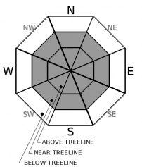
Moderate Avalanche Danger will exist as continued high winds affect our region today and tonight.  Wind slab avalanches will be possible in near and above treeline terrain.  Low Avalanche Danger will exist in below treeline terrain.

2. Moderate

?

Above Treeline
Heightened avalanche conditions on specific terrain features. Evaluate snow and terrain carefully; identify features of concern.

2. Moderate

?

Near Treeline
Heightened avalanche conditions on specific terrain features. Evaluate snow and terrain carefully; identify features of concern.

1. Low

?

Below Treeline
Generally safe avalanche conditions. Watch for unstable snow on isolated terrain features.
    Heightened avalanche conditions on specific terrain features. Evaluate snow and terrain carefully; identify features of concern.
Avalanche Problem 1: Wind Slab
  • Type ?
  • Aspect/Elevation ?
  • Likelihood ?
    Certain
    Very Likely
    Likely
    Possible
    Unlikely
  • Size ?
    Historic
    Very Large
    Large
    Small

Wind slab avalanches will be possible on all aspects in near treeline and above treeline terrain.  Strong to gale force NE/E winds yesterday will decrease into today before shifting to the West tonight and increasing back in speed.  Wind slabs will continue to build on S-SW-W aspects through today.  Many N-NE-E wind exposed aspects will continue to be scoured today before being reloaded tonight as the winds change to the West.  Some of these wind slabs may be sitting on top of old weak surface snow.

Look for blowing snow and cornice formation.  Winds will continue to redistribute snow and scour other areas down to old firm snow surfaces.  Wind protected, below treeline terrain, will provide some of the best options for finding soft snow away from the wind slab instabilities.

recent observations

*  Strong to gale force NE/E winds were transporting snow on Castle Peak (Donner Summit area), Tamarack Peak (Mt. Rose area), and Thunder Mountain (Carson Pass area).  8 to 10'' of new storm snow was reported from the Fireplug area near Tamarack Peak.  Unstable snowpack test results were reported from Castle Peak, with snow transport and new cornice formation on multiple aspects.

*  Near crust faceting was observed in the old snow below the recent storm snow in the Carson Pass area and in the Independence Lake area.  This weak snow was seen below the most recent rain crust

Weather and CURRENT CONDITIONS
weather summary

A short break today with decreasing N/NE winds and increasing clouds.  A cold front drops into the area tonight with increasing winds, light snow possible, and cold air.  This cold air should stay with us through the week with below zero wind chills expected for Thursday and Friday.  

CONDITIONS ALONG THE SIERRA CREST BETWEEN 8200 FT. AND 9200 FT. IN THE LAST 24 HOURS
6am temperature: 17 to 20 deg. F.
Max. temperature: 26 deg. F.
Average ridgetop wind direction: NE to E
Average ridgetop wind speed: 30 to 50 mph
Maximum ridgetop wind gust: 83 mph
New snowfall: 0 to Trace inches
Total snow depth: 32 to 40 inches
Two-Day Mountain Weather Forecast Produced in partnership with the Reno NWS
For 7000 ft. to 8000 ft.
Wednesday Wednesday Night Thursday
Weather: Partly cloudy. Snow levels below 7000 feet. Chance of precipitation is 0%. Partly cloudy then becoming mostly cloudy. Slight chance of snow showers after midnight. Snow levels below 7000 feet. Chance of precipitation is 15%. Mostly cloudy. Slight chance of snow showers. Snow levels below 7000 feet. Chance of precipitation is 20%.
Temperatures: 36 to 41. deg. F. 15 to 23. deg. F. 23 to 28. deg. F.
Mid Slope Winds: Light winds. Light winds becoming west 10 to 15 mph after midnight. Gusts up to 30 mph. North 10 to 15 mph with gusts to 35 mph.
Expected snowfall: No accumulation. | SWE = none. Trace amounts. | SWE = trace amounts. Trace amounts. | SWE = trace amounts.
For 8000 ft. to 9000 ft.
Wednesday Wednesday Night Thursday
Weather: Partly cloudy. Snow levels below 7000 feet. Chance of precipitation is 0%. Partly cloudy then becoming mostly cloudy. Slight chance of snow showers after midnight. Snow levels below 7000 feet. Chance of precipitation is 15%. Mostly cloudy. Slight chance of snow showers. Snow levels below 7000 feet. Chance of precipitation is 20%.
Temperatures: 33 to 38. deg. F. 13 to 19. deg. F. 19 to 24. deg. F.
Ridge Top Winds: North 15 to 25 mph. Gusts up to 50 mph decreasing to 40 mph in the afternoon. West 15 to 30 mph. Gusts up to 45 mph increasing to 60 mph after midnight. North 15 to 30 mph with gusts to 50 mph.
Expected snowfall: No accumulation. | SWE = none. Trace amounts. | SWE = trace amounts. Trace amounts. | SWE = trace amounts.
Disclaimer

This avalanche forecast is provided through a partnership between the Tahoe National Forest and the Sierra Avalanche Center. This forecast covers the Central Sierra Nevada Mountains between Yuba Pass on the north and Ebbetts Pass on the south. Click here for a map of the forecast area. This forecast applies only to backcountry areas outside established ski area boundaries. This forecast describes general avalanche conditions and local variations always occur. This forecast expires 24 hours after the posted time unless otherwise noted. The information in this forecast is provided by the USDA Forest Service who is solely responsible for its content.

For a recorded version of the avalanche forecast call (530) 587-3558 x258