THIS AVALANCHE FORECAST EXPIRED ON December 29, 2018 @ 6:47 am
Avalanche Forecast published on December 28, 2018 @ 6:47 am
Issued by Brandon Schwartz - Tahoe National Forest

MODERATE avalanche danger continues near treeline and above treeline in specific areas where blowing snow has formed new wind slabs. In wind protected areas below treeline, LOW avalanche danger exists.

2. Moderate

?

Above Treeline
Heightened avalanche conditions on specific terrain features. Evaluate snow and terrain carefully; identify features of concern.

2. Moderate

?

Near Treeline
Heightened avalanche conditions on specific terrain features. Evaluate snow and terrain carefully; identify features of concern.

1. Low

?

Below Treeline
Generally safe avalanche conditions. Watch for unstable snow on isolated terrain features.
    Heightened avalanche conditions on specific terrain features. Evaluate snow and terrain carefully; identify features of concern.
Avalanche Problem 1: Wind Slab
  • Type ?
  • Aspect/Elevation ?
  • Likelihood ?
    Certain
    Very Likely
    Likely
    Possible
    Unlikely
  • Size ?
    Historic
    Very Large
    Large
    Small

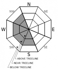
Ridgetop winds out of the NE increased last night with gusts to 98 mph. This will have further scoured N-NE-E aspects. Redistributed snow will allow for newly formed wind slabs near and above treeline on some S-SW-W-NW aspects. NW aspects may be the most concerning due to a mix of new loading on top of faceted snow. For the most part, avalanche size is expected to be small (size D1) with the isolated possibility of avalanches large enough to bury or injure a person (size D2).

Determine which slopes have elevated hazard and make travel decisions accordingly. Identify slopes where recently drifted snow has accumulated. Look for wind pillows, new cornices, and snow surface texturing. Today's wind slabs may take on hard slab characteristics. The best opportunity to avoid this avalanche problem and find soft snow will be in wind protected areas below treeline.

recent observations

* Moderate amounts of blowing snow were noted in ridgetop locations over the past 24 hours.

* Firm ice may be encountered in some heavily wind scoured locations.

* The snowpack continues to facet in many locations, especially on northerly aspects that hold a shallow snowpack. This remains a monitoring concern up to the next new snow loading event.

Weather and CURRENT CONDITIONS
weather summary

A gale force NE wind event will continue to affect the forecast area through today. Colder than average air temperatures will continue as well. Clearing skies are expected today. NE ridgetop winds are forecast to begin to decrease on Saturday with continued sunny skies and warmer maximum daytime air temperatures.

CONDITIONS ALONG THE SIERRA CREST BETWEEN 8200 FT. AND 9200 FT. IN THE LAST 24 HOURS
6am temperature: 7 to 12 deg. F.
Max. temperature: 15 to 21 deg. F.
Average ridgetop wind direction: NE
Average ridgetop wind speed: 61 mph
Maximum ridgetop wind gust: 98 mph
New snowfall: 0 to 1 inches
Total snow depth: 32 to 37 inches
Two-Day Mountain Weather Forecast Produced in partnership with the Reno NWS
For 7000 ft. to 8000 ft.
Friday Friday Night Saturday
Weather: Partly cloudy then becoming sunny. Snow levels below 7000 feet. Chance of precipitation is 5%. Clear. Snow levels below 7000 feet. Chance of precipitation is 0%. Sunny. Snow levels below 7000 feet. Chance of precipitation is 0%.
Temperatures: 22 to 28. deg. F. 9 to 15. deg. F. 36 to 41. deg. F.
Mid Slope Winds: Northeast 10 to 15 mph with gusts to 40 mph. Northeast 10 to 15 mph with gusts to 35 mph. East 10 to 15 mph with gusts to 30 mph in the morning becoming light.
Expected snowfall: No accumulation. | SWE = none. No accumulation. | SWE = none. No accumulation. | SWE = none.
For 8000 ft. to 9000 ft.
Friday Friday Night Saturday
Weather: Partly cloudy then becoming sunny. Snow levels below 7000 feet. Chance of precipitation is 5%. Clear. Snow levels below 7000 feet. Chance of precipitation is 0%. Sunny. Snow levels below 7000 feet. Chance of precipitation is 0%.
Temperatures: 20 to 25. deg. F. 9 to 15. deg. F. 34 to 39. deg. F.
Ridge Top Winds: Northeast 25 to 35 mph with gusts to 85 mph. Northeast 20 to 35 mph with gusts to 75 mph. Northeast 15 to 30 mph. Gusts up to 65 mph decreasing to 45 mph in the afternoon.
Expected snowfall: No accumulation. | SWE = none. No accumulation. | SWE = none. No accumulation. | SWE = none.
Disclaimer

This avalanche forecast is provided through a partnership between the Tahoe National Forest and the Sierra Avalanche Center. This forecast covers the Central Sierra Nevada Mountains between Yuba Pass on the north and Ebbetts Pass on the south. Click here for a map of the forecast area. This forecast applies only to backcountry areas outside established ski area boundaries. This forecast describes general avalanche conditions and local variations always occur. This forecast expires 24 hours after the posted time unless otherwise noted. The information in this forecast is provided by the USDA Forest Service who is solely responsible for its content.

For a recorded version of the avalanche forecast call (530) 587-3558 x258