THIS AVALANCHE FORECAST EXPIRED ON December 4, 2018 @ 6:57 am
Avalanche Forecast published on December 3, 2018 @ 6:57 am
Issued by Andy Anderson - Tahoe National Forest - Sierra Avalanche Center

MODERATE avalanche danger exists at all elevations today. Human triggered avalanches remain possible. Some unstable storm slabs and wind slabs may still linger in some areas. If any doubts exist about the stability of a slope, avoid it and move on to something lower angle with less uncertainty.

2. Moderate

?

Above Treeline
Heightened avalanche conditions on specific terrain features. Evaluate snow and terrain carefully; identify features of concern.

2. Moderate

?

Near Treeline
Heightened avalanche conditions on specific terrain features. Evaluate snow and terrain carefully; identify features of concern.

2. Moderate

?

Below Treeline
Heightened avalanche conditions on specific terrain features. Evaluate snow and terrain carefully; identify features of concern.
    Heightened avalanche conditions on specific terrain features. Evaluate snow and terrain carefully; identify features of concern.
Avalanche Problem 1: Storm Slab
  • Type ?
  • Aspect/Elevation ?
  • Likelihood ?
    Certain
    Very Likely
    Likely
    Possible
    Unlikely
  • Size ?
    Historic
    Very Large
    Large
    Small

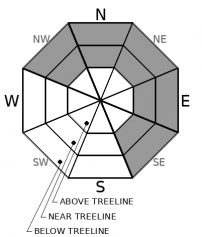
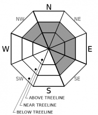
As the skier-triggered avalanche from yesterday highlights, some lingering unstable storm slabs may still exist in near and below treeline terrain especially if they rest on top of a thin weak layer of surface hoar. A high degree of uncertainty exists as to where these storm slabs may linger and whether or not they remain unstable. Triggering one of these storm slabs may be easier in areas with numerous trigger points (like convex rollovers, shallowly buried rocks, cliffy areas, etc) or in more complex terrain. They could potentially involve enough snow to bury or injure a person especially in areas around terrain traps

Recent avalanches, shooting cracks or collapses, or unstable snowpit tests can all help identify where unstable storm slabs may still exist. Actively look for signs of instability and avoid areas with potential problems. In some cases, this problem could lurk in an area where most data seems to indicate stability. If in doubt, assume a slope could remain unstable and avoid it. The high degree uncertainty associated with this problem makes more conservative decision making a good strategy. Low angle slopes are holding great snow and provide less potential for hitting barely covered obstacles.

Avalanche Problem 2: Wind Slab
  • Type ?
  • Aspect/Elevation ?
  • Likelihood ?
    Certain
    Very Likely
    Likely
    Possible
    Unlikely
  • Size ?
    Historic
    Very Large
    Large
    Small

Wind slab avalanches should have become more difficult to trigger in most places. However, some human-triggered wind slab avalanches may remain possible today in near and above treeline areas on wind-loaded N-NE-E aspects and cross-loaded NW and SE aspects. Avalanches resulting from these wind slabs could involve enough snow to bury a person (size D2). Like the storm slabs mentioned above, triggering these lingering wind slabs could be easier in more complex terrain with numerous trigger points.

Use clues like cornices above slopes, wind pillows/drifts, ripples on the snow surface, and other signs of wind-loading to identify and then avoid places where wind slabs may exist. Plenty of great snow and recreation opportunities exist on lower angle more sheltered slopes.

recent observations

* A skier-triggered avalanche occurred on a 35 degree, NE facing slope at 9400 ft. on Red Lake Peak yesterday. One skier was caught, but not buried. No injuries resulted. For more information click here or on the observation below. The weak layer remains unknown, but the party who triggered it speculated that it may have been a lingering patch of buried surface hoar

* Surface hoar (weak feathery snow crystals) had formed on the current snow surface on all aspects and elevations on Elephant's Hump.

* Good snow coverage exists in many places, but there are still many obstacles/trigger points on or near the snow surface in some areas.  

Weather and CURRENT CONDITIONS
weather summary

A weak and short-lived high-pressure ridge will bring sunny skies to the forecast area today. Winds should remain light and temperatures should warm some compared to yesterday with highs in the upper 20's to low 30's above 7000 ft. By tonight some cloud cover should start to build back over the region as a small storm system approaches the area. By tomorrow the forecast area could see the return of light snow showers. The forecast calls for limited accumulation with only up to 2 inches of new snow expected during the day tomorrow. Winds should remain light through tomorrow.

CONDITIONS ALONG THE SIERRA CREST BETWEEN 8200 FT. AND 9200 FT. IN THE LAST 24 HOURS
6am temperature: 3 to 11 deg. F.
Max. temperature: 21 to 25 deg. F.
Average ridgetop wind direction: Variable
Average ridgetop wind speed: 5 to 10 mph
Maximum ridgetop wind gust: 27 mph
New snowfall: Trace to 1 inches
Total snow depth: 31 to 41 inches
Two-Day Mountain Weather Forecast Produced in partnership with the Reno NWS
For 7000 ft. to 8000 ft.
Monday Monday Night Tuesday
Weather: Sunny. Partly cloudy then becoming mostly cloudy. Isolated snow showers after midnight. Snow levels below 7000 feet. Chance of precipitation is 30%. Cloudy. Scattered snow showers. Snow levels below 7000 feet. Chance of precipitation is 50%.
Temperatures: 28 to 33 deg. F. 20 to 26 deg. F. 28 to 33 deg. F.
Mid Slope Winds: Light winds. Light winds. Light winds.
Expected snowfall: No accumulation. 50% probability up to 1 inch. 50% probability no accumulation. | SWE = less than 0.10 inch. up to 2 inches. | SWE = 0.05 to 0.10 inch.
For 8000 ft. to 9000 ft.
Monday Monday Night Tuesday
Weather: Sunny. Partly cloudy then becoming mostly cloudy. Isolated snow showers after midnight. Snow levels below 7000 feet. Chance of precipitation is 35%. Cloudy. Scattered snow showers. Snow levels below 7000 feet. Chance of precipitation is 50%.
Temperatures: 25 to 31 deg. F. 20 to 25 deg. F. 26 to 32 deg. F.
Ridge Top Winds: Light winds becoming south 10 to 15 mph in the afternoon. Gusts up to 25 mph. South to southeast 10 to 15 mph with gusts up to 30 mph. East 10 to 15 mph with gusts to 30 mph.
Expected snowfall: No accumulation. 60% probability up to 1 inch. 40% probability no accumulation. | SWE = less than 0.10 inch. up to 2 inches. | SWE = up to 0.15 inch.
Disclaimer

This avalanche advisory is provided through a partnership between the Tahoe National Forest and the Sierra Avalanche Center. This advisory covers the Central Sierra Nevada Mountains between Yuba Pass on the north and Ebbetts Pass on the south. Click here for a map of the forecast area. This advisory applies only to backcountry areas outside established ski area boundaries. This advisory describes general avalanche conditions and local variations always occur. This advisory expires 24 hours after the posted time unless otherwise noted. The information in this advisory is provided by the USDA Forest Service who is solely responsible for its content.

For a recorded version of the Avalanche Advisory call (530) 587-3558 x258