THIS AVALANCHE FORECAST EXPIRED ON December 5, 2018 @ 6:59 am
Avalanche Forecast published on December 4, 2018 @ 6:59 am
Issued by Andy Anderson - Tahoe National Forest - Sierra Avalanche Center

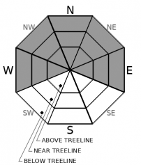
The avalanche danger will remain at MODERATE today due to the possibility of unstable storm slabs still lingering in some areas. Significant uncertainty remains concerning these storm slabs. If any doubts exist about the stability of a slope, avoid it and move on to something lower angle with less uncertainty. New snow expected tonight may allow storm slabs to become more widespread.

2. Moderate

?

Above Treeline
Heightened avalanche conditions on specific terrain features. Evaluate snow and terrain carefully; identify features of concern.

2. Moderate

?

Near Treeline
Heightened avalanche conditions on specific terrain features. Evaluate snow and terrain carefully; identify features of concern.

2. Moderate

?

Below Treeline
Heightened avalanche conditions on specific terrain features. Evaluate snow and terrain carefully; identify features of concern.
    Heightened avalanche conditions on specific terrain features. Evaluate snow and terrain carefully; identify features of concern.
Avalanche Problem 1: Storm Slab
  • Type ?
  • Aspect/Elevation ?
  • Likelihood ?
    Certain
    Very Likely
    Likely
    Possible
    Unlikely
  • Size ?
    Historic
    Very Large
    Large
    Small

Areas where storm slabs may remain possible should have become more isolated. However, continued signs of instability in near and below treeline terrain in some areas (specifically Red Lake Peak) indicate that some unstable storm slabs could still linger in a few places. Given the high degree of uncertainty as to where these storm slabs may linger and whether or not they remain unstable, they still warrant inclusion as a potential avalanche problem. Triggering one of these storm slabs may be easier in areas with numerous trigger points (like convex rollovers, shallowly buried rocks, cliffy areas, etc) or in more complex terrain. They could potentially involve enough snow to bury or injure a person especially in areas around terrain traps. Depending on the amount of new snow that accumulates tonight, storm slabs may become more widespread and reach into above treeline terrain. 

Recent avalanches, shooting cracks or collapses, or unstable snowpit tests can all help identify where unstable storm slabs may still exist. Actively look for signs of instability and avoid areas with potential problems. In some cases, this problem could lurk in an area where most data seems to indicate stability. If in doubt, assume a slope could remain unstable and avoid it. The high degree uncertainty associated with this problem makes more conservative decision making a good strategy. Low angle slopes are holding great snow and provide less potential for hitting barely covered obstacles.

Forecast discussion

The limited amount of new snow expected today should not be enough to create new storm slabs, but it could bury the layer of fragile feathery crystals (surface hoar) that currently exists on the snow surface. Buried surface hoar would provide a notoriously weak layer that could allow avalanches to propagate farther across slopes, travel farther down slopes, and break into some less steep terrain. It will not take much new snow to overload that weak layer. If we reach the higher end of forecasted snow totals tonight, more widespread human-triggerable avalanche activity could become possible during the night and by tomorrow morning. If we do not get enough snow to overload that layer, it could linger below the surface and serve as a buried weak layer in a future storm. Tracking where this surface hoar exists and what slopes it may get buried on will help inform where future instability may lurk. If you are out today, please send in your observations to help map this layer

recent observations

* Yesterday, observers on Red Lake Peak (Carson Pass) continued to see unstable test results and some skier-triggered shooting cracks in terrain similar to where the skier triggered avalanche occurred. 

* Snowpit data from Mt. Judah (Donner Summit) did find a patch of buried surface hoar about 20 cm below the surface in one N facing opening at 7900 ft. Snowpit tests targeting this layer did not reveal ongoing signs of instability yesterday.

* Observations from Red Lake Peak, Mt. Judah, Rubicon Peak (West Shore), and Slab Cliffs (Mt. Rose backcountry) all reported widespread surface hoar on all but the southerly aspects at all elevations.

* Decent snow coverage exists in many places, but it is still early season and there are still many obstacles/trigger points on or near the snow surface.  

Weather and CURRENT CONDITIONS
weather summary

Some light snow flurries started in a few places early this morning with no accumulation. Some intermittent snow flurries may continue through the day, but accumulations should remain limited. Snow showers should increase this evening as a small weak storm system moves into the area. The forecast calls for up to 4 inches of snow during the night with light winds in most areas. Snowfall and light winds should continue into tomorrow with a chance for up to 2 more inches of accumulation. The forecast calls for the snow to taper off by tomorrow evening.   

CONDITIONS ALONG THE SIERRA CREST BETWEEN 8200 FT. AND 9200 FT. IN THE LAST 24 HOURS
6am temperature: 19 to 24 deg. F.
Max. temperature: 23 to 29 deg. F.
Average ridgetop wind direction: SW
Average ridgetop wind speed: 10 to 20 mph
Maximum ridgetop wind gust: 39 mph
New snowfall: trace to 0 inches
Total snow depth: 28 to 38 inches
Two-Day Mountain Weather Forecast Produced in partnership with the Reno NWS
For 7000 ft. to 8000 ft.
Tuesday Tuesday Night Wednesday
Weather: Cloudy. Scattered snow showers. Snow levels below 6500 feet. Chance of precipitation is 40%. Snow. Snow levels below 6500 feet. Chance of precipitation is 80%. Cloudy. Snow showers likely. Snow levels below 6500 feet. Chance of precipitation is 70%.
Temperatures: 27 to 32. deg. F. 22 to 27. deg. F. 28 to 33. deg. F.
Mid Slope Winds: East to southeast around 10 mph. East to southeast around 10 mph. Light winds.
Expected snowfall: up to 1 inch. | SWE = less than 0.10 inch 80% probability of 1 to 3 inches. 20% probability of up to 1 inch. | SWE = up to 0.25 inch 60% probability up to 2 inches. 40% probability of no accumulation. | SWE = up to 0.15 inch.
For 8000 ft. to 9000 ft.
Tuesday Tuesday Night Wednesday
Weather: Cloudy. Scattered snow showers. Snow levels below 6500 feet. Chance of precipitation is 40%. Cloudy. Snow. Snow levels below 6500 feet. Chance of precipitation is 90%. Cloudy. Snow showers likely. Snow levels below 6500 feet. Chance of precipitation is 70%.
Temperatures: 24 to 29. deg. F. 20 to 25. deg. F. 25 to 30. deg. F.
Ridge Top Winds: Southeast 10 to 20 mph. Gusts up to 30 mph. Southeast 10 to 20 mph. Gusts up to 25 mph increasing to 35 mph after midnight. South 15 to 20 mph. Gusts up to 40 mph decreasing to 30 mph in the afternoon.
Expected snowfall: up to 1 inch. | SWE = less than 0.10 inch 80% probability of 2 to 4 inches. 20% probability of up to 2 inches. | SWE = up to 0.25 inch 60% probability of 1 to 3 inches. 40% probability of up to 1 inch. | SWE = up to 0.15 inch
Disclaimer

This avalanche advisory is provided through a partnership between the Tahoe National Forest and the Sierra Avalanche Center. This advisory covers the Central Sierra Nevada Mountains between Yuba Pass on the north and Ebbetts Pass on the south. Click here for a map of the forecast area. This advisory applies only to backcountry areas outside established ski area boundaries. This advisory describes general avalanche conditions and local variations always occur. This advisory expires 24 hours after the posted time unless otherwise noted. The information in this advisory is provided by the USDA Forest Service who is solely responsible for its content.

For a recorded version of the Avalanche Advisory call (530) 587-3558 x258