THIS AVALANCHE FORECAST EXPIRED ON December 6, 2018 @ 6:59 am
Avalanche Forecast published on December 5, 2018 @ 6:59 am
Issued by Steve Reynaud - Tahoe National Forest

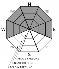
Moderate Avalanche danger will exist throughout the forecast region today due to a persistent slab avalanche problem.  Widespread surface hoar has been reported throughout the area this past week.  Light amounts of new snow occurred overnight and are expected into tomorrow.  Most avalanches associated with this buried surface hoar are expected to be small, but even small avalanches can have severe consequences with our early season snow coverage.  Evaluate snow and terrain carefully today, identify areas of concern.    

2. Moderate

?

Above Treeline
Heightened avalanche conditions on specific terrain features. Evaluate snow and terrain carefully; identify features of concern.

2. Moderate

?

Near Treeline
Heightened avalanche conditions on specific terrain features. Evaluate snow and terrain carefully; identify features of concern.

2. Moderate

?

Below Treeline
Heightened avalanche conditions on specific terrain features. Evaluate snow and terrain carefully; identify features of concern.
    Heightened avalanche conditions on specific terrain features. Evaluate snow and terrain carefully; identify features of concern.
Avalanche Problem 1: Persistent Slab
  • Type ?
  • Aspect/Elevation ?
  • Likelihood ?
    Certain
    Very Likely
    Likely
    Possible
    Unlikely
  • Size ?
    Historic
    Very Large
    Large
    Small

Widespread surface hoar has been observed in many areas throughout our forecast region.  This surface hoar today has up to 4'' of new storm snow on top of it with another 1 to 3'' expected today.  This small amount of new snow should not be enough today to bury a backcountry user, but could be enough to take someone on a ride into low snow covered obstacles.  You should not be surprise to see small avalanches today.  These avalanches will mostly be in the form of small loose dry (sluffing) avalanches due to no cohesion of the new storm snow.  In areas that receive the most snow, small persistent slabs could occur.

Identify where the surface hoar exists throughout the terrain.  Quick hand pits should aid in seeing the surface hoar layer.  This will be important for today and potentially the future when our next storm arrives.  Please let us know what you see.  If your field observations show either more storm snow than forecasted or a potential wind slab on top of the buried surface hoar-you should reevaluate your plan and choose safer terrain options.     

recent observations

*  Large widespread surface hoar reported on Silver Peak (Pole Creek area,)  Mt. Judah (Donner Summit area), and on Rubicon Peak (West Shore area) over the last 2 days.  Reports of surface hoar came in from Carson Pass and Mt. Rose over the last 4 days.

*  Signs of previous storm slab instabilities have diminished over the last 2 days.  No additional avalanches reported. 

*  Decent snow coverage exists above 7000-7500' along the Sierra Crest with slightly more coverage in the northern Sierra Crest part of the forecast area.  Snow coverage declines as you move east.  Early season conditions still exist.  Many obstacles are present including; rocks, logs, stumps, and open water.

Weather and CURRENT CONDITIONS
weather summary

Light snow will continue today and into Thursday before tapering off.  1 to 4'' of new snow fell overnight with 1 to 3'' of snow forecasted today with up to 2'' forecasted tonight.  Winds will be generally light from the SE.  Temperatures will remain cold for today through Thursday.  Dry weather with milder temperatures are expected Friday through the weekend.  Another storm is forecasted with snow and rain early next week.

CONDITIONS ALONG THE SIERRA CREST BETWEEN 8200 FT. AND 9200 FT. IN THE LAST 24 HOURS
6am temperature: 21 to 24 deg. F.
Max. temperature: 28 deg. F.
Average ridgetop wind direction: E to SE
Average ridgetop wind speed: 5 to 15 mph
Maximum ridgetop wind gust: 34 mph
New snowfall: 1 to 4 inches
Total snow depth: 29 to 37 inches
Two-Day Mountain Weather Forecast Produced in partnership with the Reno NWS
For 7000 ft. to 8000 ft.
Wednesday Wednesday Night Thursday
Weather: Mostly cloudy. Widespread snow before 8 AM, then scattered snow showers in the afternoon. Snow levels below 7000 feet. Chance of precipitation is 90%. Cloudy. Scattered snow showers. Snow levels below 7000 feet. Chance of precipitation is 40%. Mostly cloudy then becoming partly cloudy. Isolated snow showers south of Highway 50. Snow levels below 7000 feet. Chance of precipitation is 10%.
Temperatures: 28 to 33. deg. F. 19 to 24. deg. F. 29 to 34. deg. F.
Mid Slope Winds: Southeast up to 10 mph. East around 10 mph. Light winds.
Expected snowfall: 70% probability of 1 to 3 inches. 30% probability up to 1 inch. | SWE = up to 0.20 inch. up to 1 inch. | SWE = less than 0.10 inch. Little or no accumulation. | SWE = trace.
For 8000 ft. to 9000 ft.
Wednesday Wednesday Night Thursday
Weather: Mostly cloudy. Widespread snow before 8 AM, then scattered snow showers in the afternoon. Snow levels below 7000 feet. Chance of precipitation is 90%. Cloudy. Widespread snow showers in the evening, then scattered snow showers after midnight. Snow levels below 7000 feet. Chance of precipitation is 60%. Mostly cloudy. Isolated snow showers south of Highway 50. Snow levels below 7000 feet. Chance of precipitation is 15%.
Temperatures: 25 to 31. deg. F. 18 to 23. deg. F. 25 to 30. deg. F.
Ridge Top Winds: Southeast 10 to 15 mph. Gusts up to 25 mph. East 10 to 20 mph. East around 10 mph.
Expected snowfall: 70% probability of 1 to 3 inches. 30% probability up to 1 inch. | SWE = up to 0.20 inch. up to 2 inches. | SWE = up to 0.15 inch. Little or no accumulation. | SWE = trace amounts.
Disclaimer

This avalanche advisory is provided through a partnership between the Tahoe National Forest and the Sierra Avalanche Center. This advisory covers the Central Sierra Nevada Mountains between Yuba Pass on the north and Ebbetts Pass on the south. Click here for a map of the forecast area. This advisory applies only to backcountry areas outside established ski area boundaries. This advisory describes general avalanche conditions and local variations always occur. This advisory expires 24 hours after the posted time unless otherwise noted. The information in this advisory is provided by the USDA Forest Service who is solely responsible for its content.

For a recorded version of the Avalanche Advisory call (530) 587-3558 x258