THIS AVALANCHE FORECAST EXPIRED ON December 7, 2018 @ 6:45 am
Avalanche Forecast published on December 6, 2018 @ 6:45 am
Issued by Steve Reynaud - Tahoe National Forest

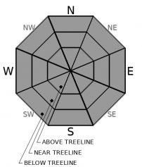
Low avalanche danger is expected throughout the forecast area today.  Buried surface hoar exists under 3-5'' of storm snow from yesterday in many areas, but this small amount of additional load is not enough to warrant an avalanche concern at this time.  Normal caution is advised in the backcountry today.

1. Low

?

Above Treeline
Generally safe avalanche conditions. Watch for unstable snow on isolated terrain features.

1. Low

?

Near Treeline
Generally safe avalanche conditions. Watch for unstable snow on isolated terrain features.

1. Low

?

Below Treeline
Generally safe avalanche conditions. Watch for unstable snow on isolated terrain features.
    Generally safe avalanche conditions. Watch for unstable snow on isolated terrain features.
Avalanche Problem 1: Normal Caution
  • Type ?
  • Aspect/Elevation ?

The Dec. 4th buried surface hoar layer is now under 3-5'' of storm snow.  This small amount of new load is not enough to cause failure of the layer or become a cohesive slab at this point.  Unfortunately, this new storm snow will add some protection to the buried surface hoar which could make it harder to destroy before additional storms overload the weak layer.  Small loose dry avalanches will continue to be possible in steep terrain. 

Continue to practice safe travel protocols:  have a travel plan, travel one at a time through avalanche terrain, regroup out of avalanche terrain away from runout zones, and communicate with your partners.  

recent observations

*  Buried surface hoar was found on Silver Peak (Pole Creek area) yesterday.  This buried surface hoar was found under 3-5'' of new storm snow.  Snowpack tests and informal observations showed that this load is not sufficient to create any avalanche concerns at this point.  Small loose dry avalanches occurred in steep northerly terrain.

*  Decent snow coverage exists above 7000-7500' along the Sierra Crest with slightly more coverage in the northern Sierra Crest part of the forecast area.  Snow coverage declines as you move east.  Early season conditions still exist.  Many obstacles are present including; rocks, logs, stumps, and open water.

Weather and CURRENT CONDITIONS
weather summary

Mostly cloudy conditions today with a chance of light snow showers.  The possibility of snow showers will be mostly in the southern portion of the forecast region.  Friday through the weekend will be dry with milder temperatures.  A chance of a smaller storm exists for early next week, with the weather pattern continuing to look active through mid month. 

CONDITIONS ALONG THE SIERRA CREST BETWEEN 8200 FT. AND 9200 FT. IN THE LAST 24 HOURS
6am temperature: 21 to 27 deg. F.
Max. temperature: 34 deg. F.
Average ridgetop wind direction: E to SE
Average ridgetop wind speed: 5 to 15 mph
Maximum ridgetop wind gust: 27 mph
New snowfall: Trace to 3 inches
Total snow depth: 30 to 39 inches
Two-Day Mountain Weather Forecast Produced in partnership with the Reno NWS
For 7000 ft. to 8000 ft.
Thursday Thursday Night Friday
Weather: Mostly cloudy. Isolated snow showers. Snow levels below 7000 feet. Chance of precipitation is 15%. Partly cloudy. Snow levels below 7000 feet. Chance of precipitation is 10%. Sunny. Snow levels below 7000 feet. Chance of precipitation is 0%.
Temperatures: 28 to 33. deg. F. 14 to 22. deg. F. 33 to 38. deg. F.
Mid Slope Winds: Light winds. Light winds. Light winds.
Expected snowfall: 70% probability up to 1 inch. 30% probability 1 to 3 inches. | SWE = trace amounts. No accumulation. | SWE = none. No accumulation. | SWE = none.
For 8000 ft. to 9000 ft.
Thursday Thursday Night Friday
Weather: Mostly cloudy. Isolated snow showers through the day. Snow levels below 7000 feet. Chance of precipitation is 20%. Partly cloudy. Snow levels below 7000 feet. Chance of precipitation is 10%. Sunny. Snow levels below 7000 feet. Chance of precipitation is 0%.
Temperatures: 25 to 31. deg. F. 13 to 18. deg. F. 30 to 35. deg. F.
Ridge Top Winds: Light winds. Light winds. Light winds.
Expected snowfall: 70% probability up to 1 inch. 30% probability 1 to 3 inches. | SWE = trace amounts. Little or no accumulation. | SWE = none. No accumulation. | SWE = none.
Disclaimer

This avalanche advisory is provided through a partnership between the Tahoe National Forest and the Sierra Avalanche Center. This advisory covers the Central Sierra Nevada Mountains between Yuba Pass on the north and Ebbetts Pass on the south. Click here for a map of the forecast area. This advisory applies only to backcountry areas outside established ski area boundaries. This advisory describes general avalanche conditions and local variations always occur. This advisory expires 24 hours after the posted time unless otherwise noted. The information in this advisory is provided by the USDA Forest Service who is solely responsible for its content.

For a recorded version of the Avalanche Advisory call (530) 587-3558 x258