THIS AVALANCHE FORECAST EXPIRED ON February 14, 2018 @ 6:57 am
Avalanche Forecast published on February 13, 2018 @ 6:57 am
Issued by Andy Anderson - Tahoe National Forest - Sierra Avalanche Center

The avalanche danger should remain LOW today on a regional scale. Some very small, shallow wind slabs may exist on a few isolated terrain features in the most heavily wind-loaded areas in near and above treeline terrain.

1. Low

?

Above Treeline
Generally safe avalanche conditions. Watch for unstable snow on isolated terrain features.

1. Low

?

Near Treeline
Generally safe avalanche conditions. Watch for unstable snow on isolated terrain features.

1. Low

?

Below Treeline
Generally safe avalanche conditions. Watch for unstable snow on isolated terrain features.
    Generally safe avalanche conditions. Watch for unstable snow on isolated terrain features.
Avalanche Problem 1: Wind Slab
  • Type ?
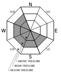
  • Aspect/Elevation ?
  • Likelihood ?
    Certain
    Very Likely
    Likely
    Possible
    Unlikely
  • Size ?
    Historic
    Very Large
    Large
    Small

Due to the minor amounts of new snow received over the last 36 hours, avalanche activity large enough to bury a person should remain unlikely on a regional scale again today. In isolated areas where the most new snow fell and the most E-NE wind-loading occurred, some small wind slabs may exist near ridgelines on isolated terrain features. The exposed NW aspects represent the best places to find these isolated small wind slabs, but they may also exist on W-SW-S-SE aspects in the few areas where there was previous snow cover on those aspects. Any of these wind slabs should remain very shallow and should not extend more than a few feet from the ridgelines. 

Other dangers like falls on frozen crusts / scoured surfaces, collisions with some of the numerous exposed obstacles, or both still exist. Continue to plan travel in the backcountry to minimize risks.

recent observations

* Small winds slabs existed on isolated NW aspects near ridgelines above Slab Cliffs (Mt. Rose backcountry) yesterday. Ski kicks on these small wind slabs did result in minor cracking. The largest of these wind slabs measured 4 to 6 inches in depth and only extended downslope from the ridgelines 12 to 18 inches.

*  Yesterday in the Incline Lake Peak and Slab Cliffs areas "dust on crust" conditions existed on any aspects (E-SE-S-SW-W) where firm melt-freeze crusts existed prior to the storm and "dust on breakable crusts" conditions existed on slopes (NE and NW and some N aspects) where breakable crusts existed prior to the storm.

* Some soft, cold, unconsolidated snow still lingered below the surface snow on sheltered untracked N aspects in the Slab Cliffs area yesterday. 


Weather and CURRENT CONDITIONS
weather summary

Snow showers continued throughout the day yesterday adding another 1 to 2 inches to the snowpack in most places. A few sensors mostly south of Emerald Bay reported 2 to 4 inches of new snow in the last 24 hours. The E and NE winds remained strong through the night. These winds should diminish today, and clear sunny weather should return to the region. By tomorrow SW winds and cloud cover should begin to increase as a small low-pressure system moves into the Great Basin.

CONDITIONS ALONG THE SIERRA CREST BETWEEN 8200 FT. AND 9200 FT. IN THE LAST 24 HOURS
6am temperature: 14 to 18 deg. F.
Max. temperature: 18 to 24 deg. F.
Average ridgetop wind direction: E and NE
Average ridgetop wind speed: 35 to 45 mph
Maximum ridgetop wind gust: 86 mph
New snowfall: 1 to 2 inches
Total snow depth: 29 to 49 inches
Two-Day Mountain Weather Forecast Produced in partnership with the Reno NWS
For 7000 ft. to 8000 ft.
Tuesday Tuesday Night Wednesday
Weather: Partly cloudy then becoming sunny Clear Partly cloudy then becoming mostly cloudy
Temperatures: 31 to 36 deg. F. 16 to 21 deg. F. 33 to 38 deg. F.
Mid Slope Winds: East Variable Southwest
Wind Speed: 10 to 15 mph with gusts to 30 mph in the morning becoming light in the afternoon Light 15 to 20 mph with gusts to 35 mph
Expected snowfall: 0 0 0
For 8000 ft. to 9000 ft.
Tuesday Tuesday Night Wednesday
Weather: Partly cloudy then becoming sunny Clear Partly cloudy then becoming mostly cloudy
Temperatures: 26 to 32 deg. F. 15 to 20 deg. F. 28 to 34 deg. F.
Ridge Top Winds: East Variable Southwest
Wind Speed: 25 to 35 mph with gusts to 60 mph decreasing to 10 to 15 mph in the afternoon with gusts to 35 mph Light 15 to 25 mph with gusts to 35 mph increasing to 45 mph in the afternoon
Expected snowfall: 0 0 0
Disclaimer

This avalanche advisory is provided through a partnership between the Tahoe National Forest and the Sierra Avalanche Center. This advisory covers the Central Sierra Nevada Mountains between Yuba Pass on the north and Ebbetts Pass on the south. Click here for a map of the forecast area. This advisory applies only to backcountry areas outside established ski area boundaries. This advisory describes general avalanche conditions and local variations always occur. This advisory expires 24 hours after the posted time unless otherwise noted. The information in this advisory is provided by the USDA Forest Service who is solely responsible for its content.

For a recorded version of the Avalanche Advisory call (530) 587-3558 x258