


For 7000 ft. to 8000 ft.
| Friday | Friday Night | Saturday | |
|---|---|---|---|
| Weather: | Sunny skies. | Clear skies. | Sunny skies. |
| Temperatures: | 40 to 45 deg. F. | 25 to 30 deg. F. | 43 to 48 deg. F. |
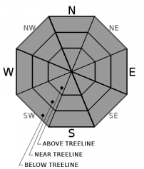
| Mid Slope Winds: | SW | Variable | SW |
| Wind Speed: | Light winds | Light winds | Light winds becoming 10 to 15 mph with gusts to 25 mph in the afternoon. |
| Expected snowfall: | 0 | 0 | 0 |
For 8000 ft. to 9000 ft.
| Friday | Friday Night | Saturday | |
|---|---|---|---|
| Weather: | Sunny skies. | Clear skies. | Sunny skies. |
| Temperatures: | 36 to 42 deg. F. | 24 to 29 deg. F. | 39 to 45 deg. F. |
| Ridge Top Winds: | SW | N | SW |
| Wind Speed: | 10 to 15 mph with gusts to 30 mph. | 10 to 15 mph with gusts to 25 mph in the evening, becoming light. | Light winds becoming 15 to 20 mph with gusts to 35 mph in the afternoon. |
| Expected snowfall: | 0 | 0 | 0 |


