


For 7000 ft. to 8000 ft.
| Thursday | Thursday Night | Friday | |
|---|---|---|---|
| Weather: | Cloudy skies with snow in the morning. Snow showers in the afternoon. | Mostly cloudy skies. Widespread snow showers in the evening. Scattered snow showers after midnight. | Partly cloudy skies with isolated snow showers. |
| Temperatures: | 18 to 24 deg. F. | 5 to 11 deg. F. | 21 to 26 deg. F. |
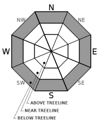
| Mid Slope Winds: | W | W shifting to N | NE |
| Wind Speed: | 15 to 25 mph. Gusts to 60 mph decreasing to 40 mph in the afternoon. | 10 to 15 mph with gusts up to 30 mph. | Generally light winds. Gusts to 25 mph in the afternoon. |
| Expected snowfall: | Likely 3 to 7 in. | Possible isolated areas of 7 to 12 | Likely 1 to 4 in .| Small chance 4 to 6 | 0 to trace |
For 8000 ft. to 9000 ft.
| Thursday | Thursday Night | Friday | |
|---|---|---|---|
| Weather: | Cloudy skies with snow in the morning. Snow showers in the afternoon. | Mostly cloudy skies. Widespread snow showers in the evening. Scattered snow showers after midnight. | Partly cloudy skies with isolated snow showers. |
| Temperatures: | 9 to 15 deg. F. | 0 to 8 deg. F. | 13 to 19 deg. F. |
| Ridge Top Winds: | SW to W | NW | NE |
| Wind Speed: | 25 to 40 mph with gusts to 80 mph, decreasing to 15 to 25 mph with gusts to 45 mph in the afternoon. | 10 to 15 mph with gusts to 30 mph. | 10 to 15 mph. Gusts up to 30 mph in the afternoon. |
| Expected snowfall: | Likely 3 to 7 in. | Possible isolated areas of 7 to 12 | Likely 1 to 4 in. | Small chance 4 to 6 | 0 to trace |


