THIS AVALANCHE FORECAST EXPIRED ON March 1, 2018 @ 6:55 am
Avalanche Forecast published on February 28, 2018 @ 6:55 am
Issued by Steve Reynaud - Tahoe National Forest

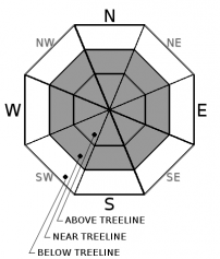
Moderate avalanche danger continues to exist in near and above treeline terrain due to a wind slab avalanche problem.  Low avalanche danger will exist in below treeline terrain.  Human triggered wind slab avalanches remain possible today.

2. Moderate

?

Above Treeline
Heightened avalanche conditions on specific terrain features. Evaluate snow and terrain carefully; identify features of concern.

2. Moderate

?

Near Treeline
Heightened avalanche conditions on specific terrain features. Evaluate snow and terrain carefully; identify features of concern.

1. Low

?

Below Treeline
Generally safe avalanche conditions. Watch for unstable snow on isolated terrain features.
    Heightened avalanche conditions on specific terrain features. Evaluate snow and terrain carefully; identify features of concern.
Avalanche Problem 1: Wind Slab
  • Type ?
  • Aspect/Elevation ?
  • Likelihood ?
    Certain
    Very Likely
    Likely
    Possible
    Unlikely
  • Size ?
    Historic
    Very Large
    Large
    Small

Wind slabs will continue to exist in near and above treeline areas on all aspects.  Winds have been strong in speed from the SW, then shifted to the NE for most of yesterday, and have shifted back to the SW today before our next storm approaches late tonight.  Wind scoured surfaces exist on many aspects alongside existing dense wind slabs.  These existing wind slabs will remain suspect today as they slowly gain strength.  Blowing snow will occur later today as SW winds increase in speed creating new fragile wind slabs.

Look for recent avalanches, shooting cracks, cornices above slopes, blowing snow, or other wind created surface textures to identify where wind slabs may exist.  Avoid steep wind loaded terrain.

recent observations

* A wind slab avalanche was reported from the South Side of Castle Peak (Donner Summit area) on a cross loaded gully feature.  It is unknown if the avalanche was remotely triggered or occurred naturally.  It was on a SW aspect, approximately 100' wide, and 18'' deep.

* Skier triggered shooting cracks in wind loaded terrain were observed on Castle Peak (Donner Summit area) and Grouse Rock (Ward Canyon area).

* Strong NE winds were seen throughout the forecast area in near and above treeline terrain.  Snow transport along with wind effected snow was also experienced in some below treeline terrain.

* Reports of natural wind slab avalanches that occurred during or immediately after the storm on Monday from Elephants Back (Carson Pass area) and Grouse Rock (Ward Canyon area).

Weather and CURRENT CONDITIONS
weather summary

Today will be a mostly quiet day before a strong winter storm approaches our region tonight.  NE winds have shifted to the SW and will begin to increase in speed today and into tonight.  Strong to gale force winds along with heavy snowfall rates will occur from Thursday through Saturday morning.  2 to 5 feet of snow is forecasted for areas above 7000' throughout the forecast area.  The NWS has issued a winter storm warning from 10pm tonight through 10am Saturday morning.   


CONDITIONS ALONG THE SIERRA CREST BETWEEN 8200 FT. AND 9200 FT. IN THE LAST 24 HOURS
6am temperature: 11 to 23 deg. F.
Max. temperature: 28 deg. F.
Average ridgetop wind direction: NE shifting to SW
Average ridgetop wind speed: NE 20 to 50 mph | SW 10 to 20 mph
Maximum ridgetop wind gust: 65 mph
New snowfall: 0 inches
Total snow depth: 39 to 66 inches
Two-Day Mountain Weather Forecast Produced in partnership with the Reno NWS
For 7000 ft. to 8000 ft.
Wednesday Wednesday Night Thursday
Weather: Mostly cloudy. Slight chance of snow showers in the afternoon. Cloudy. Snow showers likely in the evening then snow likely after midnight. Cloudy. Snow.
Temperatures: 30 to 35 deg. F. 21 to 26 deg. F. 30 to 35 deg. F.
Mid Slope Winds: SW SW SW
Wind Speed: Light winds becoming SW 10 to 15mph with gusts to 35mph in the afternoon. 20 to 30mph. Gusts up to 45mph increasing to 65mph after midnight. 20 to 35mph with gusts to 85mph.
Expected snowfall: 0 Likely up to 4 in. | Possible 4 to 5 Likely 7 to 13 in. | Possible 5 to 7
For 8000 ft. to 9000 ft.
Wednesday Wednesday Night Thursday
Weather: Mostly cloudy. Slight chance of snow showers in the afternoon. Cloudy. Snow showers likely in the evening then snow likely after midnight. Cloudy. Snow.
Temperatures: 26 to 32 deg. F. 19 to 24 deg. F. 26 to 31 deg. F.
Ridge Top Winds: SW SW SW
Wind Speed: 15 to 25mph. Gusts to 30mph increasing to 50mph in the afternoon. 20 to 30mph with gusts to 70mph increasing to 30 to 50mph with gusts to 90mph after midnight. 40 to 60mph. Gusts to 105 increasing to 125mph in the afternoon.
Expected snowfall: 0 Likely 1 to 5 in. | Possible 5 to 7 Likely 8 to 14 in. | Possible 5 to 8
Disclaimer

This avalanche advisory is provided through a partnership between the Tahoe National Forest and the Sierra Avalanche Center. This advisory covers the Central Sierra Nevada Mountains between Yuba Pass on the north and Ebbetts Pass on the south. Click here for a map of the forecast area. This advisory applies only to backcountry areas outside established ski area boundaries. This advisory describes general avalanche conditions and local variations always occur. This advisory expires 24 hours after the posted time unless otherwise noted. The information in this advisory is provided by the USDA Forest Service who is solely responsible for its content.

For a recorded version of the Avalanche Advisory call (530) 587-3558 x258