THIS AVALANCHE FORECAST EXPIRED ON February 4, 2018 @ 6:51 am
Avalanche Forecast published on February 3, 2018 @ 6:51 am
Issued by Brandon Schwartz - Tahoe National Forest

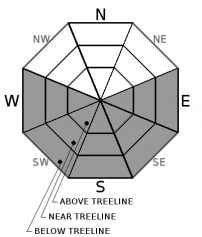
Avalanche danger is LOW for all elevations. Isolated areas of unstable snow will form today. Loose wet is the avalanche problem to look for and avoid. Slab avalanches are very unlikely today on a regional scale.

1. Low

?

Above Treeline
Generally safe avalanche conditions. Watch for unstable snow on isolated terrain features.

1. Low

?

Near Treeline
Generally safe avalanche conditions. Watch for unstable snow on isolated terrain features.

1. Low

?

Below Treeline
Generally safe avalanche conditions. Watch for unstable snow on isolated terrain features.
    Generally safe avalanche conditions. Watch for unstable snow on isolated terrain features.
Avalanche Problem 1: Loose Wet
  • Type ?
  • Aspect/Elevation ?
  • Likelihood ?
    Certain
    Very Likely
    Likely
    Possible
    Unlikely
  • Size ?
    Historic
    Very Large
    Large
    Small

A good snow surface refreeze is expected to have occurred last night due to radiational cooling under clear skies despite above freezing air temperatures overnight at the mid and upper elevations. As daytime warming progresses, most wet snow instability today will present in the form of roller balls and pinwheels. Loose wet avalanches of size D1 (too small to bury a person) could be human triggered in isolated areas of steep terrain. This avalanche problem is most likely on E-SE aspects where a combination of full sun exposure and continuous snow cover exists. This problem is less likely on S-SW-W aspects due to thin patchy snow cover in many areas, but still warrants consideration.

recent observations

* Observations made yesterday in Lincoln Valley (Yuba Pass area) reported surface wet snow at noon limited to only the top 1 to 2 inches of the snowpack on southerly aspects in the 6,900' to 7,500' elevation range. No signs of wet snow instability were observed. Snowpit data collected on a N aspect at 7,650' identified some near crust facets around 2.3 feet deep in the snowpack, but no problematic test results or indications of instability were observed.

* Observations made yesterday on Fireplug (Mount Rose area) found 2 to 4 inches of surface wet snow on SE-S aspects at mid day. Near exposed dirt patches and rocks, the layer of wet snow was deeper at 4 to 6 inches and represented almost all of the snowpack. Ski cuts on a steep SE facing test slope triggered small pinwheels and roller balls. Snowpit data collected from shaded N aspect terrain in this area identified some older layers of faceted snow with no signs of current instability.

* Observations received yesterday from Silver Peak (Pole Creek area) reported supportable crust into the afternoon hours on E aspects at 8,000'. Limited snow cover was reported on all aspects in the Pole Creek drainage below 7,000'. Snowpit data collected near 8,000' on a NNW aspect showed an unlikely to be triggered faceted snow persistent slab structure lingering around 2.7 feet deep in the snowpack.

* A mix of breakable and supportable crusts will have formed in the majority of areas again last night. Only the most heavily shaded upper elevation NW-N-NE aspect terrain will have surface snow that has yet to be affected by melt-freeze.

Weather and CURRENT CONDITIONS
weather summary

High pressure continues to dominate the weather pattern. Sunny skies, clear nights, and maximum daytime air temperatures 15 to 20 degrees above average for this time of year is the ongoing forecast through the weekend. Ridgetop winds out of the NE were moderate in speed for the past 24 hours. Wind speeds are expected to become light today, shifting to light W winds for tomorrow. Air temperature inversion conditions are once again in place this morning with below freezing air temperatures on the mountain valley floors and above freezing air temperatures last night at the mid and upper elevations.

CONDITIONS ALONG THE SIERRA CREST BETWEEN 8200 FT. AND 9200 FT. IN THE LAST 24 HOURS
6am temperature: 38 to 42 deg. F.
Max. temperature: 45 to 53 deg. F.
Average ridgetop wind direction: NE
Average ridgetop wind speed: 30 mph
Maximum ridgetop wind gust: 52 mph
New snowfall: 0 inches
Total snow depth: 28 to 52 inches
Two-Day Mountain Weather Forecast Produced in partnership with the Reno NWS
For 7000 ft. to 8000 ft.
Saturday Saturday Night Sunday
Weather: Sunny skies. Clear skies. Sunny skies.
Temperatures: 52 to 57 deg. F. 30 to 36 deg. F. 51 to 56 deg. F.
Mid Slope Winds: NE NE W
Wind Speed: Light winds Light winds Light winds
Expected snowfall: 0 0 0
For 8000 ft. to 9000 ft.
Saturday Saturday Night Sunday
Weather: Sunny skies. Clear skies. Sunny skies.
Temperatures: 48 to 53 deg. F. 31 to 36 deg. F. 47 to 52 deg. F.
Ridge Top Winds: NE NE W
Wind Speed: 10 to 15 mph Around 10 mph Around 10 mph
Expected snowfall: 0 0 0
Disclaimer

This avalanche advisory is provided through a partnership between the Tahoe National Forest and the Sierra Avalanche Center. This advisory covers the Central Sierra Nevada Mountains between Yuba Pass on the north and Ebbetts Pass on the south. Click here for a map of the forecast area. This advisory applies only to backcountry areas outside established ski area boundaries. This advisory describes general avalanche conditions and local variations always occur. This advisory expires 24 hours after the posted time unless otherwise noted. The information in this advisory is provided by the USDA Forest Service who is solely responsible for its content.

For a recorded version of the Avalanche Advisory call (530) 587-3558 x258